9,576
Views
47
CrossRef citations to date
0
Altmetric
Articles

A comprehensive approach and methods for glacial lake outburst flood risk assessment, with examples from Nepal and the transboundary area

, , , , , & show all
Pages 219-237 | Received 10 Sep 2014, Accepted 29 Nov 2014, Published online: 29 Jan 2015

Figures & data

Figure 1 Step-by-step approach for glacial lake outburst flood risk assessment and management.

Table 1 Potentially dangerous lakes in Nepal, by priority.

Figure 2 Locations of study area and lakes selected for detailed investigation.
Figure 3 Schematic diagram of the steps used in GLOF modelling and inundation mapping. Note: HEC-GeoHMS =  Hydrologic Engineering Center Geospatial Hydrologic Modeling System Extension; HEC-GeoRAS =  Hydrologic Engineering Center Geospatial River Analysis System; HEC-RAS =  Hydrologic Engineering Center River Analysis System; BOSS DAMBRK =  Boss International dam-break flow simulation model; NWS BREACH =  National Weather Service dam-breach flood forecasting model.
Figure 4 Maximum discharge and time for flood to reach selected downstream locations.
Figure 5 Maximum discharge and flood depth at selected downstream locations.

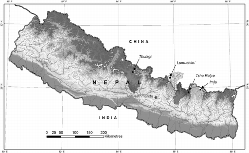
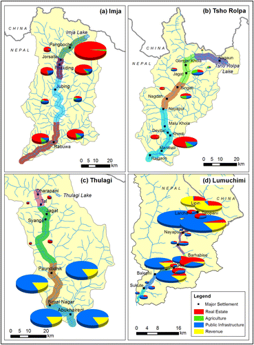
Table 2 Land, people, and houses potentially affected by glacial lake outburst floods.

Table 3 Crops potentially exposed to glacial lake outburst floods (in tonnes).

Table 4 Infrastructure potentially exposed to glacial lake outburst floods.

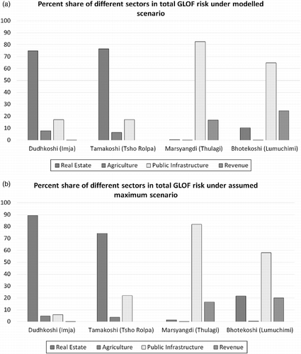
Table 5 Monetary value of elements potentially exposed to glacial lake outburst flood risk (USD thousands).

Figure 6 Share of different sectors in total value exposed to glacial lake outburst flood risk (a) under the modelled flood scenario and (b) under the maximum affected level.
Figure 7 Monetary value of property exposed to glacial lake outburst flood risk under the modelled flood scenario (left-side charts in each figure) and the maximum affected level (right-side charts).

Table 6 Percentage of households with different indicators of vulnerability in total households within areas susceptible to glacial lake outburst floods.