Figures & data
Figure 1 Gippsland Basin locality and major geostrophic currents effecting the southern Australian margin (modified from Smith and Gallagher Citation2003, who adapted Martinez Citation1994 and James et al. Citation1999).
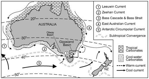
Figure 2 High-resolution swath-mapped seafloor bathymetry image of the offshore Gippsland Basin and Bass Canyon. Locality of R/V Franklin cruise FR11/98 shallow (sparker) seismic survey, piston-core sites, and major Esso/BHP oil and gas production platforms. Bathymetry data provided by Geoscience Australia (Exon et al. Citation1999; Harris et al. Citation2000). The study area extends southeast from Ninety Mile Beach to Bass Canyon. Most good-quality shallow seismic lines are figured.
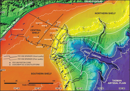
Figure 3 (a) Airborne magnetic imagery of the Gippsland Basin showing buried magnetic fluvial channels and magnetic barrier features identified by Holdgate et al. (Citation2003). Image processed by the Geological Society of Victoria. Light pixels equate to high magnetic regions. (b) Simplified interpretation of airborne magnetic image, location of buried Plio-Pleistocene canyon heads, present-day canyon features and isobaths, and major petroleum platforms and pipelines. Numbers correspond with ‘seismic smudges’ identified on FR11/98 shallow seismic survey and match those labelled in and .
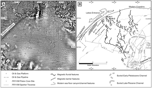
Figure 4 Correlation of Esso/BHP foundation bore logs from the main offshore Gippsland Basin oil and gas fields amended from Holdgate et al. (Citation2003). Strata are tied to the FR11/98 shallow seismic survey ( ) and have been divided into six units of approximately equal seismic thickness (time), defined by seismic facies and significant surfaces. Units are biostratigraphically age-constrained (McMinn Citation1992; Shafik Citation2000; Mays Citation2001; Holdgate et al. Citation2003).
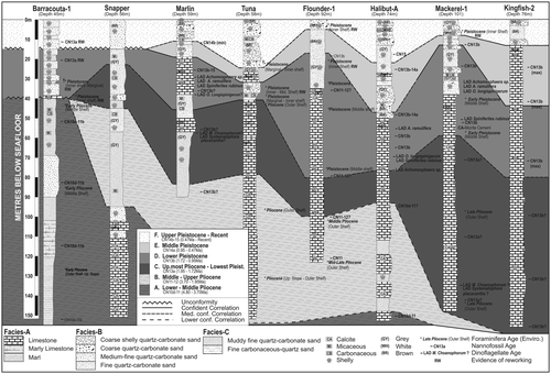
Figure 5 Interpreted and uninterpreted FR11/98 sparker line L22, which runs roughly along-strike (shore-parallel) across the inner and middle shelves. Nearby Esso/BHP foundation bores are structurally projected onto line, and Pleistocene magnetic fluvial channels located. See for traverse location.
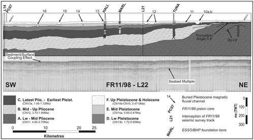
Figure 6 Interpreted and uninterpreted FR11/98 sparker lines (a) L21 and (b) L14, which run downdip from shoreface to upper slope. Nearby Esso/BHP foundation bores are structurally projected onto lines, and Pleistocene magnetic fluvial channels located. See for traverse location.
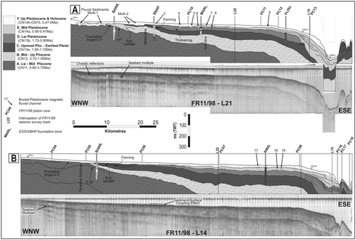
Figure 7 Interpreted and uninterpreted FR11/98 sparker lines (a) L15, middle shelf along-strike transect and (b) L13, L2 and L20, shelf-break and canyon-heads transect. Nearby Esso/BHP foundation bores are structurally projected on to line L15. See for traverse location.
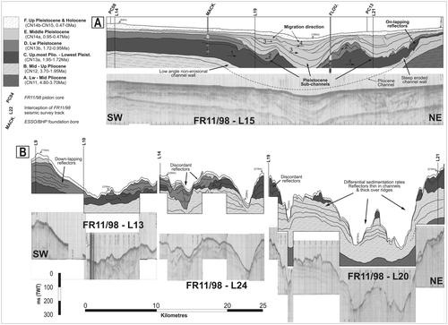
Figure 8 Interpreted and uninterpreted FR11/98 sparker lines (a) L19 and (b) the northern portion of L07, both downdip projections that profile the shelf-break. See for traverse location.
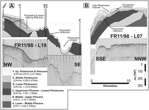
Figure 9 Example of a ‘seismic smudge’ as identified by Holdgate et al. (Citation2003). This particular seismic smudge correlates with magnetic fluvial channel 9 ( ) on FR11/98 line L21 and is Late Pleistocene in age.
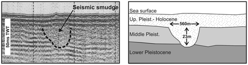
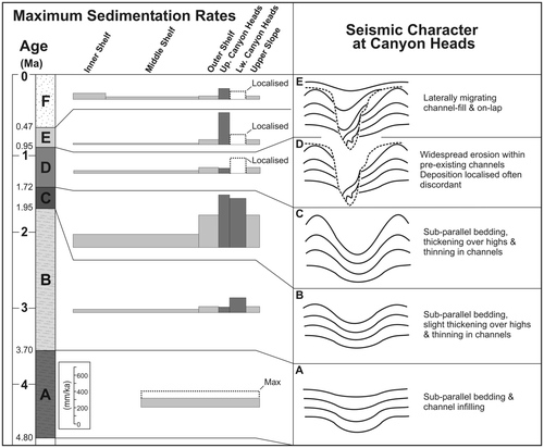
Figure 10 Maximum (compacted) sedimentation rates and seismic characteristics for the inner shelf to upper slope and canyon-heads regions of the Gippsland Basin, Pliocene to Holocene geology, as expressed in the FR11/98 seismic survey. A – F refer to stratigraphy in – .