Figures & data
Figure 1. Location of the Ooloo Hill Formation with respect to the Tasman Orogen, Thomson Orogen and other orogenic and cratonic regions of southeast Australia. Also shown are outlines of the extent of the Warbuton Basin and Eromanga Basin, outlined so as to not obscure the underlying Proterozoic–Paleozoic regions. Note that the change in colour of Delamerian and Thomson orogens at their western margin shows regions of overlap with underlying Archean–Proterozoic basement. Insert shows location with respect to Australia. All province regions are from Geoscience Australia Australian Geological Provinces 2018.01 edition (Raymond, Citation2018). Base layer is Australian Total Magnetic Intensity grid from Geoscience Australia in black–white stretch (Minty & Poudjom Djomani, Citation2019).
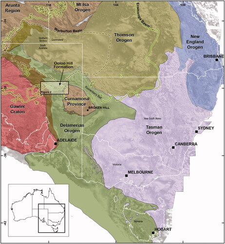
Figure 2. Surface geology and total magnetic intensity (TMI) maps of the northern Flinders area, showing the location of drillholes that intersect the Ooloo Hill Formation. (a) Simplified surface geology of the northern Flinders area. (b) Aeromagnetic TMI imagery showing the location of the magnetic anomaly that forms the Ooloo Hill Formation. (c) Location of the drillholes that intersect the Ooloo Hill Formation. Drillhole RD/DD94WB2 penetrates basalt lavas below ∼280 m Mesozoic to Cenozoic cover. Drillholes RD/DD94WB3 and RD/DD94WB4 penetrate siltstones, shales and minor sandstones, below ∼300 m Mesozoic to Cenozoic cover.
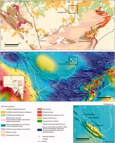
Figure 3. Graphic log and depositional regime to cored drillhole RD/DD94WB2 showing sample depths and analysis type for each sample collected. The basalt lavas and sedimentary succession occur below 279.5 m of Cretaceous to Cenozoic cover.
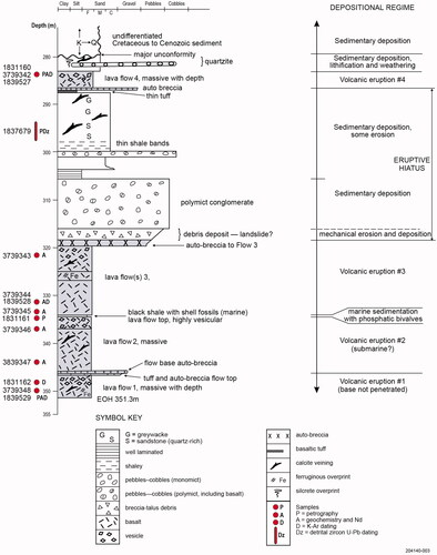
Table 1. Summary of samples, depths and analysis types from drillhole RD/DD94WB2 (GDA2020, 307424 mE, 6701243 mN, Zone 54).
Figure 4. Rock types of the Ooloo Hill Formation. (a) Laminated marine shale and siltstone with soft sediment slumping in drillhole RD/DD94WB3, 352–355 m. (b) Sandstone, drillhole RD/DD94WB2, ∼296 m. (c) Inter-volcanic–sedimentary rock. The conglomerate consists of rounded to subangular dark grey basalt clasts with an interstitial matrix of lithic-rich sand and silt in drillhole RD/DD94WB2, 297.5–302 m. (d) Bedded sedimentary rock with intercalated sandy and silty shale layers, including calcareous and phosphatic shell fragments from RD/DD94WB2, ∼335 m. (e) Autobreccia flow top or bottom RD/DD94WB2, ∼285 m. (f) Fine-grained basalt from drillhole RD/DD94WB2, ∼348 m (flow #2). (g) Fine-grained basalt from drillhole RD/DD94WB2, ∼331–332 m (flow #3). (h) Vesicular basalt, fine-grained basalt with amygdaloidal flow top in drillhole RD/DD94WB2, ∼336 m (flow #4).
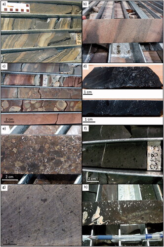
Figure 5. Photomicrographs of some Ooloo Hill Formation components. (a) Inter-lava flow. Bedded shale with intercalated fine-grained sand, silt, and mud layers, including accumulation of calcareous and phosphatic shell fragments. In the middle left of field are mid-sized fragments of an impunctate calcareous brachiopod shell displaying primary and secondary layers. The brownish (presumably phosphatic) shell fragment next to the brachiopod fragment could be an external plate of an armoured fish (G. Brock pers. comm., 2021), sample 1831161, ∼335 m RD/DD94WB2. (b) Inter-lava flow. Isolated phosphatic or calcareous bivalve shells (2–3 mm long, lower left corner). Thin shelled, low convexity shell fragments of indeterminate brachiopods (possibly strophomenids (G. Brock pers. comm., 2021)); sample 1831161, ∼335 m RD/DD94WB2. (c) Quartz-rich, fine-grained sandstone with extensive interstitial carbonate, minor feldspars, muscovite, tourmaline, leucoxene and opaque oxides, sample 1837680, ∼358 m RD/DD94WB3. (d) Inter-lava flow sedimentary rock. Porous quartz-rich fine- to medium-grained sandstone with minor interstitial chlorite, carbonate, and clay. Sample 1837679, ∼295 m RD/DD94WB3. (e) Lowest flow basalt composed of albite–chlorite–carbonate-altered olivine basalt with clinopyroxene in a fine-grained groundmass of flow-orientated plagioclase laths. Former olivine phenocrysts up to 2.5 mm have been altered to chlorite ± carbonate, sample 1722520, 349.14 m, RD/DD94WB2 (flow #1). (f) Flow-orientated plagioclase laths in lower flow basalt, sample 1722518, 337.67 m, RD/DD94WB2 (flow #2). (g) Middle lower lava flow basalt composed of altered olivine basalt with clinopyroxene (possibly titanaugite) in a fine-grained groundmass. Large (up to 1 mm) and flow-oriented plagioclase laths are present, sample 1722516, 331.7 m RD/DD94WB2 (flow #3). (h) Top lava flow composed of weakly plagioclase porphyritic amygdaloidal basalt with quartz–biotite–hematite–chlorite alteration. Amygdales are filled with carbonate ± epidote ± chlorite. No visible olivine phenocrysts were observed in this sample. Sample 1722514, 283.25 m, RD/DD94WB2 (flow #4).
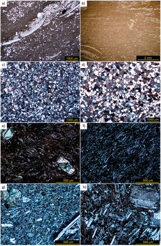
Table 2. K–Ar geochronology results for basalts from the Ooloo Hill Formation.
Figure 6. Representative zircon from Ooloo Hill Formation sedimentary rocks representing (a) 1837679; and (b) 1837680 in transmitted light (left) and CL (right). The grains are rounded with pitted surfaces from sedimentary abrasion. White scale bars represent 100 mm.
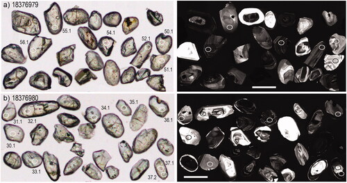
Figure 7. Probability density distributions (PDDs) of zircon ages for the Ooloo Hill Formation sedimentary rocks: (a) 1837679 from drillhole RD/DD94WB2, and (b) 1837680 from drillhole RD/DD94WB3. Peak ages listed on the graphs are calculated using AgeDisplay (Sircombe, Citation2004). The grey-shaded areas represent rejected analyses (see Supplemental data, Appendix 3), which are not included in the peak age calculations.
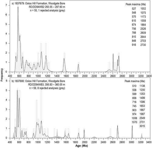
Figure 8. Classification diagrams for the Ooloo Hill Formation basalts. (a) Total alkali silica (TAS) diagram after Middlemost (Citation1994) showing the compositional range from basalt to trachy-andesite between eruptive sequences in the Ooloo Hill Formation. (b) Alkali (Na2O + K2O)–FeO(tot)–MgO (AFM) diagram after (Irvine & Baragar, Citation1971) showing the calc-alkaline affinity of the lower eruptive sequences (#1–3) compared with the tholeiitic composition of eruptive sequence #4.
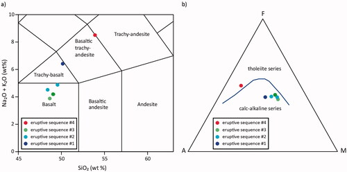
Figure 9. Selected major and trace elements against MgO for Ooloo Hill Formation basalts.
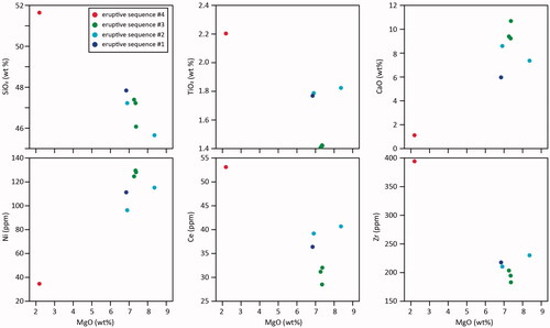
Table 3. Whole-rock geochemical data for mafic volcanic rocks from the Ooloo Hill Formation from drill hole RD/DD94WB 2 (GDA2020, 307424 mE, 6701243 mN, Zone 54).
Figure 10. Primitive mantle-normalised trace-element and chondrite-normalised rare earth element plots for the Ooloo Hill Formation basalts. Primitive mantle and chondrite normalising values from (Sun & McDonough, Citation1989). OIB, Ocean Island Basalt (Sun & McDonough, Citation1989); CIB, Continental Intraplate Basalt, Ethiopian Rift (GEOROC database); EMORB, enriched mid-ocean ridge basalt (Klein, Citation2004); NMORB, normal mid-ocean ridge basalt (Hart et al., Citation1999).
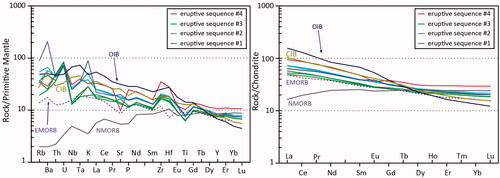
Table 4. Sm–Nd data for basalts and andesite from Ooloo Hill Formation.
Figure 11. εNd(i) plots for Ooloo Hill Formation basalts compared with Neoproterozoic and Cambrian basaltic and sedimentary rocks: (a) εNd(i) vs age evolution diagram for Ooloo Hill Formation basalts, (b) εNd(i) vs SiO2, (c) εNd(i) vs MgO, (d) εNd(i) vs La/Sm and (e) εNd(i) vs Zr. Horizontal trends εNd(i) in (b–e) are consistent with fractional crystallisation (F; horizontal arrow) rather than crustal contamination (C; oblique arrow) of Neoproterozoic or Cambrian aged sedimentary basement rocks. Data sources: Adelaide Fold Belt and Cambrian basalts from Foden et al. (Citation2002); Neoproterozoic and Cambrian sedimentary rocks from Turner et al. (Citation1993); and N-MORB and OIB from Sun and McDonough (Citation1989). εNd(i) values calculated at 390 Ma.
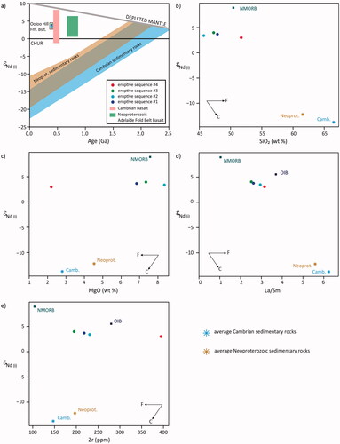
Figure 12. Source discrimination diagrams for Ooloo Hill Formation basalts. (a) Th/Yb–Nb/Yb diagram after Pearce (Citation2008). Note the overlap between eruptive sequences #1 and #2 (see inset). (b) Nb/La–La/Yb diagram after Abdel-Rahman (Citation2002). (c) Zr/Y–Zr diagram after Pearce and Norry (Citation1979) showing the within-plate basalt classification for the Ooloo Hill Formation basalts. The trend formed in eruptive sequences #1, #2 and #4 on (a) and (b) raises the possibility that these basalts share a common mantle source, while eruptive sequence #3 sits on a different trend, suggesting a separate mantle source.
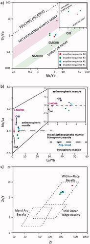
Figure 13. Conceptual diagram of tectonic setting for the Ooloo Hill Formation. (a) Lithospheric scale conceptual diagram showing upwelling of asthenospheric mantle related to pre-existing topography on the lithosphere–asthenosphere boundary, or lithosphere flexure related to far-field stresses, either of which led to localised partial melting. The presence of translithospheric magma ascent pathways may be related to pre-existing weaknesses in the region, with magma being focused towards the mid- to lower-crust before erupting into a fault-bound basin. Diagram not to scale. (b) Detail of eruptive sequences for the Ooloo Hill Formation, emphasising the different magma sources between flows, which have distinct geochemical signatures. Note sedimentation was most widespread between flows #3 and #4, during which time some degree of fractional crystallisation occurred, presumably in a magma chamber setting that influenced the modest enrichment observed in flow #4.
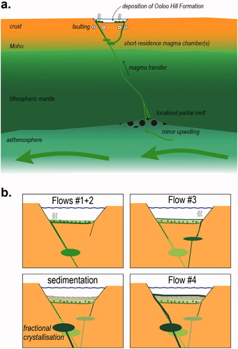
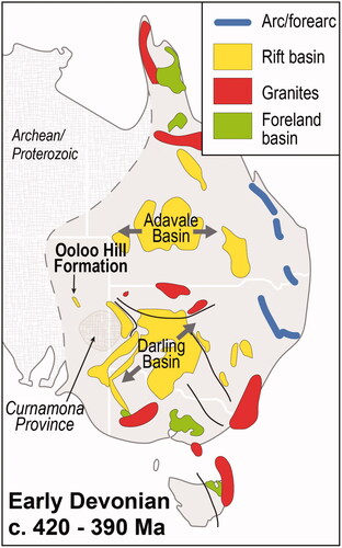
Figure 14. Sketch map showing major sedimentary and igneous regions of eastern Australia formed during the Early Devonian, modified from Rosenbaum (Citation2018). The Ooloo Hill Formation is shown as an example of a small rift basin developed above pre-existing crust to the northwest of the Coompana Province. The Adavale and Darling basins are indicated, with approximate axis of extension that formed the basin after Rosenbaum (Citation2018). Archean/Proterozoic terranes are undifferentiated.