Publication Cover
Historical Biology
An International Journal of Paleobiology
Volume 27, 2015 - Issue 6: RIO PTEROSAUR
3,790
Views
28
CrossRef citations to date
0
Altmetric
Articles

An analysis of pterosaurian biogeography: implications for the evolutionary history and fossil record quality of the first flying vertebrates

, , &
Pages 697-717 | Received 24 Apr 2014, Accepted 24 Jun 2014, Published online: 28 Jul 2014

Figures & data

Figure 1 The pterosaur relationships and stratigraphical/geographical ranges used in the ‘all taxa’ Treefitter data-set. This tree is based on the cladogram presented by Andres et al. (Citation2014) and shows the more basal portion in detail (Eupterodactyloidea has been condensed to a single branch – see Figure 2). The thick branches represent known stratigraphical ranges (based on data in The Paleobiology Database); thin branches represent estimated ghost ranges and connectors used to demarcate phylogenetic relationships. Time-sliced data-sets were derived from this tree by appropriate inclusion/exclusion of taxa. Most stratigraphical stage and taxon abbreviations are listed in the legend of Table . Additional abbreviations: CA, Central Asia; CO, Coniacian; EA, East Asia; Eop, Eopterosauria; EU, Europe; Euc, Euctenochasmatia; KI, Kimmeridgian; NA, North America; OX, Oxfordian; RH, Rhaetian; SA (after taxon name), South America; SA (time scale), Santonian; TU, Turonian.
Figure 1 The pterosaur relationships and stratigraphical/geographical ranges used in the ‘all taxa’ Treefitter data-set. This tree is based on the cladogram presented by Andres et al. (Citation2014) and shows the more basal portion in detail (Eupterodactyloidea has been condensed to a single branch – see Figure 2). The thick branches represent known stratigraphical ranges (based on data in The Paleobiology Database); thin branches represent estimated ghost ranges and connectors used to demarcate phylogenetic relationships. Time-sliced data-sets were derived from this tree by appropriate inclusion/exclusion of taxa. Most stratigraphical stage and taxon abbreviations are listed in the legend of Table 1. Additional abbreviations: CA, Central Asia; CO, Coniacian; EA, East Asia; Eop, Eopterosauria; EU, Europe; Euc, Euctenochasmatia; KI, Kimmeridgian; NA, North America; OX, Oxfordian; RH, Rhaetian; SA (after taxon name), South America; SA (time scale), Santonian; TU, Turonian.
Figure 2 The pterosaurian relationships and stratigraphical/geographical ranges used in the ‘all taxa’ Treefitter data-set. This tree is based on the cladogram presented by Andres et al. (Citation2014) and shows the relationships among Eupterodactyloidea (see Figure 1 for the more basal part of the cladogram). The thick branches represent known stratigraphical ranges (based on data in The Paleobiology Database); thin branches represent estimated ghost ranges and connectors used to demarcate phylogenetic relationships. Time-sliced data-sets were derived from this tree by appropriate inclusion/exclusion of taxa. All abbreviations are listed in the legend of Table and/or Figure 1.
Figure 2 The pterosaurian relationships and stratigraphical/geographical ranges used in the ‘all taxa’ Treefitter data-set. This tree is based on the cladogram presented by Andres et al. (Citation2014) and shows the relationships among Eupterodactyloidea (see Figure 1 for the more basal part of the cladogram). The thick branches represent known stratigraphical ranges (based on data in The Paleobiology Database); thin branches represent estimated ghost ranges and connectors used to demarcate phylogenetic relationships. Time-sliced data-sets were derived from this tree by appropriate inclusion/exclusion of taxa. All abbreviations are listed in the legend of Table 1 and/or Figure 1.
Figure 3 Palaeogeographical map for the Late Triassic (210 Ma) showing the locations of 29 collections of pterosaurian specimens. The map was generated using software available at Fossilworks (Alroy Citation2013), with collections data downloaded from The Paleobiology Database.
Figure 4 Palaeogeographical map for the Early and Middle Jurassic (170 Ma) showing the locations of 88 collections of pterosaurian specimens. The map was generated using software available at Fossilworks (Alroy Citation2013), with collections data downloaded from The Paleobiology Database.
Figure 5 Palaeogeographical map for the Late Jurassic (150 Ma) showing the locations of 77 collections of pterosaurian specimens. The map was generated using software available at Fossilworks (Alroy Citation2013), with collections data downloaded from The Paleobiology Database.
Figure 6 Palaeogeographical map for the Early Cretaceous (130 Ma) showing the locations of 176 collections of pterosaurian specimens. The map was generated using software available at Fossilworks (Alroy Citation2013), with collections data downloaded from The Paleobiology Database.
Figure 7 Palaeogeographical map for the Late Cretaceous (80 Ma) showing the locations of 182 collections of pterosaurian specimens. The map was generated using software available at Fossilworks (Alroy Citation2013), with collections data downloaded from The Paleobiology Database.

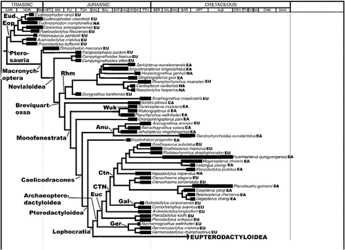
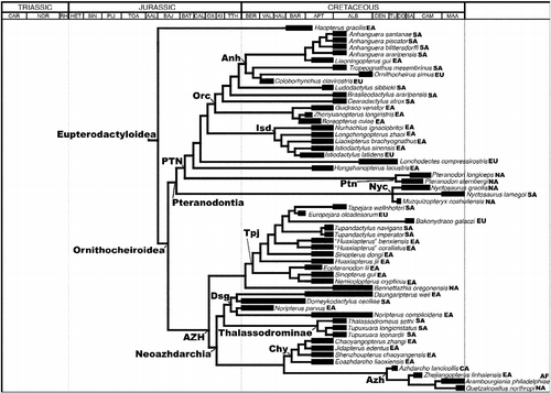
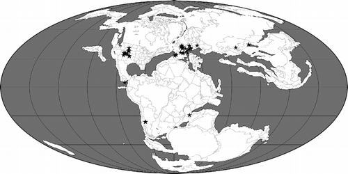
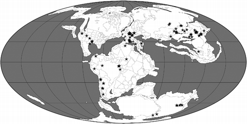
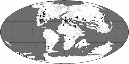
Table 1 A summary of the geographical and stratigraphic distributions of pterosaur families and other major clades (based on Barrett et al. Citation2008 modified by Andres, personal data).

Table 2 Summary of results of Treefitter analyses based on SC and MC costs.

Table 3 Biogeographical event frequencies.

Supplemental material