
Figures & data
Table 1. LIS priority habitats included in this assessment.
Figure 1. LIS basins used for habitat status analysis.
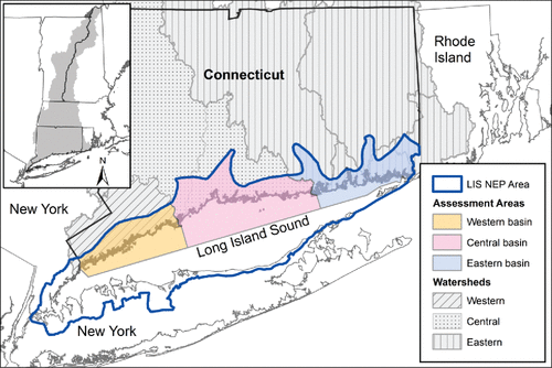
Table 2. Eelgrass habitat assessment metrics. Density and Bed Size Metric corresponds to eelgrass surveys in LIS as: VERY LOW = low; LOW = lower half of medium, MEDIUM = upper half of medium, HIGH = high (MacLachlan Citation2014; Tiner, McGuckin, and MacLachlan Citation2013).
Table 3. Embayment habitat assessment metrics. All data came from a rapid assessment of embayments conducted in late summer, 2011-2013; and are thus directly comparable among all sites (Vaudrey Citation2015; Vaudrey et al. Citation2013b).
Table 4. Tidal wetland habitat assessment metrics.
Table 5. Riverine migratory corridor (RMC) assessment metrics.
Table 6. Coastal forest habitat assessment metrics. All metrics used 2010 UConn CLEAR land cover data, 30 m resolution (CLEAR Citation2012). Fragmentation was determined using the UConn CLEAR Landscape Fragmentation Tool (CLEAR Citation2007). Only forests within the defined coastal boundary were assessed.
Figure 2. LIS priority habitat health. Habitat scores are out of 100. Colors denote indicator score using evaluation criteria in –. Red is poor, yellow is fair, light green is good, and dark green is very good. Pie chart areas represent weighting applied to indicators when calculating the basin scores.
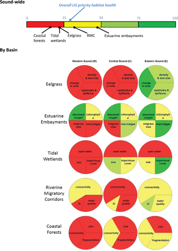
Figure 3. Comparison of habitat quality with economic valuation. Total value of habitats for the low and high per acre estimate () illustrate the relative estimated value of habitats in LIS. Area of each type is presented for comparison. Red indicates poor habitat quality and yellow indicates fair habitat quality as presented in .
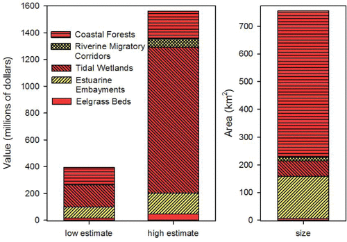
Table 7. Landscape-level assessments in select coastal programs. white = no habitat extent data found, grey = existing or restored habitat extent tracked; M = multiple indicators tracked; H = multi indicator assessment synthesized into a habitat health rank; N/A = not applicable (ecologically relevant) based LIS habitat definitions.
Table 8. Services, resilience, and value of LIS habitats. Column A includes major contributors to habitat resilience (bold = factors that contribute to habitat resilience in the face of climate change). Column C provides the health status, economic value, current extent, and estimated value to LIS.