Figures & data
Figure 1. Outline tectonic map of the circum-Black Sea region of NE Turkey. This paper focuses on the eastward extension of the İzmir–Ankara–Erzincan suture zone through the Eastern Pontides, and comparisons especially with the Central Pontides and the Lesser Caucasus. Modified from Ustaömer and Robertson (Citation2010). PCF, Peceneaga Camena Fault; CTF, Caucasian Thrust Front; S, Svenata uplift; RD, Rioni Depression; DZ, Dzirula salient; KH, Khrami salient; LS, Lochi salient; CUZ, Chorchana–Utslevi Zone.
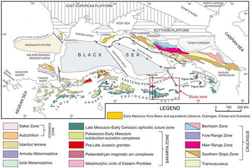
Figure 2. Simplified N–S cross-sections of the İzmir–Ankara–Erzincan suture zone in the Eastern Pontides. (a) West of the area; (b) East of the area (see Figure ). Based on the 1:500,000 Geological Map of Turkey (MTA, Citation2002), with modifications resulting from this work. NAF North Anatolian Transform Fault.
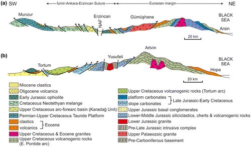
Figure 3. Outline tectonic map of the İzmir–Ankara–Erzincan suture zone and its eastward extension (Erzurum–Kars suture zone), cover units, together with the Eurasian continental margin and the Tauride continental margin to the south. Areas studied here are shown by the boxes and lines of section. Simplified from the 1:500,000 Geological Map of Turkey (MTA, Citation2002).
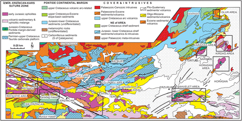
Figure 4. Summary tectono-stratigraphy based on this work. A Cretaceous subduction-accretion complex is overthrust by Lower Jurassic ophiolites. These are intercalated with Jurassic–Cretaceous sedimentary rocks derived from the Eurasian continental margin. The ophiolite is overthrust by contrasting sedimentary and volcanogenic successions in the east vs. the west of the region. Several units of metamorphic rocks (locally dated as Jurassic) are excluded because they occur in different structural positions in different areas.
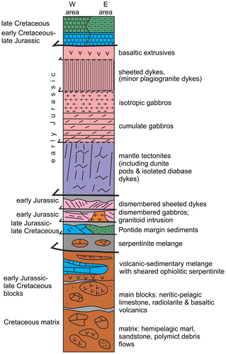
Figure 5. Outline tectonic map of the Şahvelet area, Erzurum Region. An upper, folded thrust sheet of ophiolitic rocks, mostly serpentinised peridotite, is structurally underlain by the volcanic-sedimentary and ophiolitic melange. In different areas, the melange and/or the ophiolite are overthrust by Upper Cretaceous deep-water pelagic and volcaniclastic sediments derived from the Eurasian continental margin (see Figure for location; compiled from Parlak, Çolakoğlu, et al., Citation2013; Tarhan, Citationl988; Yılmaz, Terlemez, & Uysal, Citation1986, Citation1988a, Citation1988c, Citationl989; Yilmaz et al., Citation1988b; Yilmaz & Uysal, Citation1988 and this study).
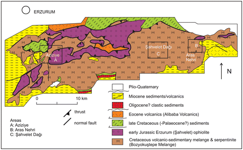
Figure 6. Outline tectonic map of the area north of Horasan, Kars Region. Two contrasting types of melange are exposed. First, volcanic-sedimentary melange, with exotic blocks (e.g. limestone; volcanics), set in a sedimentary matrix and, secondly, ophiolitic melange made up of dismembered ophiolitic rocks. There are also dismembered sequences of Upper Cretaceous mixed carbonate-volcaniclastic sediments that are interpreted as part of the emplaced Eurasian continental margin (see Figure for location; compiled from Konak and Sümengen (Citation2009) and this study).
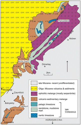
Figure 7. Outline tectonic map of the Erzincan area (Erzincan and Gümüşhane regions). An ophiolite, complete other than for extrusive rocks, is thrust over volcanic-sedimentary and ophiolitic melange. Both units are unconformably covered by Eocene sediments and, in some areas, by Miocene and Plio–Quaternary sediments. Outcrops of greenschist facies metamelange occur in the south and northeast. The southern part of the area is cut by the North Anatolian Transform Fault, which is this area is associated with formation of the neotectonic Erzincan pull-apart basin (see Figure for location; compiled from Aktimur et al., Citation1995; Parlak, Çolakoğlu, et al., Citation2013; Tarhan, Citationl988, Citation2007a, Citation2007b and this study).
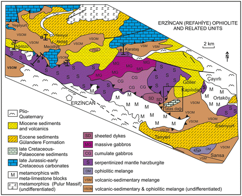
Figure 8. Cross-sections and measured logs of local sequences within blocks and dismembered thrust sheets that form part of the volcanic-sedimentary and ophiolitic melange, (a) volcanogenic lithologies, depositionally overlain by radiolarian sediments, passing upwards into volcanogenic shale; (b) volcanogenic lithologies depositionally overlain by redeposited limestones and then by radiolarian and hydrothermal sediments, passing upwards into shale; (a–b) East side of Aras Nehri (river) near road bridge; Şahvelet area; (c) volcanogenic lithologies depositionally overlain by chert, passing upwards into limestone; NE of Aziziye, Şahvelet area, Erzurum Region). Samples that were dated using radiolarians (numbers with arrows) are also shown in Figure (a) and (b), together with data from other areas. See text for discussion.
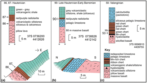
Figure 9. Occurrences of dated radiolarites associated with blocks and dismembered thrust sheets within the volcanic-sedimentary and ophiolitic melange. (a) Upper Tithonian radiolarites spatially associated with basaltic pillow lava (although separated by a thin thrust sheet of sheared serpentinite), E of Erzincan; (b) Pliensbachian radiolarites stratigraphically interbedded with pillow lavas, E of Erzincan; (c) Lower Turonian radiolarites overlying pillow basalt, near Otlukbeli, SW of Bayburt; (d) Valanginian? radiolarites overlying pillow basalt, near Aziziye, Erzurum Region; (e) Late Hauterivian–Early Barremian radiolarites overlying pelagic limestones that, in turn, cover massive basalt, Şahvelet area; (f) Pliensbachian radiolarites stratigraphically interbedded with massive basalt; Şahvelet area. Bedding is recorded as angles of dip and strike. See text for explanation.
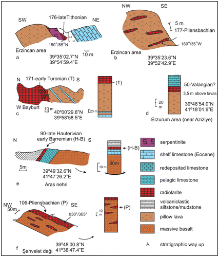
Figure 10(A). SEM images of age-diagnostic Radiolarian from blocks associated with basaltic rocks in the volcanic-sedimentary and ophiolitic melange. Sample E2-11-50 (near Azize; Şahvelet area). 1 – Acanthocircus sp. ×100; 2 – Dicerosaturnalis amissus (Squinabol), 3 – Acaeniotyle cf. diaphorogona Foreman, 4 – Acaeniotyle cf. diaphorogona Foreman, ×100; 5 – Angulobracchia cf. biordinalis Ozvoldova, ×150; 6 – Angulobracchia cf. portmanni Baumgartner, ×75; 7 Aurisaturnalis variabilis (Squinabol), 250; 8 – Praeconosphaera sphaeroconus (Rüst), ×150; 9, 10 – Archaeodictyomitra cf. praegutta Dumitrica, ×100; 11 – Pseudodictyomitra cf. carpatica (Lozyniak), ×150; 12 – Sethocapsa? sp., ×200; 13 – Spongacapsula obesa Jud, ×200; 14 – Thanarla pulchra (Squinabol), ×200; 15 – Archaeodictyomitra sp., ×125; 16 – Nassellaria gen. et sp. indet., ×125. Sample E2-11-86 (Aras Nehri gorge; Şahvelet area) 17 – Alievium regulare (Wu & Li), ×125; 18 – Sethocapsa trachyostraca Foreman, ×125; 19 Sethocapsa uterculus Parona, ×250; 20 – Syringocapsa limatum Foreman, ×100; 21 – Svinitzium pseudopuga Dumitrica, ×150; 22 – Suna echiodes (Foreman), ×150; 23 – Pseudoxitus laguncula Dumitrica, ×150; 24 – Pseudodictyomitra nodocostata Dumitrica, ×150; 25 – Pseudoaulophacus (?) florealis Jud, ×125; 26 – Syringocapsa spinosa (Squinabol), ×150; 27 – Parvicingula usotanensis Tumanda, ×150; 28 – Tethysetta boessi gr. (Parona), ×125; 29 – Pantanellium sp., ×100; 30 – Mirifusus dianae (Karrer), ×85; 31 – Mictyoditra curvata Dumitrica, ×150; 32 – Holocryptocapsa hindei (Tan), ×130; 33 – Hemicryptocapsa capita Tan, ×150; 34 – Dicerosaturnalis trizonalis (Rüst), ×100; 35 – Crucella bossoensis Jud, ×125; 36 – Cecrops septemporatus (Parona), ×150; 37 – Pseudoeucyrtis sp., ×150.
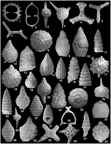
Figure 10(B). SEM images of age-diagnostic Radiolarian from blocks associated with basaltic rocks in the volcanic-sedimentary and ophiolitic melange. Sample E2-11-87 (Aras Nehri gorge; Şahvelet area): 1 – Archaeodictyomitra apiarium (Rüst), ×150; Pantanellium squinaboli (Tan), ×200; 3 – Pantanellium sp., ×200; 4 – Sethocapsa trachyostraca Foreman, ×100; 5 – Svinitzium pseudopuga Dumitrica, ×125; 6 – Xitus sp., ×125. Sample E2-11-90 (Aras Nehri gorge; Şahvelet area): 7 – Alievium regulare (Wu & Li), ×125; 8 – Archaeotritrabs gracilis Steiger, ×100; 9 – Becus helenae (Schaaf), ×125; 10 – Napora sp., ×200; 11 – Orbiculiforma satoi Tumanda, ×100; 12–14 – Pantanellium masirahense gr. Dumitrica, ×125; 15 – Tethysetta usotanensis (Tumanda), ×150; 16 – Phaseliforma cf. micropora (Tan), ×100; 17 – Praexitus alievi (Foreman), ×100; 18 – Tetracapsa sp., ×200; 19 – Thanarla conica (Aliev), ×200; 20 – Veghicyclia ? sp.; 21 – Xitus robustus Wu, ×150. Sample E2-11-94 (Aras Nehri gorge; Şahvelet area): 22 – Thanarla cf. gutta Jud, ×100; 23 – Archaeodictyomitra sp., ×125; Sample E2-11-106 (Şahvelet Dağ) (24 – Gigi fustis De Wever, ×150; 25–26 – Lantus intermedius gr. Carter, ×150. Sample E2-11-177: 27 – Canoptum cf. anulatum Pessagno & Poison, ×125; 28 – Canoptum cf. artus Yeh, ×100; 29 – Droltus sp., ×200. Sample E2-11-176 (E of Erzincan): 30 – Pantanellium aff. riedeli Pessagno, ×125; 31 – Saitoum cf. labeosum Dumitrica & Zügel, ×150; 32 – Bernoullius cf. delnortensis Pessagno, Blome & Hull, ×150; 33 – Pseudodictyomitra primitiva Matsuoka & Yao, ×150; 34 – Perispyridium ordinarium (Pessagno), ×150; 35 – Protunuma costata (Heitzer), ×150; 36 – Spongocapsula sp., ×100; 37 – Emiluvia chica Foreman, ×150; 38 – Napora deweveri Baumgartner, ×150. Sample E2-11-171 (Otlukbeli area): 39 – Pseudodictyomitra pseudomacrocephala (Squinabol), ×100; 40 – Crucella cachensis Pessagno, ×125; 41 – Hemicryptocapsa praepolyhedra Dumitrica, ×150; 42 – Archaeodictyomitra sp.1, ×125; 43 – Alievium superbum (Squinabol), ×150; 44 – Archaeodictyomitra sp.2, ×175; 45 – Patellula ecliptica O’Dogherty, ×125.
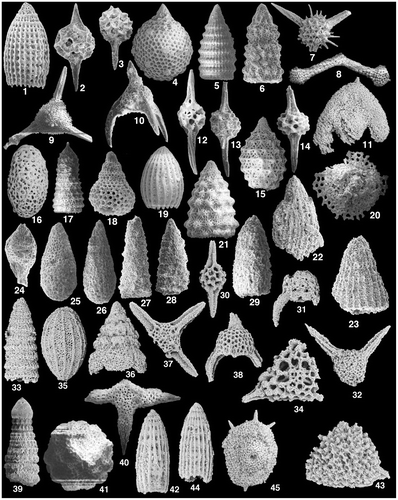
Figure 11. Field photographs. (a) Volcanic-sedimentary melange showing blocks, mainly limestone, in a matrix of shale and sandstone; the melange is traversed by sheared serpentinite (darker grey; middle distance); NW of Aziziye) (see Figure ); (b) Debris-flow conglomerate within the matrix of the volcanic-sedimentary melange. Well-rounded clasts of pelagic limestone (pale) and basalt (dark) in a sandy and pebbly matrix; road paralleling Aras Nehri (river) (see Figure ); (c) Debris-flow conglomerate with well-rounded clasts including gabbro, basalt, limestone and chert, set in a coarse sandy matrix; volcanic-sedimentary melange; near junction of main road to Çatalelma; Kırdağ area (40°28′ 12.2″N, 42°20′22.5″E) (see Figure ); (d) Thrust sheet of sheared serpentinite (foreground, left) within dismembered sequence of Upper Cretaceous volcaniclastic sandstones and shales, above and below (Eurasian margin derived; 4 km W of Akören köy, Horasan area (see Figure ); (e) Ophiolite-derived debris flow, with clasts of gabbro, basalt and serpentinite in a coarse ophiolite-derived clastic matrix; ~3.5 km NW of Dönertaş, Horasan area (40°14′36.5″N, 42°06′54.6″E). (see Figure ); (f) Metadebris flow unit within the matrix of metamorphic melange (Zümrüt Metamorphics). Stretched clasts of metabasalt and metagabbro are set in a schistose, micaceous matrix (40°33′13.1″N, 42°12′31.3″E) (see Figure ); (g) Thrust sheet of Upper Cretaceous–Palaeocene limestone related to the Eurasian margin succession, thrust over Jurassic ophiolitic gabbro; Talas Dağı area; see Figure ; (h) Isoclinal fold (S-verging), cored with dark grey chert, near the top of the carbonate platform succession; Eurasian margin succession, dated as Late Cretaceous during this work; 5 km NW of Otlukbeli; see Figure (40°01′38.8″N, 39°55′47.4″E); (i) Southward-younging succession of Upper Cretaceous volcanogenic sandstone turbidites, interbedded with mudstone; see Figure (b); near Başaklıköy; S of Karadağ (near 40°26′41.6″N, 41°50′22.8″E); (j) Debris-flow conglomerate with well-rounded clasts, including basaltic andesite and pelagic limestone set in a coarse sandy matrix; part of the Late Palaeocene?–Eocene succession that structurally underlies the Kırdağ ophiolite (SW of Bahçelikışla; 40°34′59.3″N, 42°08′49.2″E) (see Figures and ); (k) Unconformity between the Late Palaeocene–Early Eocene succession of marine clastic gravity-flow deposits and overlying Late Middle Jurassic (Bartonian) non-marine clastic sedimentary rocks (near Yukarı Kumlu; near 40°37′26.9″N, 36′07′48.4″E) (see Figures and ); (l) Open-folded marine Palaeocene sediments, unconformably overlain by non-marine red-beds, evaporites and caliche, marking the base of the Middle Eocene marine succession; view north-westwards from near Bozdoğan; Olur area (see Figure ); (m) Volcaniclastic turbidites; Middle Eocene; NW of Bozdoğan, Olur area (see Figure 39°59′03.5″N, 42°10′32.1″E); (n) Eocene marine sandstones and shales (turbidites) overlying the northern part of the suture zone. N of Erzincan (see Figure ) (39°54′53.5″N, 39°36′38.8″E); (o) Strongly folded Miocene shallow-marine sediments; 10 km WSW of Refahiye (39°54′53.5″N, 39°36′38.8″E); see Figure ).
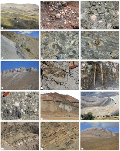
Figure 12. Setting of Upper Cretaceous pelagic carbonates, sandstone-mudstone turbidites and polymict debris-flow deposits within the volcanic-sedimentary melange. (a) Measured log; (b) Outcrop profile; (c) Tectonic model, showing a small basin that was later imbricated with the volcanic-sedimentary melange. These gravity deposits are interpreted as the remains of one of a number of small, perched basin within the Cretaceous accretionary wedge. These sediments provide evidence of a Late Cretaceous age of accretionary melange formation.
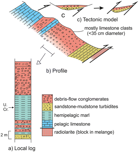
Figure 13. Rock classification diagram utilising relatively immobile elements (template according to Pearce, Citation1996). All of the volcanic rocks analysed plot in the basalt and alkali basalt fields.
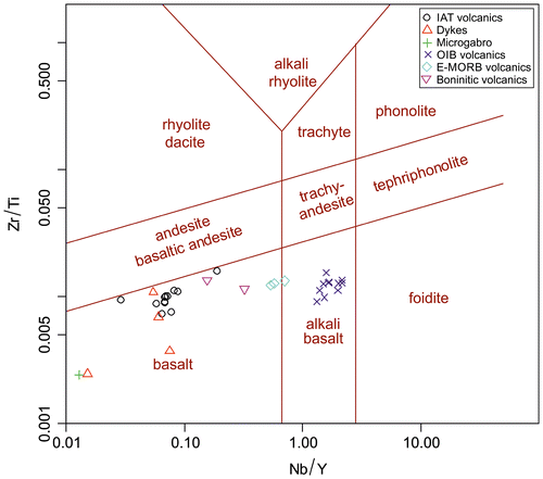
Figure 14. N-MORB-normalised rare earth element plots showing the different groups of basaltic rocks identified. Normalising values from Sun and McDonough (Citationl989). See text for explanation.
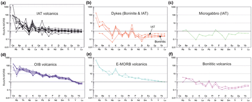
Figure 15. Chondrite-normalised rare earth element plots showing the different groups of basaltic rocks identified. Normalising values from Sun and McDonough (Citationl989). See text for explanation.
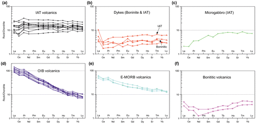
Figure 16. Cross-section showing 1 – Slices of internally coherent ophiolitic rocks (lefthand side); 2 – Volcanic-sedimentary melange, including dismembered blocks of ophiolitic rocks; 3 – Dismembered thrust sheet of Upper Cretaceous-Palaeocene? Carbonate rocks (e.g. Talas Dağı) which is correlated with the Eurasian margin succession; 4 – Unconformably overlying Oligo–Miocene succession. See Figure for location.
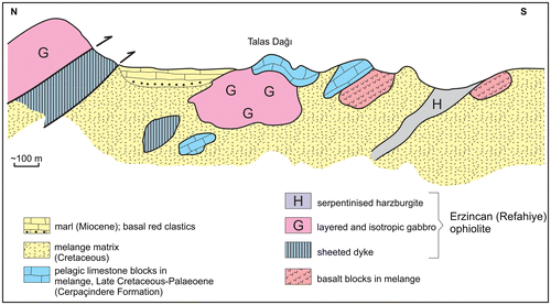
Figure 17. Outline tectonic map of the Karadağ ophiolite and related units (see Figure ). The Karadağ ophiolite includes well-preserved upper crustal rocks (layered and isotropic gabbros and basaltic extrusives). Sheeted dykes are locally exposed as small slices associated with ophiolitic gabbro (in the central south of the outcrop). The ophiolitic rocks are structurally overlain by Jurassic–Cretaceous sedimentary and volcanic rocks related to the Eurasian continental margin (compiled from Konak et al., Citation2001; Konak & Hakyemez, Citation2008b; Parlak, Çolakoğlu, et al., Citation2013 and this study). For section A–B see Figure (b).
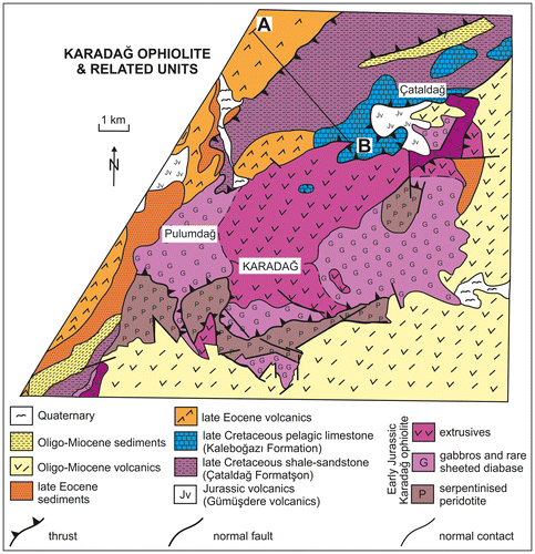
Figure 18. Outline tectonic map of the Kırdağ area. A large thrust sheet of dismembered serpentinised ultramafic rock is structurally underlain by a tectonic slice complex, which is made up of dismembered upper crustal ophiolitic rocks, intersliced with volcanic-sedimentary and ophiolitic melange and Eurasian margin-derived sediments. The ophiolitic gabbro is cut by a tonalite intrusion, radiometrically dated as Early Jurassic. Late Cretaceous pelagic carbonates and Late Palaeocene?–Early Eocene terrigenous gravity flows structurally underlie the peridotite nappe. The area also hosts a metamorphic melange (undated) with blocks of HP-LT lithologies and an underlying slice of metaterrigenous sandstone (also undated) (see Figure ; compiled from Konak & Hakyemez, Citation2008a; Konak & Sümengen (Citation2009); Parlak, Çolakoğlu, et al., Citation2013 and this study).
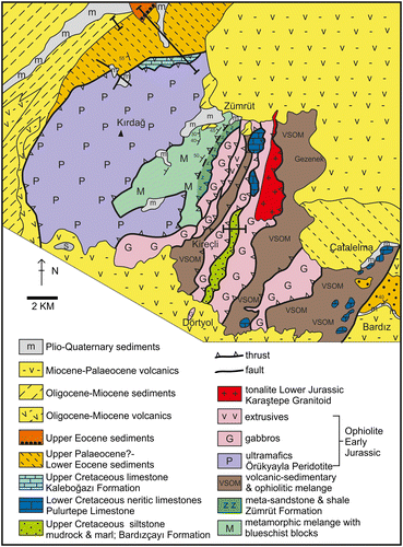
Figure 19. Outline tectonic map and cross-section of the area SW of Erzincan. A thrust sheet of plutonic rocks belonging to the Refahiye Ophiolite is structurally underlain by an unusual unit that is made up of metamorphic rocks (e.g. marble and schist), cut by swarms of diabase dykes. Ophiolitic gabbro and the volcanic-sedimentary melange are thrust over Late Cretaceous–Eocene arc-related volcanic rocks (Karadağ Massif) further south (see Figure ; compiled from Tarhan (Citation2008), Rice et al. (Citation2006) and this study).
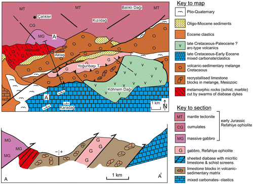
Figure 20. Selected cathodoluminesence (CL) images of dated zircon crystals. The textures are typical of igneous zircons. Homogenous areas of zircon crystals were selected for analysis, while rims were avoided. Scale bars are 50 μm long unless otherwise indicated. See text for explanation.
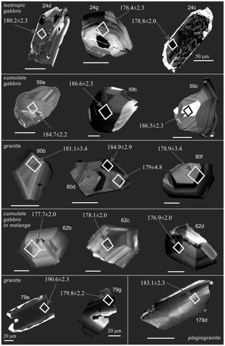
Figure 21. Key structural relationships in the Erzincan area; (a) Serpentinised peridotite cut by isolated sheared diabase dykes and later thrust over serpentinite melange; NW of Erzincan; (b) Serpentinised peridotite cut by isolated sheared diabase dykes; this was then intercalated with ophiolitic gabbro and thrust over the volcanic-sedimentary and ophiolitic melange; N of Erzincan; (c) Volcanic-sedimentary and ophiolitic melange covered unconformably by Eocene basinal sediments and, in turn, by Plio–Quaternary clastic sediments; NW of Erzincan; (d) Volcanic-sedimentary and ophiolitic melange unconformably overlain by Eocene marine sediments, including channellised facies near the base. NE of Erzincan, see Figure for locations of sections.
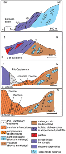
Figure 22. Isochron plots of age data for the dismembered and ordered ophiolites. EZ-11-62: Gabbro cumulates from a gabbroic slice within ophiolitic melange (i.e. dismembered ophiolite) in the Horasan area; EZ-11-79 and 80: Two samples from a tonalite body (Karataştepe Granitoid) that cuts isotropic ophiolitic gabbro (i.e. dismembered ophiolite) in the Kırdağ area; EZ-11-24: Gabbro cumulate from the Karadağ Ophiolite (i.e. ordered ophiolite); EZ-11-59: Gabbro cumulate from the Kop Dağ Ophiolite (ordered ophiolite), W of Aşkale); EZ-11-179: Plagiogranite cutting the sheeted dykes of the Refahiye Ophiolite, W of Erzincan (included with the ordered ophiolite although it comes from a thrust sheet beneath the main ophiolite body). The results show that all of the ophiolitic rocks and the crosscutting tonalite crystallised during Early Jurassic time. See text for further explanation.
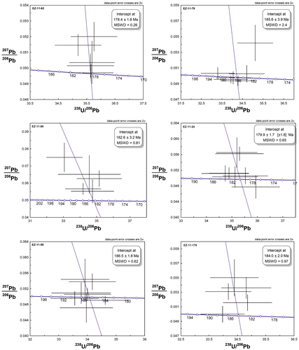
Figure 23. Outline tectonic map showing the relationship of the Refahiye ophiolite to adjacent units (Figure ) (Compiled from MTA, Citation2002 and this study.). Serpentinised peridotite, cut by diabase dykes, is overthrust by a large sheet of Jurassic metamelange, which includes a large marble unit. The area is transected by the North Anatolian Transform Fault in the northeast. The map highlights the westward extension of the Refahiye Ophiolite and the presence of metamorphic melange (locally dated as Jurassic), intersliced with ophiolitic rocks (see Topuz et al., Citation2013).
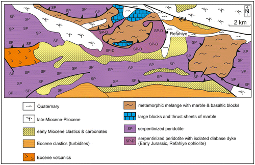
Figure 24. Cross-section of the Kırdağ serpentinised peridotite nappe in relation to underlying units. In the north, a dismembered ophiolite is thrust over Upper Cretaceous pelagic carbonates and Palaeocene?–Early Eocene terrigenous gravity flows (see Figure (b)). To the south, the ophiolite is underlain by two contrasting metamorphic units, first, a melange with blocks of HP-LT metamorphic rocks and secondly, a slice of sandstone turbidites. The melange with HP-LT metamorphic rocks includes lenses of metaclastic sediments and sheared ultramafic rocks (see Figure ; compiled from Konak & Hakyemez, Citation2008a; Konak & Sümengen, Citation2009; Parlak, Çolakoğlu, Citation2013 and this study).
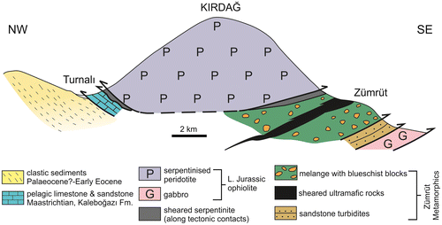
Figure 25. Cross-sections of Eurasian margin-derived sedimentary rocks that were emplaced over the oceanic rocks of the suture zone. (a) Volcaniclastic sandstones and shales passing upwards into a thick, folded sequence of Upper Cretaceous pelagic carbonates. Way-up and structural evidence suggest that this sequence forms the upper limb of a large-scale ~N-facing recumbent syncline, consistent with ~N-directed thrusting. In the NW, the sequence is thrust over red conglomerates (Oligocene?), with derived clasts of Late Cretaceous limestone. The red conglomerates are, in turn, thrust over the volcanic-sedimentary and ophiolitic melange. Şahvalet area, near Aziziye; see Figure ); (b) Upper Cretaceous volcaniclastic turbidites passing upwards into Upper Cretaceous redeposited carbonates (above a minor shear zone), which are thrust over basaltic extrusives of the Karadağ ophiolite; N margin of Karadağ massif; see Figure .
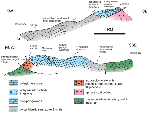
Figure 26. Regional reference successions compared to successions measured during this work. (a) Distal (southerly) Pontide continental margin; (b) Proximal (northerly) Pontide continental margin (a–b reference successions; see e.g. Okay & Şahintürk, Citationl997a); (c–e) Slices of Eurasian-derived sediments from within the Pontide suture zone. Accretionary melange was emplaced over the distal (southerly) margin of Eurasia during the Late Cretaceous, while sedimentation continued further north into Early Eocene time.
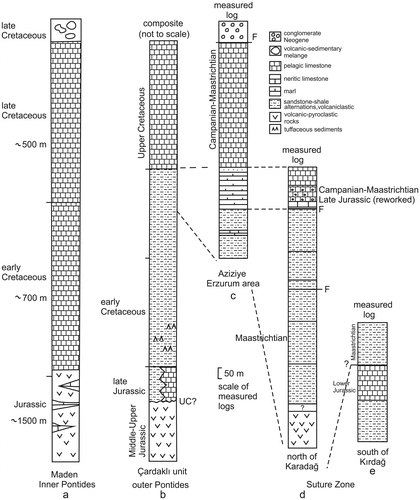
Figure 27. Photomicrographs of Upper Cretaceous–Eocene sandstones from the suture zone and the adjacent Eurasian continental margin. (a) Redeposited carbonate (packstone) with neritic bioclast fragments (e.g. bivalves, calcareous algae, echinoderm plates) in the highest levels of the Eurasian margin succession (half-polarised light); 5 km NW of Otlukbeli (SW of Bayburt); see Figure (40°01′38.8″N, 39°55′47.4″E); (b) Sublitharenite (plane-polarised light); largely quartz, altered basalt and basaltic glass, plus clinopyroxene, with a calcite spar cement (Bardızçayı Formation, near Doşkaya, Kırdağ area; see Figure ; 40°29′26.6″N, 42°13′44.8″E); (c) Subarkose (crossed nicols). Feldspar (zoned plagioclase) in a matrix of volcaniclastic siltstone, including rare clinopyroxene and hornblende; Upper Cretaceous (Bardızçayı Formation); main road south of Zümrüt (to Çatalelma), Kırdağ area; see Figure ; 40°31′21.7″N, 42°14′49.0″E); (d) Litharenite (plane-polarised light). Upper Cretaceous volcanogenic sandstone (plane-polarised light); N of Karadağ; abundant basaltic and feldspar (plagioclase grains; near Başaklı köy; see Figure (b); 40°27′24.8″N, 41°47′46.0″E); (e) Litharenite (plane-polarised light). Upper Cretaceous volcanogenic sandstone, rich in basalt and plagioclase, together with some clinopyroxene and hornblende; 4 km W of Akören köy, Horasan area (see Figure , 40°15′34.5″N, 42°12′39.1″E); (f) Litharenite (crossed nicols). Upper Cretaceous volcanogenic sandstone, compositionally similar to e; see Figure for location; NW of Aziziye; near 39°48′55.6″N, 41°22′29.3″E); (g) Litharenite (serpentinite-rich, coarse, poorly sorted sandstone (half crossed nicols); c. 3.5 km NW of Dönertaş, Horasan area (see Figure ); 40°14′36.5″N, 42°06′54.6″E). (h) As g, serpentinite grains in calcite spar cement (crossed nicols); (i) Subarkose (crossed nicols); common grains of feldspar, altered basalt and quartz with a calcite spar cement; near base of Eocene sequence, 3000 m of Ağılözü, NW of Erzincan (39°52′52.1″N, 39°19′40.5″E); (j) Litharenite (half-polarised light); basaltic grains with plagioclase microphenocrysts in matrix of devitrified glass; calcite spar cement; Middle Eocene; NW of Bozdoğan; Olur area (see Figure , 39°53′09.6″N, 39°27′23.1″E); (k) Litharenite (half-polarised light); including silicic volcanic grains; Upper Palaeocene?–Eocene succession that structurally underlies the Kırdağ ophiolite (see Figure (b); SW of Başaklı köy; 40°34′59.3″N, 42°08′49.2″E); (l) Litharenite (tuff); volcanic glass (tephra) within relatively deep-marine foraminiferal sediments (half-polarised light); Middle Eocene; NW of Bozdoğan, Olur area (see Figure ); 40°53′06.1″N, 42°06′02.7″E). Key to grains: Ba, Basalt; Ca, Calcite; C, Chlorite (altered basic volcanic); F, Feldspar; Fo, Planktic foraminifer; Py, Clinopyroxene; Q, Quartz; R, Rhyodacite; S, Serpentinite; T, Tephra (volcanic glass).
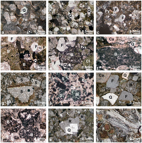
Table 1. Summary of the calcareous microfossils identified, as referred to in the text, together with geographical coordinates.
Figure 28(A). Micopalaeontological evidence. Mesozoic microfossils (benthic foraminifers, calpionellids and algae) (a) Agerina martana (Farinacci), sample 52; (b) Involutina liassica (Jones), sample 52; (a–b) Şahvalet area; Early Jurassic; (c) Calpionella alpina Lorenz (Ca), Crassicollaria sp. (C), sample 125; (d) ‘Tubiphytes’ morronensis Crescenti, sample 184; (a–d) Karadağ area; Late Tithonian; (e) Labyrinthina mirabilis Weynschenk, sample 194; (f) Protopeneroplis striata Weynschenk, sample 193, Erzincan area, block in melange; Late Jurassic (Late Oxfordian–Early Kimmeridgian). (g) Verneuilina sp., sample 26, Karadağ Massif, Late Tithonian; (h) Salpingoporella cf. S. muehlbergii (Lorenz), sample 19, Kırdağ area; Barremian; (i) Salpingoporella annulata Carozzi, sample 69, Horasan area; Early Cretaceous; (j) Palorbitolina lenticularis (Blumenbach), sample 84, Kırdağ area, late Barremian–early Aptian; (k) Mayncina bulgarica Laug et al., sample 76, Kırdağ area; Early Cretaceous; (l) Actinoporella podolica (Alth), sample 69, Horasan area; Early Cretaceous; (m) Smoutina cruysi Drooger, (n) Sirtina orbitoidiformis Brönnimann & Wirz, (o) Pseudosiderolites vidali (Douville), sample 116, Late Maastrichtian, (m–o), Şahvalet area; near Aziziye; Scale bars: .2 mm.
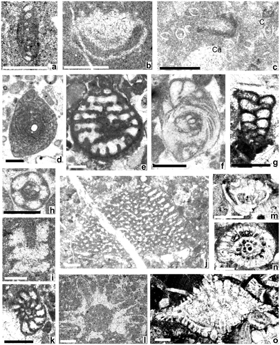
Table 2. Radiolarian ages inferred from the samples studied.
Table 3. (a) and (b) Major, trace element and REE data for basalt, diabase and microgabbro, associated with Early Jurassic ophiolitic rocks of the suture zone (parts A and B). LOI LOI. The samples are basalt except: EZ-11-91A microgabbro dyke in tonalite; EZ-11-21A microgabbro dyke in serpentinite; EZ-11-46 sheeted diabase; EZ-11-95 diabase dyke in serpentinite; EZ-11-23 microgabbro. Locations are listed in Table .
Table 4. Locations where basaltic rocks were collected for chemical analysis.
Table 5. Summary of the chemical data obtained by ion probe analysis. The uncorrected and corrected U–Pb isotopic ratios were used to calculate the Early Jurassic radiometric ages.
Figure 28(B). Micopalaeontological evidence. Late Cretaceous planktic foraminifera and Miocene large foraminifera. (a–b) Hedbergella sp., sample 165, Otlukbeli area, Late Cretaceous; (c) Archaeoglobigerina cretacea (d’Orbigny), sample 112; (d) Schackoina multispinata (Cushman & Wickenden), sample 114; (e) Globotruncanella petaloidea (Gandolfi), sample 58; (c–e) Şahvalet area; near Aziziye; (f) Globotruncana bulloides Vogler, sample 43A; Horasan area; near Yatıksırt); (g) Rugoglobigerina rugosa (Plummer), sample 68; (h) Planoglobulina carseyae (Plummer), sample 68; Horasan area; W of Akören; (i) Globotruncana orientalis El Naggar, sample 111; Şahvalet area; near Aziziye; (j) Rugoglobigerina milamensis Smith & Pessagno, sample 34a; Horasan area; near Kalendere; (k) Globotruncanita pettersi (Gandolfi), sample 68; (l) Racemiguembelina fructicosa (Egger), sample 68; Horasan area; W of Akören; (m) Abatomphalus mayaroensis (Bolli), sample 35A; Horasan area; near Kalendere; (n–p) Miocene benthic foraminifera, n: Operculina complanata (Defrance) (O), Amphistegina lessonii (d’Orbigny) (A), coralline alga (C), sample 175; E of Erzincan, main road sectional o: Borelis sp., sample 88; Şahvalet area; W bank of Aras Çay; p: Miolepidogypsina sp., sample 178; NE of Erzincan; S of Kapılıdağ. Scale bars: .2 mm.
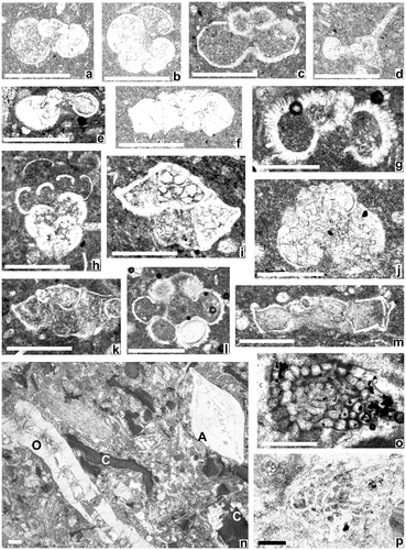
Figure 29. Cross-section and sedimentary log of Jurassic–Cretaceous sedimentary succession within imbricate thrust sheets to the SE of the Kırdağ massif (see Figure for location). In general, Early Cretaceous neritic limestones and siltstones/mudrocks are overlain by Upper Cretaceous volcanogenic siltstone and fine-grained sandstones.
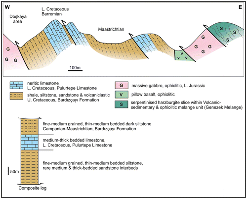
Figure 30. Cross-section showing interslicing of Cretaceous Eurasian margin-related sediments with ophiolitic rocks; Horasan area (see Figure ). The Eurasian margin units are tectonically dismembered, while the intact sequences include interbedded debris-flow deposits.
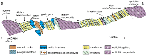
Figure 31. Highest stratigraphical levels of the Eurasian margin carbonate platform and overlying volcanic-sedimentary melange (near Otlukbeli, W of Bayburt; (a) Outline geological map (modified from Bozkuş & Yılmaz, Citationl993); (b) Cross-section A–A′. The highest stratigraphical levels of the platform are dated here as Campanian–Maastrichtian using planktic foraminifera; (c) Dismembered thrust sheet (large block) within the volcanic-sedimentary melange in the SE of the area (B–B′). (see Figure ; compiled from Korkmaz & Baki, Citationl984, Özer, l984 and this study).
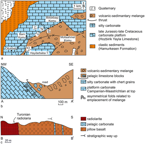
Figure 32. Upper Cretaceous and Cenozoic successions exposed along the northern margin of the Kırdağ massif. Upper: cross-section. The small offset section shows a contrasting relationship several kilometres to the SW where the Lower Eocene succession is unconformably overlain by Oligo-Miocene sediments and volcanics. Lower left, summary logs (1–6) with locations marked on the cross-section above. Data from this study (see Figure for location).
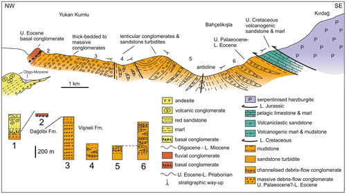
Figure 33. Simplified geological map of a key area of the Eurasian margin to the north of the suture zone, NW of Olur. Left: outline map showing lines of sections; Right: upper, Summary measured log (composite of logs a and b on the map; this study); Right lower, cross-section (marked A–A′ on the map). (U. Eo Upper Eocene; M. Eo. Middle Eocene). An Upper Cretaceous marine, mixed carbonate/volcanogenic succession passes into Upper Palaeocene shallow-water mixed carbonates and clastics. This sequence was transgressed by Middle-Upper Eocene non-marine, shallow-marine and then deeper-marine (marls) sediments. The shelf carbonates are intercalated with basaltic extrusions (see Figure ; compiled from Konak & Hakyemez, Citation2008a and this study; see also Bozkuş, Citationl992a, Citation1992b).
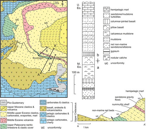
Figure 34. Relationship of the Munzur carbonate platform (part of the Taurides) to the suture zone in the southwest of the area studied. For the line of the main cross-section see Figure . The small cross-section (above, center) shows an outcrop on strike to the E where basalt and cherty pelagic limestone are also exposed. The Karadağ Massif is interpreted as part of the Eurasian continental margin, which was imbricated with volcanic-sedimentary melange during collision-related out-of-sequence thrusting.
Figure 35. Influence of Plio–Quaternary strike-slip related to the North Anatolian Transform Fault, as seen along the NE margin of the ophiolite in the Erzincan area. Ophiolitic peridotite is juxtaposed with the volcanic-sedimentary and ophiolitic melange by a strike-slip fault. Another strike-slip fault separates the melange from the Eurasian carbonate platform to the north. The Oligocene–Miocene cover of both the ophiolite and the melange was folded (Late Miocene?) prior to Plio–Quaternary fault displacement.
Figure 36. Tectono-stratigraphic comparison. (a) Central Pontides (see Figure for line of section). One important unit, the Upper Cretaceous arc apron/forearc basin sediments (Yapraklı Formation) is exposed ~20 km west of the section, while the largest ophiolite outcrop (type Kızılırmak ophiolite) is exposed 50 km northeast of the line of section; (b) Eastern Pontides (see Figure for line of section). This section is representative of the western part of the Eastern Pontide region (around Erzincan), where the oceanic units dip below Eurasian continental margin units. In contrast, the structure of more easterly areas of the Eastern Pontide was strongly influenced by post-collisional northward thrusting. (a–b) Modified after Rice et al. (Citation2006) (c) Lesser Caucasus. ci, well-documented example of imbricate thrust belt within the western exposure of the Sevan–Akera suture zone (simplified from Hässig et al., Citation2013); cii, isolated klippen of oceanic rocks ~50 km SW of the main Sevan–Akera suture zone; thrust over the northernmost outcrop of the South Armenian crustal unit (simplified from Sosson et al., Citation2010). See text for discussion.
Figure 37. Emplacement of accretionary melange over the collapsed southern margin of Eurasia represented by the Pontide carbonate platform (near Otlukbeli, SW of Bayburt; see Figure for location). The uppermost levels of the platform comprise pelagic and redeposited carbonates that were are dated as Campanian–Maastrichtian during this study (see Figure ). The platform succession terminates with siltstone/fine-grained sandstone turbidites with reworked Early Cretaceous benthic foraminifera. Folds in the carbonate platform indicate top-N displacement. The lowest levels of the melange contain blocks of lithologies that are similar to those exposed in the highest levels of the platform (i.e. Campanian–Maastrichtian-aged pelagic and silty redeposited carbonates).
Figure 38. Mid- to Late Eocene post-collisional basin located in the northeast (Olur area; see Figure ). The basin records subsidence soon after the final ocean basin suturing. More distal successions are exposed along the Black Sea coast, suggesting that the Eastern Black Sea basin also experienced a rift event during Mid-Late Eocene time. Similar basins of this age developed throughout the Pontides and the Lesser Caucasus. See text for discussion.
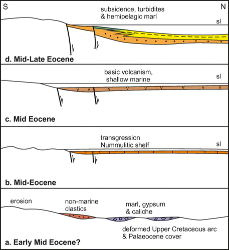
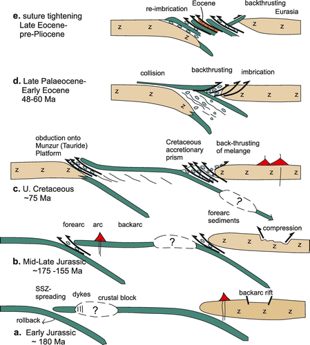
Figure 39. Three alternative models for the Early Jurassic of SSZ oceanic crust. Option b (favoured) is developed in Figure . (a) Single subduction zone dipping beneath the Pontide continental margin. ai, The ophiolite forms by SSZ spreading, coupled with rifting (extension) of the Eurasian margin. The dyke swarms cutting metasediments (beneath the Refahiye ophiolite; see Figure ) are explained by initiation of spreading along the Eurasian margin; aii, A colliding crustal block (continental fragments or igneous seamount) is invoked to explain the well-documented closure of the backarc rift and deformation of the Eurasian continental margin during the Late Jurassic; (b) Two N-dipping subduction zones, one oceanic and one adjacent to the Pontide margin. Older oceanic crust (Palaeotethys) is subducted to create the Jurassic backarc rift and arc. bi, The Early Jurassic oceanic crust is generated by SSZ spreading in a more oceanic setting. A crustal block is again invoked to explain the origin of the dyke swarms (as in ai); bii, the inferred continental fragment collides with the Eurasian margin leading to closure of the backarc rift; (c) Single S-dipping subduction zone. ci, Intra-oceanic subduction possibly initiates along the margin of a crustal block. Slab-pull might help explain the Jurassic continental margin magmatism (but not its subduction-related chemical affinities). cii, Southward subduction culminates in collision and emplacement over the Eurasian margin during the Late Cretaceous. Some accretionary melange was indeed emplaced over the Eurasian margin during the Late Cretaceous but evidence for large-scale ophiolite obduction is absent. Each of the above models has some pros and cons as discussed in the text.
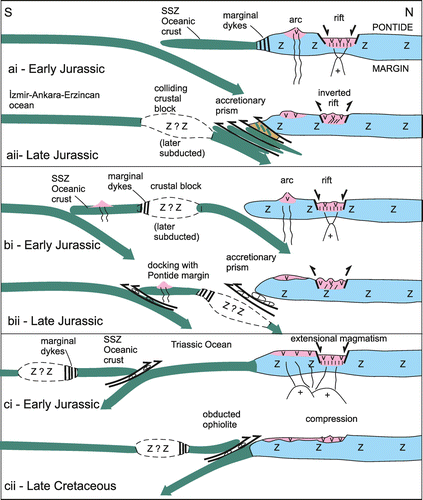
Figure 40. Proposed double subduction zone tectonic model for the Mesozoic-Palaeogene development of the suture zone in the Eastern Pontides, E Turkey. See text for explanation.