Figures & data
Figure 1. Simplified neotectonic and relief maps of Turkey and the surrounding area (compiled with Yiğitbas, Elmas, Sefunç, and Özer, Citation2004) and CGIAR-CSI GeoPortal, Citation2012). Abbreviations: SBT, Southern Black Sea Thrust; NAFZ, North Anatolian Fault Zone; NEAFZ, Northeast Anatolian Fault Zone; WAEP, West Anatolia Extensional Province; EAFZ, East Anatolian Fault Zone; DSFZ, Dead Sea Fault Zone.
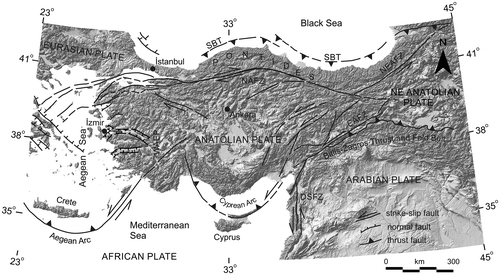
Figure 2. Simplified tectonic map of Turkey and surrounding regions, showing the main sutures and continental fragments (modified after Tunç et al., Citation2012) and the location of the study area (see rectangle)
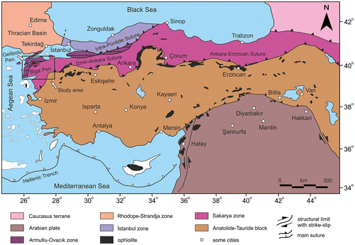
Figure 3. Geological map of the Gelibolu (modified after Dönmez, Akçay, Duru, Ilgar, and Pehlivan Citation2008) and Ilgar et al., Citation2008) and Biga peninsulas (modified after Duru et al., Citation2012).
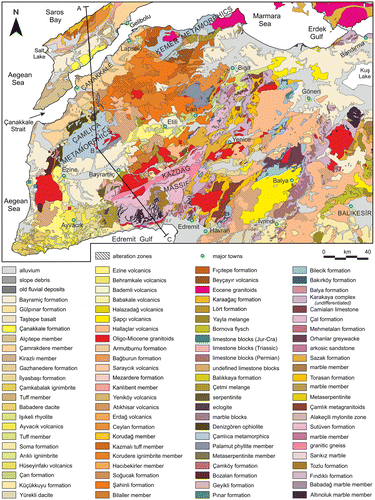
Figure 4. A simplified geological cross-section along A–B and B–C lines shown in Figure . Note that vertical axis of the cross-section was exaggerated and an approximate topography was used for the illustration.
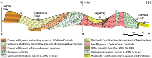
Figure 5. Topographic map of the study area showing the distributions of the epicentre of the earthquakes with magnitudes of M ≥ 4. The sizes of the stars are proportional to the earthquake magnitudes. The overlapped active faults in Biga Peninsula are modified after Duru et al. (Citation2012). The overlapped faults in Gelibolu Peninsula are modified after Yaltırak et al. (Citation2000). Black lines show coastline. Abbreviations: KF, Kestanbol Fault; EVF, Evciler Fault; ÇBFZ, Çan-Biga fault zone; SF, Sinekli Fault; SAF, Sarıköy Fault; YGF, Yenice-Gönen Fault; PF, Pazarköy Fault; EF, Edincik Fault; HBFZ, Havran–Balıkesir fault zone; OF, Ovacık Fault; BF, Bekten Fault; MFZ, Manyas fault zone; EFZ, Edremit fault zone; ATF, Anafartalar thrust fault; GF, Ganos Fault.
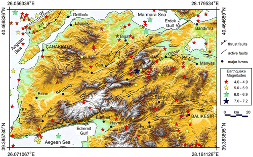
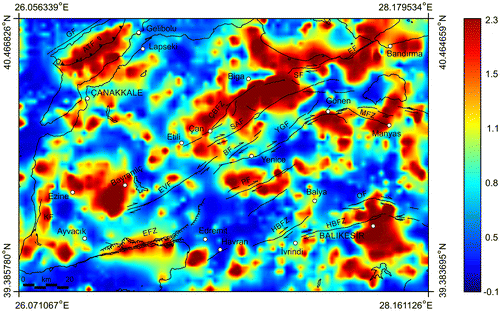
Figure 6. Complete Bouguer gravity anomaly map of the study area. The overlapped active faults in Biga Peninsula are modified after Duru et al. (Citation2012). The overlapped faults in Gelibolu Peninsula are modified after Yaltırak et al. (Citation2000). Abbreviations used for the faults are given in Figure .
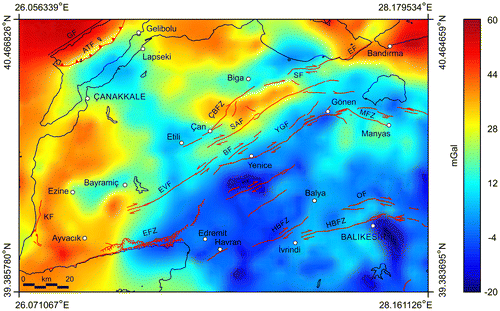
Table 1. Model parameters of three prismatic bodies used for the test simulations.
Figure 7. (a) General plan view of three prismatic theoretical model bodies used for the synthetic simulations. (b) Synthetically generated gravity data-set consisting of the anomalies caused by three-dimensional prismatic source bodies shown in (a), Contour interval: 0.4 mGal.
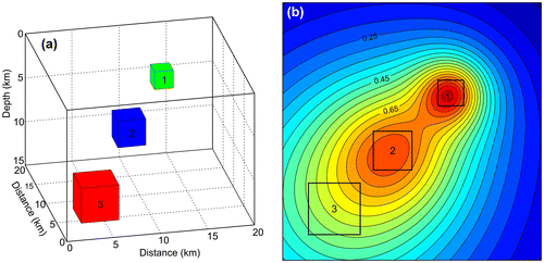
Figure 8. The results of the synthetic simulations obtained by regional/residual separation algorithms. Contour interval: 0.04 mGal. (a) Regional background computed by using FEM. (b) Residual anomaly map computed by using FEM. (c) Regional background computed by using second-order polynomial fitting procedure. (d) Residual anomaly map computed by using second-order polynomial fitting procedure. (e) Regional background computed by using third-order polynomial fitting procedure. (f) Residual anomaly map computed by using third-order polynomial fitting procedure.
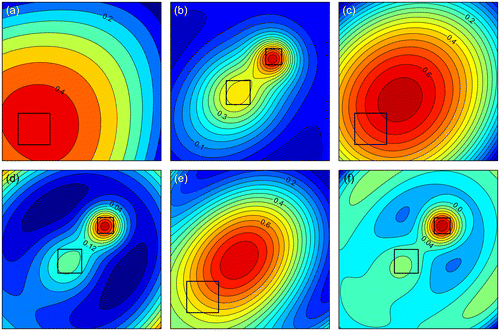
Figure 9. Regional gravity background of the study area computed by FEM based on the use of element shape functions. Contour interval: 4 mGal.
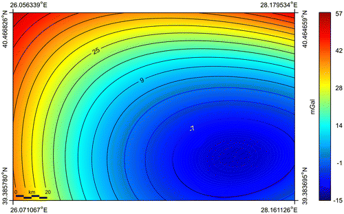
Figure 10. Residual gravity anomaly map of the study area. The overlapped active faults in Biga Peninsula are modified after Duru et al. (Citation2012). The overlapped faults in Gelibolu Peninsula are modified after Yaltırak et al. (Citation2000). Black lines show coastline. Abbreviations used for the faults are given in Figure .
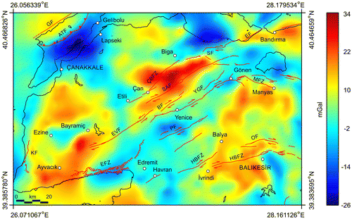
Figure 11. THD anomaly map of the data shown in Figure . The overlapped active faults in Biga Peninsula are modified after Duru et al. (Citation2012). The overlapped faults in Gelibolu Peninsula are modified after Yaltırak et al. (Citation2000). Black lines show coastline. Abbreviations used for the faults are given in Figure .
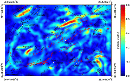
Figure 12. Maxspot map showing the locations of the maximum horizontal gradient amplitudes. The overlapped active faults in Biga Peninsula are modified after Duru et al. (Citation2012). The overlapped faults in Gelibolu Peninsula are modified after Yaltırak et al. (Citation2000). Black lines show coastline. Abbreviations used for the faults are given in Figure .
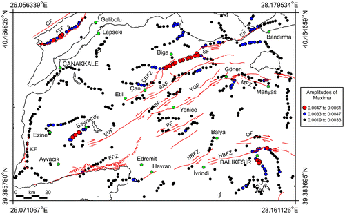
Figure 13. Profile curvature anomaly map of the data shown in Figure . The overlapped active faults in Biga Peninsula are modified after Duru et al. (Citation2012). The overlapped faults in Gelibolu Peninsula are modified after Yaltırak et al. (Citation2000). Black lines show coastline. Abbreviations used for the faults are given in Figure .
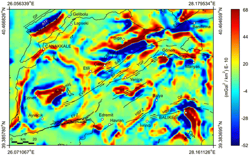
Figure 14. NFG depth slice map of the data shown in Figure . The overlapped active faults in Biga Peninsula are modified after Duru et al. (Citation2012). The overlapped faults in Gelibolu Peninsula are modified after Yaltırak et al. (Citation2000). Black lines show coastline. Abbreviations used for the faults are given in Figure .