Figures & data
Figure 1. Generalised geological map of western Turkey, including major rock units and structural elements. The inset shows the simplified tectonic map of the Aegean region including major tectonic units of western Turkey. Structural elements were adopted from Yılmaz et al. (Citation2000), Erkül et al. (Citation2005), Çemen, Catlos, Göğüş, and Özerdem (Citation2006), Thomson and Ring (Citation2006), Ersoy et al. (Citation2010), Öner and Dilek (Citation2011), Karaoğlu and Helvacı (Citation2012), Ersoy, Çemen, Helvacı, and Billor (Citation2014) and our own data. Compiled age data of volcanic units are from Ersoy et al. (Citation2014). Lower hemisphere equal-area stereographic projections of lineation patterns measured from footwall rocks of the Menderes Massif (black circle) and mylonitic rocks in the syn-extensional plutons (red square). İBTZ: İzmir-Balıkesir transfer zone. UMTZ: Uşak-Muğla transfer zone.
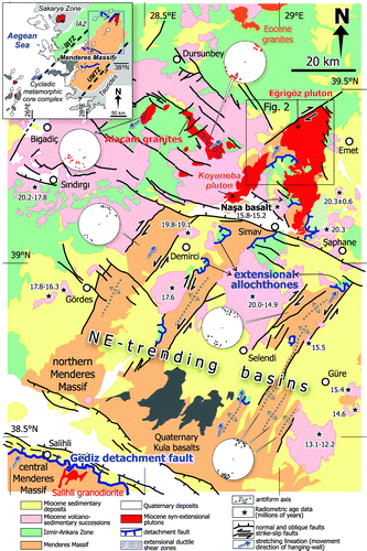
Figure 2. Geological map of the Eğrigöz region. Map coordinates are Universal Transverse Mercator (UTM) grid system. Boundaries of rock units are after Akdeniz and Konak (Citation1979). Numbers in blue circles refer to fold data shown in Figure . Location of the Simav detachment fault (SDF) was partly adopted from Ring and Collins (Citation2005).
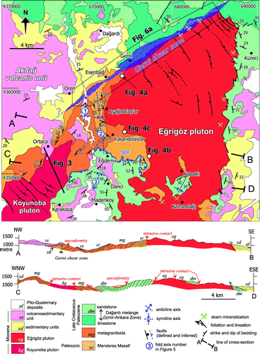
Table 1. Summary of geochronological data from the extensional Simav detachment, syn-extensional plutons and surrounding basin deposits associated with the northern Menderes Metamorphic Core Complex.
Figure 3. A geological cross section showing structural characteristics of the Koyunoba pluton and the surrounding units. Western contact of the pluton with metagranites is formed by microgranites and leucocratic dykes. Intrusive contact on the eastern margin of the Koyunoba pluton is sharp with hornfelsic clastic rocks of the Dağardı Mélange. Low-angle brittle faults and associated cataclastic rocks occur on the western and eastern margins of the Koyunoba pluton. Note that the Miocene fluvial and volcaniclastic rocks of the Akdağ volcanic unit overlie the low-angle brittle faults. See Figure for location of the cross section.
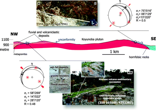
Figure 4. (a) A geological cross section showing lithological characteristics of the metamorphic rocks forming the Menderes Massif and their contact relationship with the Eğrigöz pluton. Metagranites, augen orthogneisses, garnet mica schists and metapegmatoids are structurally alternated to the north-east of Esenbağ. A top-to-the-NE sense of mylonitic shear on the moderately SE-dipping foliation plane is clearly identified within the asymmetric porphyroclasts of orthogneisses and boudined quartz ribbons of the mica schists. Towards the western contact of the Eğrigöz pluton, metagranites are intruded by a few tens of centimeters wide and almost undeformed leucogranitic dykes. Note the cooling contraction joints within the microgranitic margin of the Eğrigöz pluton at the sharp contact with metagranite, suggesting that the metagranitic host rock was cold during emplacement of the pluton. (b) Assimilated orthogneiss within the equigranular granite of the Eğrigöz pluton. (c) Sharp contact between metagranites and the intruding Eğrigöz pluton that includes a host rock fragment. See Figure for location of figures.
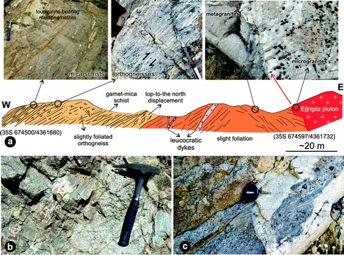
Table 2. Stress tensor results of brittle faults measured from plutons and surrounding units.
Figure 5. Lower hemisphere equal-area stereographic projections of lineation patterns and pole to foliation and bedding planes measured from lower and upper plate rocks. Density contour plots indicate the percent of data per 1% area. Grid interval is 10°. n: number of measurements (black dots on stereoplots). Each contour interval, starting from 0%, is 2% per 1% area. Location of stereoplots 1, 2, 3 and 4 is shown in Figure .
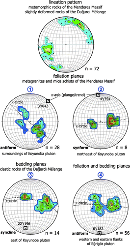
Figure 6. (a) Detailed structural map of the Gerni shear zone north of the Eğrigöz pluton including stereoplots of foliation/lineation data from the mylonitic shear zone and the overprinting brittle fault sets. Refer to Figure for location of fault sites. (b) Brittlely deformed contact zone between the Eğrigöz granite and the hornfels mylonites. (c) Strongly brecciated metamorphic slices of the Menderes Massif within the Gerni shear zone, which is unconformably overlain by thick Miocene fluvial sedimentary sequence belonging to the basal parts of the Akdağ volcanic unit. The view is looking towards the north-east. (d) A mesoscopic-scale dextral shear zone associated with the Gerni shear zone, which cut the mica schists of the Menderes Massif. Outcrop view is subhorizontal to the surface ground. hfs: hornfels, ms: mica-schist, mrb: marble, MM: Menderes Massif, mgr: metagranite, ms: mica schist, mpg: metapegmatoids, DM: Dağardı Mélange, cs: clastic sediments, lst: recrystallised limestone, Mvss: Miocene volcano-sedimentary succession, Qd: Quaternary deposits.
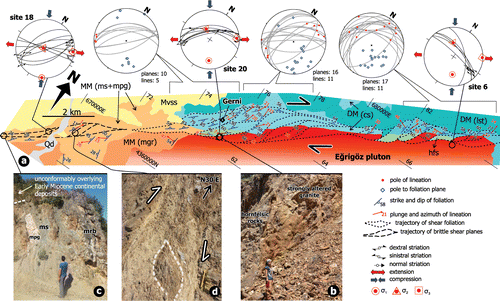
Figure 7. Photomicrographs of granite mylonites and ultramylonites forming the Gerni shear zone. (a) S–C-type shear bands and asymmetrical feldspar porphyroclasts. S-planes are defined by smeared out biotite and sericite trails oblique to the C-planes. Note the similarity of deformation patterns outlined by trajectory of foliation planes to those plotted on the structural map in Figure (a). (b) Mantled porphyroclasts enclosed by biotite trails and obliquely oriented, dynamically recrystallised quartz grains. (c) C′-type shear bands well defined by truncated biotite ribbons. (d) Oblique quartz grain-shape foliation and isoclinal folds in quartz aggregates. (e) Microfaults with normal component overprinting the mylonitic foliation. (f) A truncated biotite fish confined between C′-type shear planes. (g) A brittlely fractured, relatively large δ-type quartz porphyroclast with stair stepping in ultramylonites. (h) Bulging recrystallisation (BLG) of quartz grains in granite mylonites (i) Polycrystalline quartz grains formed by subgrain rotation recrystallisation (SGR). All kinematic indicators display normal-dextral shear sense. Crossed polarised light except for Figure (e). Sections are parallel to the mineral lineation and normal to the foliation. qtz: quartz, bio: biotite, fsp: feldspar.
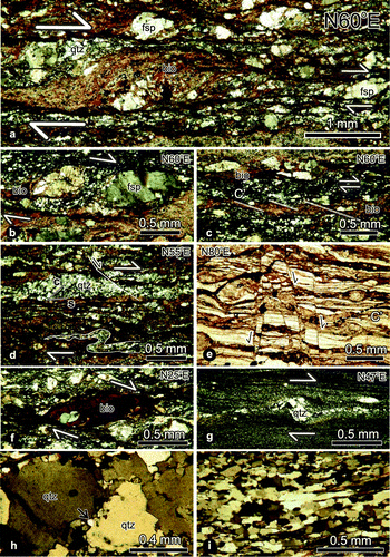
Figure 8. (a) Schmidt lower hemisphere equal-area projections of fault-slip data and principal stress directions from brittle faults in the Eğrigöz region. Refer to Table for fault-slip measurements. Numbers on the upper left of stereoplots correspond to fault site number. (b) Topographic profiles parallel to the strike of the Gerni shear zone.
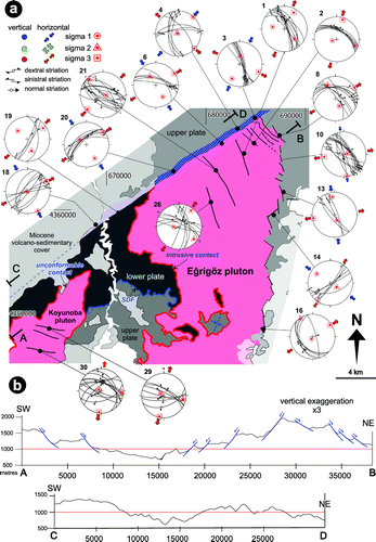
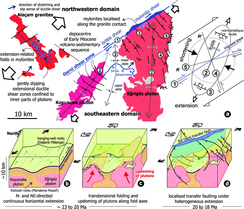
Figure 9. (a) A sketch map summarising the structural elements in two extensional domains separated by the Gerni shear zone in the northern Menderes Massif. The simple shear model has been modified from Waldron (Citation2005). (1) Imposed shear or master fault, (2) folds oblique to the shear direction, (3) normal/oblique-slip faults, (4) synthetic Riedel shear and (5) antithetic Riedel shear. (b–d) A simplified 3D model showing evolutionary model for the major structures described in this study. (b) Early stages of extension caused detachment faulting and folding in the lower and upper plate rocks. (c) Detachment faulting event is followed by updoming of granitoid plutons under the transtensional regime, leading to the development of a series of antiforms with the magmatic core. Low-angle brittle faults formed on the periphery and marginal parts of the plutons were interpreted to have formed during progressive solidification of outer parts of magma above brittle/ductile transition. (d) Ongoing inflation of magma along the hinge lines of antiforms is inferred to have ceased the detachment faulting and initiated the synthetic and antithetic shear zones and transfer zones under the heterogeneous extensional regime.