Figures & data
Table 1. Significant contribution from independent variables to map per-pixel wetland probability.
Figure 1. Example inputs and map results for a part of Central Kalimantan Province (centered approximately at 114°10′24.86″ E, 2°22′53.54″ S): (a) Landsat image with 5–4–3 spectral combination; (b) fit of the model represented by the RMSE; (c) relative elevation of 121.5 km2 catchments; (d) Landsat band 5; (e) false-color r-g-b of (b), (c), and (d); and (f) the initial resulting wetland map as a probability layer where blue is high probability and white low probability.
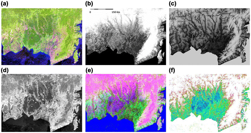
Figure 2. Post-classification steps to refine original wetlands mask from noise. This example is given from Central Kalimantan Province (centered approximately at 114°10′24.86″ E 2°22′53.54″ S); (a) a per-pixel original wetland mask; (b) a map produced by buffering the per-pixel original wetland mask; and (c) a final wetlands map produced by smoothing map b.
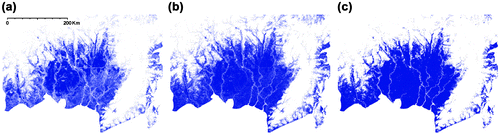
Figure 3. The existing image-interpreted map for part of Central Kalimantan Province centered at approximately 114°10′24.86″ E 2°22′53.54″ S; (a) peatlands distribution map; (b) land cover map; and (c) the aggregated map of (a) and (b) as reference.
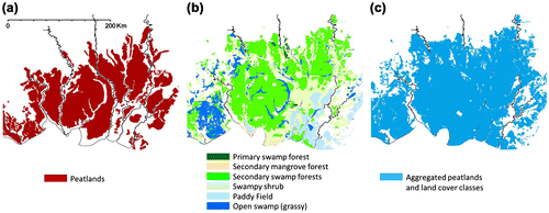
Table 2. Product comparison of Indonesia-wide initial and final wetland map products of this study, with existing image-interpreted maps.
Figure 4. (a) The permanent sample plot (PSP) of NFI data for Sumatra over the Sumatra wetlands; (b) the PSPs of NFI data for Kalimantan over the Kalimantan wetland. The final wetland product is in blue, PSPs with wetland category are in green, and PSPs with non-wetland category (dry-land) are in red.
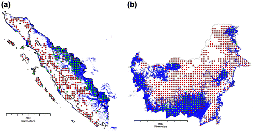
Table 3. Product comparison of original wetlands mask, final wetlands map, available image-interpreted map, and the NFI field plots of Sumatra and Kalimantan.
Figure 5. The map for agreement/disagreement for example inland wetlands in West Papua Province (centered at 138°59′30.02″ E 3°10′50.18″ S) on the left, and riparian wetlands in South Sumatra Province (centered at 103°26′20.4″ E 1°56′45.6″ N) on the right; for (a) Landsat image with 5–4–3 spectral band combination and (b) the wetlands/non-wetlands agreement and disagreement.
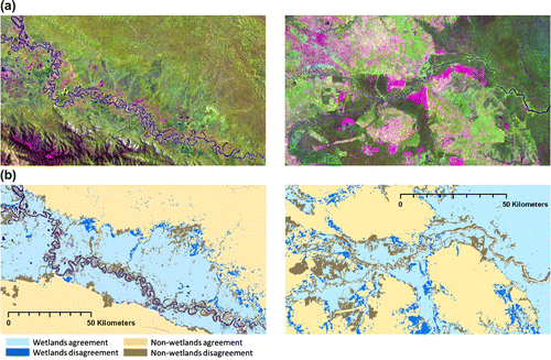
Figure 6. The national wetlands map of Indonesia on the seven largest islands of Indonesia.
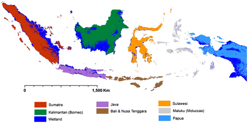
Table 4. The Indonesian wetlands area extent and its distribution per each major island.
Figure 7. The mean and standard deviation of four of the most important independent variables (RMSE, Landsat band 5, relative elevation of 121.5 km2 catchments, and ALOS PALSAR HH + HV polarization) for the original wetlands mask sampled for existing NFI data, for (a) Kalimantan, 105 wetlands plots and 679 non-wetlands plots, and (b) Sumatra, 86 wetlands plots and 280 non-wetlands plots. The t-test summary yielded a p value of <0.000 with 95% confidence with respect to the degrees of freedom of 780 for Kalimantan and 362 for Sumatra.
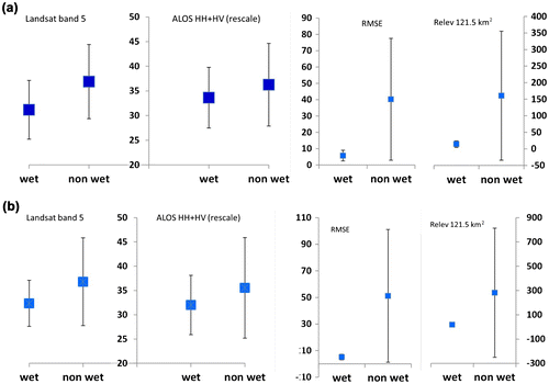
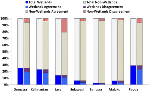
Figure 8. The percentage of wetlands and non-wetlands extent, including agreement/disagreement for each major island group for the derived map and the WI/MoAg/MoF product.