
Figures & data
Figure 1. The study area includes the mainland of Tanzania and comprises eight irrigation zones.
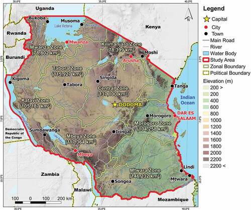
Table 1. Scale and its description (Saaty Citation1977).
Table 2. Random index (RI) table (Saaty Citation1994).
Table 3. List of criteria used for the land suitability assessment and their sources.
Table 4. Weighting factors for the paddy field suitability (rainfed condition and irrigation priority).
Figure 2. Criteria used in the land suitability analysis. (a) Precipitation, (b) Topographic Wetness Index, (c) Slope, (d) Soil Type, (e) Soil Drainage, (f) Temperature, (g) Land Use, (h), Soil pH, (i) Elevation, (j) Soil Depth, (k) Soil Organic Carbon.
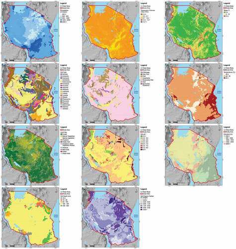
Table 5. List of criteria and subcriteria used for paddy fields and their scores.
Table 6. Rainfall distribution in the study area.
Table 7. Acreage of land use/cover in the mainland of Tanzania.
Figure 3. Land suitability distribution for paddy fields under the rainfed condition scenario. (a) whole study area (b) within potential agricultural land.
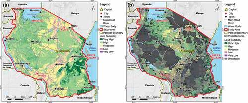
Table 8. Acreage of land suitability classes (rainfed condition) in the mainland of Tanzania.
Table 9. Acreage of land suitability classes (rainfed condition) within potential agricultural land in the mainland of Tanzania.
Figure 4. Percentages of land suitability classes under the (a) rainfed condition and (b) irrigation priority scenarios distributed within the eight irrigation zones.
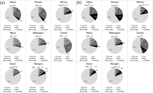
Figure 5. The land suitability distribution for paddy fields under the irrigation priority scenario (a) whole study area (b) within potential agricultural land.
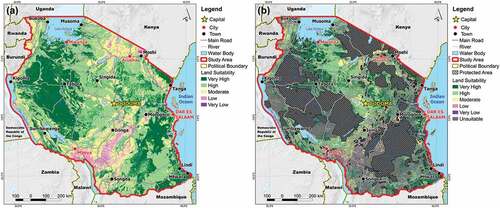
Table 10. Acreage of land suitability classes (irrigation priority) in the mainland of Tanzania.
Table 11. Acreage of land suitability classes (irrigation priority) within potential agricultural land in the mainland of Tanzania.
Data availability statement
Data not available due to legal restrictions. Due to the nature of this research, participants of this study did not agree for their data to be shared publicly, so supporting data is not available.