
Figures & data
Figure 1. The study area. (a) Asian Russia, (b) Primorsky and Khabarovsk Krais.
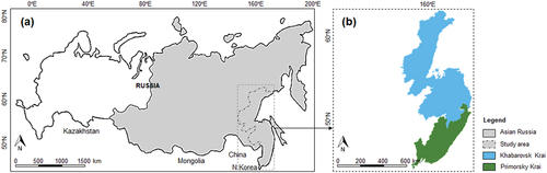
Table 1. Key production industries of the study area.
Figure 2. Data preparation. (a) division of the study area into unit areas, (b) the size of the grid cell, (c) analyzed area.
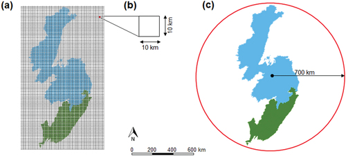
Figure 3. Building accessibility maps from topographic maps: (a) railway, (b) accessibility to the railway, (c) fluvial network, and (d) accessibility to navigational rivers.
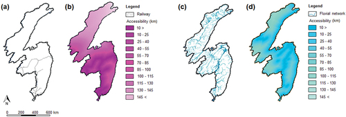
Figure 4. Accessibility maps: (a) systemically important enterprises, (b) fishing and aquatic food production enterprises, (c) railways, (d) aircraft manufacturing enterprises, (e) river and seaports, (f) airports, (g) power generating companies, (h) shipbuilding enterprises, (i) settlements, (j) paved roads, (k) electric power lines, and (l) oil pipelines.
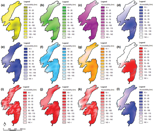
Figure 5. Description of a unit area in the grid-based database.
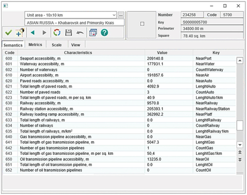
Figure 6. Methodological flowchart. Generation of graded suitability maps from an integrated CA and scenario-based model.
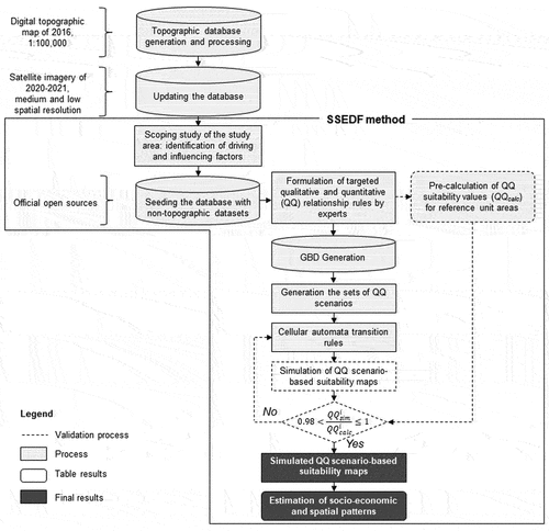
Figure 7. Generation of suitability maps according to defined scenarios. (a) developed railway net – E.1, (b) developed paved road net – E.2, (c) developed river and sea transportation net – E.3, (d) populated areas – A.1, (e) populated areas with developed railway, paved road, river and sea transportation nets – E.1 + E.2 + E.3 + A.1.
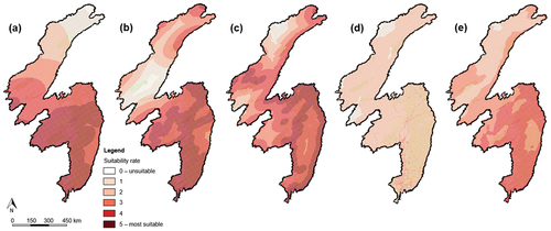
Figure 8. Visualization of graded suitability maps according to PI scenarios. Unit areas that: (a) have access to sea and air transport, shipbuilding clusters, and uninterrupted power supply – D.5 + E.5 + E.6 + B.1, (b) have access to railway and air transport – E.1 + E.5, (c) are well populated and have access to railway and air transport, fishing and aquatic food production enterprises, and uninterrupted power supply – D.1 + E.1 + E.5 + B.1 + A.1, (d) have uninterrupted power supply but no systemically important enterprises – B.1 + (D.7)in, (e) are well populated, have fishing and aquatic food production enterprises, access to railway transport, developed paved road net, and uninterrupted power supply – D.1 + E.1 + E.2 + B.1 + A.1, (f) are well populated and have uninterrupted power supply – B .1 + A.1.
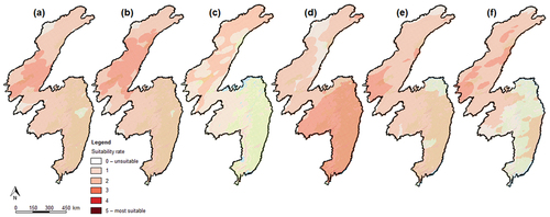
Table 2. Suitability rate of the unit areas identified under PI scenarios.
Figure 9. Inter-regional cluster cooperation. (a) shipbuilding, (b) international transit cargo flows, (c) aircraft manufacturing, (d) fishing and aquatic food production.
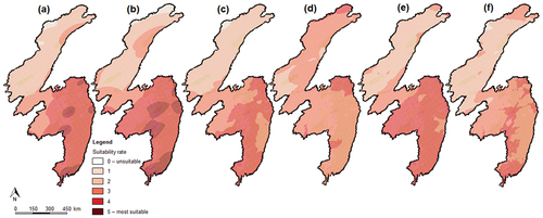
Figure 10. Visualization of graded suitability maps according to RA scenarios. Unit areas that: (a) are well populated and have no access to developed paved road net – A.1 + (E.2)in, (b) are populated and have no uninterrupted power supply – A.1 + (B.1)in, (c) are populated, have access to railway transport and developed paved road net, but have no systemically important enterprises – (D.7)in + E.1 + E.2 + A.1, (d) are populated and have systemically important enterprises – D.7 + A.1 (e) have systemically important enterprises that suffer power supply – D.7 + (B.1)in, (f) are populated and suffer power supply A.1 + (B.1)in.
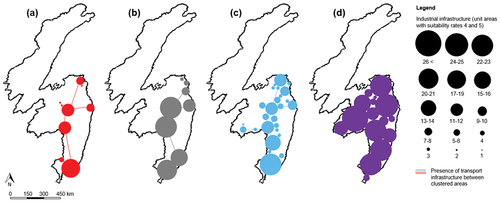
Figure 11. Regional spatial development of populated areas. (a) construction of paved road network, (b) construction of power generating facilities, (c) development of electric power network infrastructure, (d) establishment of backbone enterprises.
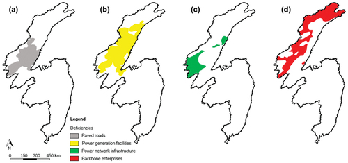
Table 3. Suitability rate of the unit areas identified under RA scenarios.
Table A1. Official open source non-topographic datasets incorporated into project’s GIS database.
Table A2. QQ reference rules. Qualitative socio-economic rules and their subsequent quantitative expressions used as CA transition rules.
Table A3. Thematic maps (layers) developed for the study area.
Table A4. Socio-economic and spatial development scenarios simulated in the research.
Table A5. Validation of the CA transition rules.
Data availability statement
The full data are not available due to legal restrictions. Meanwhile, the participants of this study agreed to share publicly the allowed for open access datasets (Musikhin, Igor; Karpik, Alexander P. (2022): Socio-Economic Development of Asian Russia – datasets for Khabarovsk and Primorsky Krais. figshare. Dataset. https://doi.org/10.6084/m9.figshare.20416599.v1) and the open GIS source software package (Musikhin, Igor (2022): Socio-Economic Development of Asian Russia – open source software package (Cellular automata). figshare. Software. https://doi.org/10.6084/m9.figshare.20417019.v1).