Figures & data
Figure 1 Seasonal variation in total microcystin concentrations in Grand Lake during 2009–2011. Water column and surface samples were collected from nearshore sites (State Park public beaches, the City of Celina Public Works [CPW] water treatment plant intake pipe, and the Ohio Department of Natural Resources [ODNR] office boat ramp) and offshore sites (e.g., near Safety Island). Samples were collected by ODNR, Ohio EPA (OEPA), USGS, and CPW and analyzed by CPW and GreenWater Laboratories (Palatka, FL) using enzyme-linked immunosorbent assays after sonication. Gray-filled diamonds show saturated tests, such that field microcystin concentrations were actually greater than those displayed here. The horizontal dashed lines represent the value for a moderate health alert in recreational waters (20 μg/L; WHO Citation2003).
![Figure 1 Seasonal variation in total microcystin concentrations in Grand Lake during 2009–2011. Water column and surface samples were collected from nearshore sites (State Park public beaches, the City of Celina Public Works [CPW] water treatment plant intake pipe, and the Ohio Department of Natural Resources [ODNR] office boat ramp) and offshore sites (e.g., near Safety Island). Samples were collected by ODNR, Ohio EPA (OEPA), USGS, and CPW and analyzed by CPW and GreenWater Laboratories (Palatka, FL) using enzyme-linked immunosorbent assays after sonication. Gray-filled diamonds show saturated tests, such that field microcystin concentrations were actually greater than those displayed here. The horizontal dashed lines represent the value for a moderate health alert in recreational waters (20 μg/L; WHO Citation2003).](/cms/asset/3d2020fd-2d23-4628-a71d-1317b24f6764/ulrm_a_823469_o_f0001g.gif)
Figure 2 Locations of Grand Lake, its subwatersheds, and the St. Marys State Fish Hatchery (SFH) within Mercer and Auglaize counties, western Ohio. Land use data were extracted from the 2001 National Land Cover Database (Homer et al. Citation2007). Ohio Division of Wildlife (DOW) and Ohio EPA (OEPA; L-1, L-2, and L-3) sites are locations where water samples were collected for phosphorus measurements during 2009–2011, in addition to the south hatchery intake.
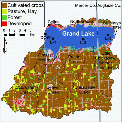
Table 1 Comparisons of animal farming intensity and farm sizes among the state of Ohio, Auglaize and Mercer counties, and the Grand Lake St. Marys watershed during 2007 (GLWWA Citation2008, USDA Citation2009). Animal units (AU) are standardized to the average weight of a beef cow, using conversions listed in the Grand Lake St. Marys/Wabash Watershed Action Plan (GLWWA Citation2008).
Table 2 Comparisons of manure waste production and cropland application rates needed to distribute all manure wastes across Grand Lake St. Marys subwatersheds during 2007. Manure application rates are reported with adjustment for the estimated 70% export of poultry manure. All data were derived from the Grand Lake St. Marys/Wabash Watershed Action Plan (GLWWA Citation2008). All calculations exclude inorganic fertilizers.
Figure 3 Comparisons of (a) total (= All Cattle + Hogs/Pigs + Chickens + Turkeys) animal unit densities in Mercer and Auglaize counties to statewide densities, and (b) animal units/farm within Mercer County during 1950–2007. Numbers of animals derived from US Censuses of Agriculture reports (USBC Citation1952–Citation1994, USDA Citation1999–Citation2009) were standardized to animal units (1 AU = the average weight of a beef cow) using conversions listed in the Grand Lake St. Marys/Wabash Watershed Action Plan (GLWWA Citation2008).
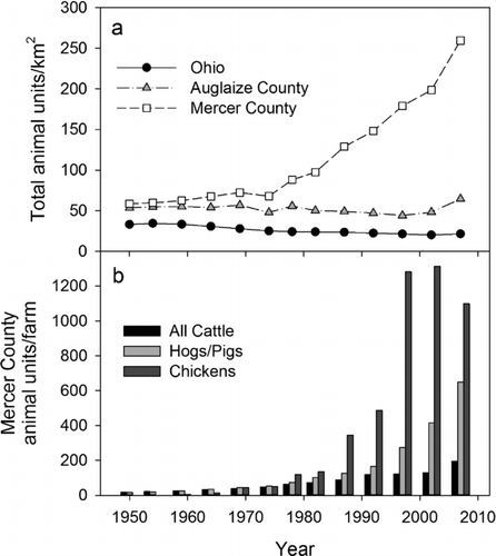
Table 3 Historical nutrient concentrations and biological productivity data for Grand Lake St. Marys. Individual measurements, ranges, or mean (range) are reported. ND = no data.
Table 4 Comparison of monthly external water and total phosphorus (TP) loads into Grand Lake during 2009–2011.
Figure 4 Panels (a) and (b) show seasonal and interannual variation in 2009–2011 Chickasaw Creek discharge and phosphorus concentrations, respectively. Panel (c) shows comparisons between monthly external TP loads (bars) for the entire Grand Lake watershed and in-reservoir total phosphorus (TP, solid lines), total reactive phosphorus (TRP dotted lines), and/or soluble reactive phosphorus (SRP dashed) masses. The vertical lines (panel c, right) show the start and finish of the alum treatment during 2011. Chickasaw Creek discharge measurements were performed by USGS, whereas nutrients were measured by the National Center for Water Quality Research (NCWQR). In-reservoir P measurements were performed on water samples collected near the south hatchery water intake (green), from the Ohio Department of Natural Resources, Division of Wildlife (DOW) boat ramp at the western end of the reservoir (blue), and from Ohio EPA (OEPA) sites (L-1, L-2, and L-3, averaged; red). Note that the scale for in-reservoir TP in tonnes is different for 2009 because of higher P concentrations measured in that year.
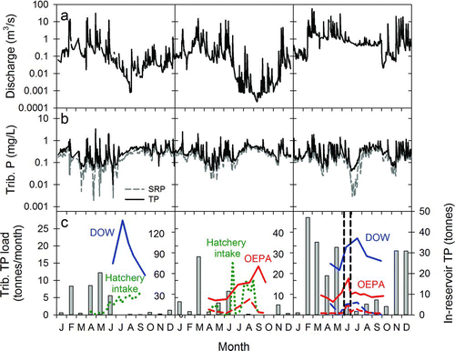
Figure 5 Comparisons of 2009 (a, b) total reactive phosphate (TRP), (c, d) ammonium; and (e, f) nitrate concentrations among 0.4 ha ponds that that were twice refilled with water from Grand Lake (GL), a 2.8 ha pond, or were isolated at the St. Marys SFH. Vertical dashed lines show when the 0.4 ha ponds were partially drained and refilled with their assigned source water. Error bars are omitted from pond measurements to improve clarity. Note that the scales for nitrate concentrations differ between panels (e) and (f).
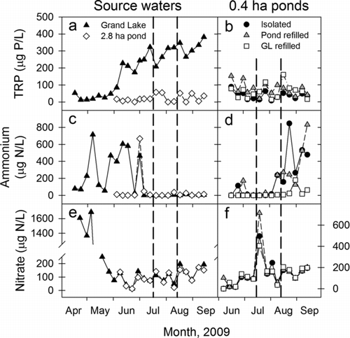
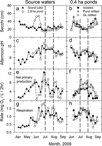
Figure 6 Comparisons of 2009 (a, b) Secchi transparency depth; (c, d) afternoon pH; (e, f) net phytoplankton primary productivity; and (g, h) respiration for source waters and among 0.4 ha ponds that were twice refilled with water from Grand Lake (GL), a 2.8 ha pond, or were isolated at the St. Marys SFH. Vertical dashed lines show when the 0.4 ha ponds were partially drained and refilled with their assigned source water. Error bars are omitted from pond measurements to improve clarity.