Figures & data
![Figure 1 EMAP Northeastern Lake Survey 1992–1994 sample lakes. In the text we refer to the combination of Omernik's (1987) N.E. Highlands and Adirondacks ecoregions as the NE Highlands.](/cms/asset/ba2c3cbc-8e3c-4986-9163-6cf97f5fe959/ulrm_a_877544_f0001_b.gif)
![Figure 2 Field sampling design with 10 near-shore stations at which data were collected to characterize near shore lake riparian and littoral physical habitat in the EMAP-Northeastern Lake Survey. The 10 stations were systematically spaced around the shore of the lake from a random starting point. Insert shows riparian plot, shoreline band, and littoral plot located at each station.](/cms/asset/1fd9bcf1-1b00-498c-813c-0b985d8807d9/ulrm_a_877544_f0002_oc.jpg)
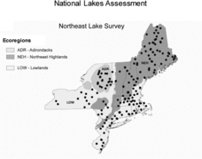
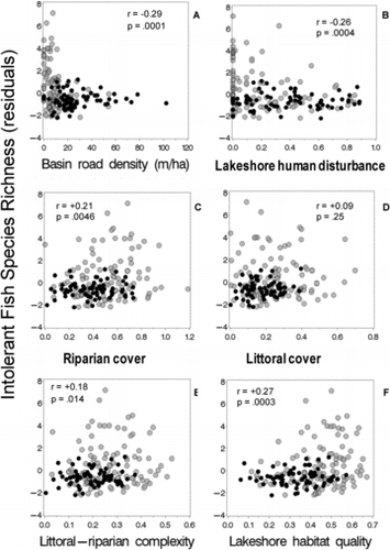
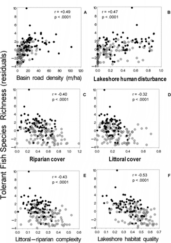
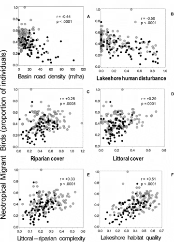
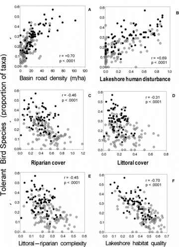
Table 1 Correlations of EMAP Northeast Lake Survey biotic metrics and habitat indices with catchment land use and geoclimatic variables. Spearman r with absolute values >0.30 have p < 0.0001 (Bonferroni-adjusted p < 0.0015); those between 0.25 and 0.30 have p < 0.001 (adjusted p < 0.15). Parentheses denote r values before watershed area correction. Data from US EPA's EMAP probability survey of 185 lakes during the spring (birds) and summer (fish and habitat) seasons of 1992–1994 (179 lakes with complete set of variables used here). Correlations >|0.40| are bold.
![Figure 3 Intolerant fish species richness vs. catchment road density and 5 physical habitat indices. Species richness expressed as residuals of the number of species regressed against log10 lake area. Grey dots = NE Highlands; black dots = NE Lowlands (Fig. 1).](/cms/asset/b822ba26-13c4-4978-8332-cb670f2093a5/ulrm_a_877544_f0003_b.gif)
![Figure 4 Tolerant fish species richness vs. catchment road density and 5 physical habitat indices. Species richness expressed as residuals of the number of species regressed against log10 lake area. Grey dots = NE Highlands; black dots = NE Lowlands (Fig. 1).](/cms/asset/0ea280b5-49c1-40d7-9cb9-b64ab9a10d8a/ulrm_a_877544_f0004_b.gif)