Figures & data
![Figure 1 Location of lakes >20 ha in Minnesota. Docks were counted on 150 highlighted lakes, 50 in each of 3 ECS provinces that contain numerous lakes.](/cms/asset/61c5abcb-39f3-4483-9c66-75b65b2c038a/ulrm_a_1053010_f0001_c.gif)
![Figure 2 A section of shoreline showing the automated-counted dock polygons and points along with Minnesota Land Use and Cover (MNLU) developed raster cells. The 2 circles represent a 30 m and 75 m search radius around the black shoreline point in their center. This point would be classified as developed according to both the automated-counted dock data (dock within 30 m) and the MNLU data (developed cell center point within 75 m). The background shows the 2008 National Agricultural Imagery Program (NAIP) aerial photo.](/cms/asset/8e54fcbb-0497-4b03-9149-9a6c9e9a6448/ulrm_a_1053010_f0002_c.gif)
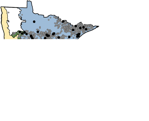
Table 1 Measures of classification accuracy derived from confusion or error matrices, composed of the count data in the first 4 rows (Metz Citation1978, Fielding and Bell 1997).
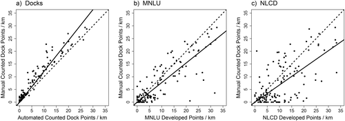
Table 2 Selected characteristics for 150 Minnesota lakes as a whole and separated by ecoregion: Laurentian mixed forest (Forest); eastern broadleaf forest (Transition) and prairie parkland (Prairie). Developed shore points/km uses generated points along the shoreline classified by calculating their proximity to the nearest development indicator for each dataset: manual-counted docks, automated-counted docks, Minnesota Land Use and Cover (MNLU), National Land Cover Database (NLCD), and a composite dataset containing developed cells from each of the 2 raster datasets (Combined).
![Figure 3 Total operating characteristic (TOC) curves using statewide data from a semiautomated image analysis of docks (Docks), Minnesota Land Use and Cover (MNLU), National Land Cover Database (NLCD), and Combined MNLU and NLCD datasets. The total number of hits+misses is shown by the horizontal line at the top of the plot; the gray diagonal line shows the expected curve for a random relationship; and the gray triangles are mathematically impossible areas for the TOC curve. The vertical line shows the point where the number of points classified as developed equals the actual number of developed points. Solid dots on each curve mark the 75 m cutoff point, and the open square marks the 30 m cutoff point for Docks.](/cms/asset/b9c67443-d261-4d8e-b7fd-691ac811e583/ulrm_a_1053010_f0003_b.gif)
![Figure 4 Total operating characteristic (TOC) curves using statewide data from a semiautomated image analysis of docks (Docks), Minnesota Land Use and Cover (MNLU), National Land Cover Database (NLCD), plotted separately by ecoregion: (a) Laurentian mixed forest (Forest); (b) Eastern broadleaf forest (Transition); and (c) Prairie parkland (Prairie). In each plot, the number of hits+misses is shown by the horizontal line at the top of the plot; the gray diagonal line shows the expected curve for a random relationship; and the gray triangles are mathematically impossible areas for the TOC curve. The vertical line shows the point where the number of points classified as developed equals the actual number of developed points. Solid dots on each curve mark the 75 m cutoff point, and the open square marks the 30 m cutoff point for Docks.](/cms/asset/07ae30fc-1a58-4509-8d4d-05920c21eea9/ulrm_a_1053010_f0004_b.gif)
![Figure 5 Scatter plots of developed shoreline point density for 150 lakes, classified using (a) automated-counted dock data (Docks); (b) Minnesota Land Use and Cover data (MNLU); and (c) National Land Cover Database (NLCD); and. The dashed lines show a 1:1 relationship, and the solid lines are linear regression lines.](/cms/asset/7ddd3eb5-ca6e-4a11-ae9e-dcedaa212ce9/ulrm_a_1053010_f0005_b.gif)