Figures & data
Table 1. Categorization of landfill study sites for methane emissions
Figure 1. Optical remote sensing study locations across the United States. The sites spanned climate types ranging from semiarid in the western USA to humid subtropical in the southern USA.
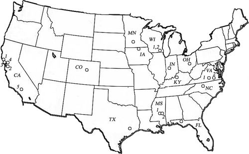
Figure 2. Schematic of the OTM-10 setup with an expected ACF from a perpendicular wind to the VRPM plane. Percentages represent the simulated methane surface emissions recovery with distance (11).
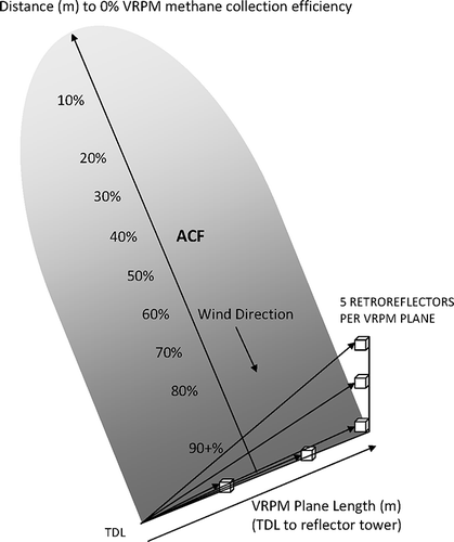
Figure 3. VRPM measurement layout for most study sites. Each side of the box is referred to as a “leg.” Multiplane setup allows efficient collection of data.
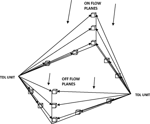
Figure 4. Example of a VRPM concentration gradient map. The x-axis represents the cross wind distance (TDL to tower in meters). Note that the concentration decreases with height. TDL located on lower left.
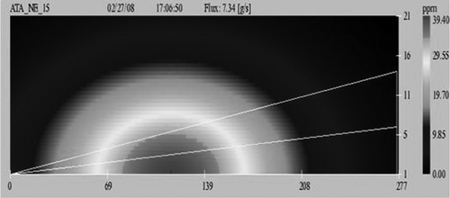
Figure 5. Comparison of the flux calculated from MLRM flat surface equation ACF to the flux calculated from the MLRM flat surface followed by a sloped surface equation ACF for all daily VRPM plane results.
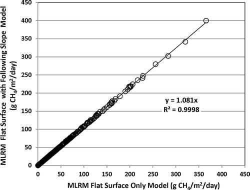
Figure 6. Comparison of the flux calculated by the MLRM flat surface model ACF to the flux calculated by the PSCM flat surface model ACF for daily VRPM plane results.
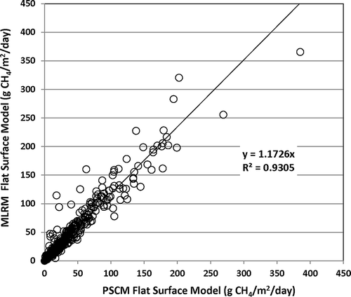
Table 2. Binned flux (g CH4/m2/day) results by campaign and cover types of working face, temporary soil, intermediate soil, final soil, and final synthetic
Figure 7. Comparison of daily VRPM plane daily leg averages to daily binned scan averages for the MLRM flat surface model calculation as g CH4/m2/day flux.
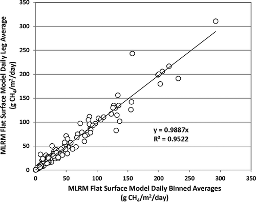
Figure 8. Comparison of campaign VRPM leg averages to campaign (3–5 days) binned averages using the MLRM flat surface model equation to calculate ACF to determine g CH4/m2/day flux.
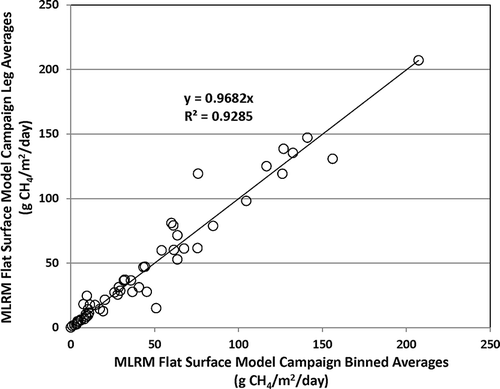
Figure 9. Working face flux results for three climate types based upon the MLRM flat equation to calculate ACF for binned campaign averages.
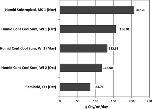
Figure 10. Temporary soil cover flux results for three climate types based upon the MLRM flat equation to calculate ACF for binned campaign averages.
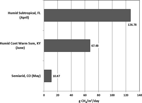
Figure 11. Intermediate soil cover flux results for five climate types based upon the MLRM flat equation to calculate ACF for binned campaign averages.
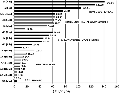
Figure 12. Final soil cover flux results for five climate types based upon the MLRM flat equation to calculate ACF for binned campaign averages. The NC location is a synthetically covered closed site with gas collection.
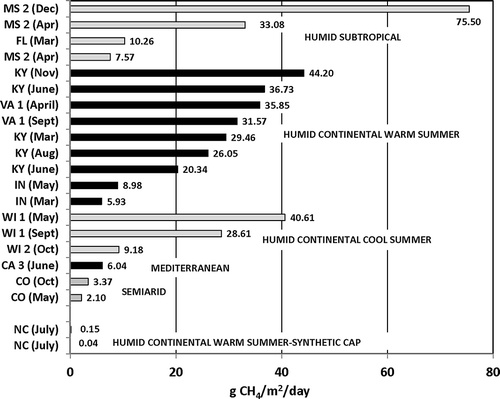
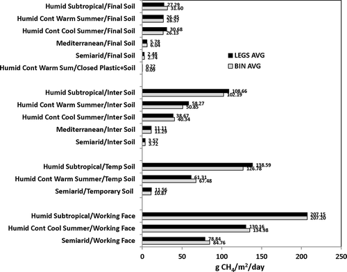
Figure 13. Comparison of all campaign leg flux averages and all campaign binned flux averages for all climate types.