Figures & data
Figure 1. (a) Spatial distribution of 30-yr average visibility in China (Sichuan and Chongqing are the regions within the gray lines). (b) Location and elevation of the Sichuan Basin, Chengdu and Chongqing (color figure available online).
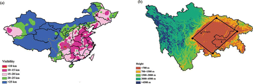
Table 1. Air quality category and the upper limit of daily average concentrations for each pollutant corresponding to different API classifications
Table 2a. Summary of visibility, meteorological factors, API, and PM10 pollution in Chengdu
Figure 2. Cumulative distribution functions of visibility in Chengdu and Chongqing.
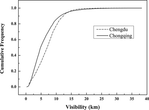
Figure 3. Percentage occurrence of days with PM10 as the primary pollutant and trends of PM10 concentrations in Chengdu and Chongqing.
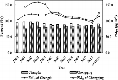
Figure 4. Monthly variations of visibility, PM10, and meteorological factors in Chengdu (a, b) and Chongqing (c, d).
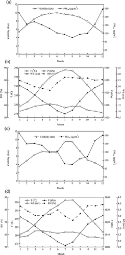
Figure 5. Trends of the 50th cumulative percentile of visibility and ridit values in (a) Chengdu and (b) Chongqing.
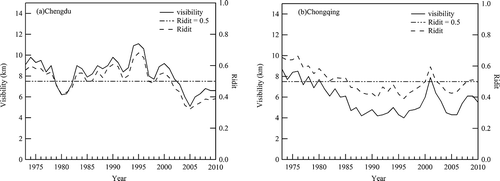
Figure 6. Days with visibility >19 km per year and days with visibility <10 km per year in Chengdu and Chongqing.
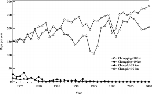
Figure 7. (a) Comparison of visibility between 1960s and 2000s in Chengdu and Chongqing. (b) Comparison of haze days between 1960s and 2000s in Chengdu and Chongqing.
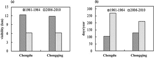
Figure 8. Trends in GDP and growth of vehicle ownership in Chengdu and Chongqing.
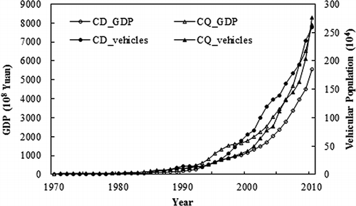
Table 2b. Summary of visibility, meteorological factors, API, and PM10 pollution in Chongqing
Figure 9. Scatter plots of visibility vs (a) RH and (b) wind speed in Chongqing (color figure available online).
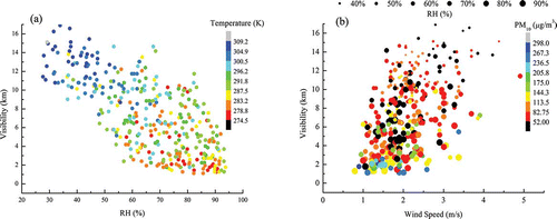
Figure 10. Scatter plots of visibility vs (a) RH and (b) wind speed in Chengdu (color figure available online).
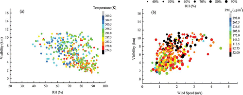
Table 3a. Correlation matrix of visibility (V), temperature (T), wind speed (WS), relative humidity (RH), pressure (P), PM10, and API (2000–2010) in Chengdu
Table 3b. Correlation matrix of visibility (V), temperature (T), wind speed (WS), relative humidity (RH), pressure (P), PM10, and API (2000–2010) in Chongqing
Table 4a. Factor loadings for visibility, meteorological factors, and PM10 pollutants in Chengdu
Table 4b. Factor loadings for visibility, meteorological factors, and PM10 pollutants in Chongqing
Table 5. Empirical models of visibility in Chengdu and Chongqing
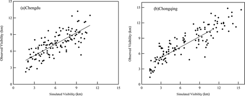
Figure 11. Scatter plots of simulated and observed daily average visibility in (a) Chengdu and (b) Chongqing during January, April, July, and October of 2011.