
Figures & data
Table 1. Model setup or WRF and CMAQ
Figure 1. Model domains with NO2 emissions for D1 (80 km), D2 (40 km), and D3 (20 km).
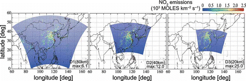
Figure 2. Monthly averaged spatial distributions of NO2 VCDs (units: e16 molecules cm-2) on a 1° × 1° grid based on satellite retrievals including (a) GOME-2, (b) SCIAMACHY, and (c) OMI, and (d)–(f) CMAQ simulations using D1 (80 km) for three different local times (09:30, 10:00, and 13:40–13:50) in June 2007. Absolute biases, calculated as (CMAQ-simulated NO2 VCDs) – (satellite NO2 VCDs), are shown in (g)–(i).
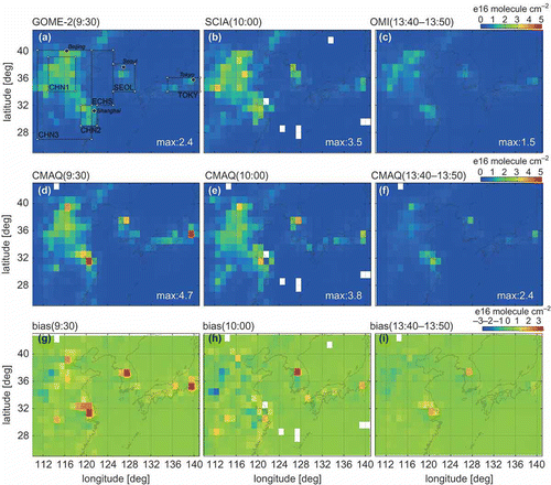
Figure 3. Monthly averaged spatial distributions of NO2 VCDs (units: e16 molecules cm-2) on a 1° × 1° grid based on satellite retrievals including (a) GOME-2, (b) SCIAMACHY, and (c) OMI, and (d)–(f) CMAQ simulations using D1 (80 km) for three different local times (09:30, 10:00, and 13:40–13:50) in December 2007. Absolute biases, calculated as (CMAQ-simulated NO2 VCDs) – (satellite NO2 VCDs), are shown in rows (g)–(i).
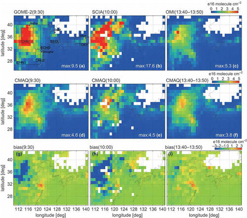
Table 2. Diagnostic areas
Figure 4. Scatterplots between monthly averaged NO2 VCDs of satellite retrievals (GOME-2 in the first row, SCIAMACHY in the second row, and OMI in the third row) and CMAQ simulations at different horizontal resolutions: D1 (80 km) in the first column, D2 (40 km) in the second column, and D3 (20 km) in the third column. Simulations were conducted for six diagnostic areas: CHN1 (near Beijing), CHN2 (near Shanghai), CHN3 (central eastern China), SEOL (near Seoul), TOKY (near Tokyo), and ECHS (over the East China Sea); details of these areas for June 2007 are listed in . Error bars represent the maximum and minimum values of the daily data for the diagnostic areas.
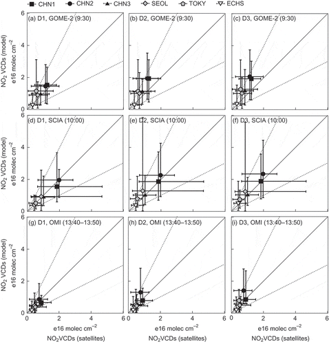
Figure 5. Scatterplots between monthly averaged NO2 VCDs of satellite retrievals (GOME-2 in the first row, SCIAMACHY in the second row, and OMI in the third row) and CMAQ simulations at different horizontal resolutions: D1 (80 km) in the first column, D2 (40 km) in the second column, and D3 (20 km) in the third column. Simulations were conducted for six diagnostic areas: CHN1 (near Beijing), CHN2 (near Shanghai), CHN3 (central eastern China), SEOL (near Seoul), TOKY (near Tokyo), and ECHS (over the East China Sea); details of these areas for December 2007 are listed in . Error bars represent the maximum and minimum values of the daily data for the diagnostic areas.
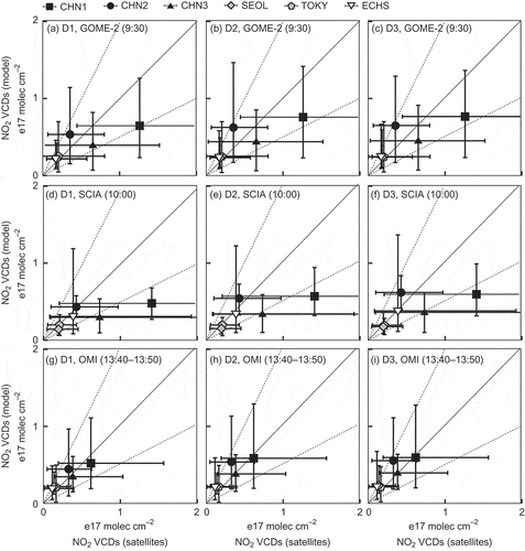
Table 3. Increases in CMAQ simurated NO2 VCDs due to model spatial resolution change (e16 molecules cm–2)