Figures & data
Figure 1. The major oil-and-gas-producing regions of Colorado and the locations of meteorological stations used for dispersion and exposure assessment. Interstate highways are also indicated.
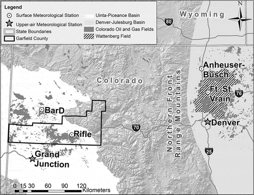
Figure 2. Emission rates utilized in this assessment. The values shown are the superset of rates from all sites and operations, and they are 1-hour-average rates derived from the 3-minute-average rates from CSU (Citation2016a, Citation2016b; Hecobian et al. Citation2019). The bottom and top of the boxes are the 25th and 75th percentiles, respectively; the line inside the box represents the median; the bottom and top whiskers are the 5th and 95th percentiles, respectively; and the asterisks are outliers beyond the 5th and 95th percentiles.
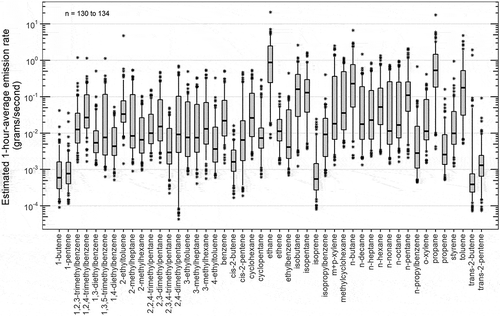
Figure 3. Monte Carlo simulation logic for estimating the concentration distribution of volatile organic compounds (VOCs) emitted by oil-and-gas well-development activities.
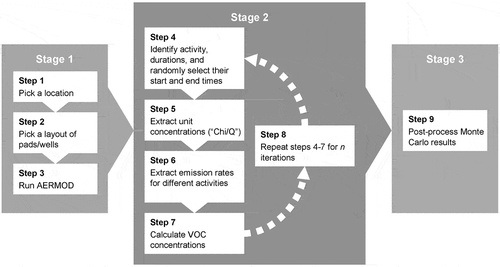
Figure 4. Flow diagram illustrating the steps in exposure assessment. Notes: O&G = oil and gas; VOC = volatile organic compound; AERMOD = American Meteorological Society/U.S. Environmental Protection Agency Regulatory Model; APEX = U.S. Environmental Protection Agency Air Pollutants Exposure Model; max = maximum.
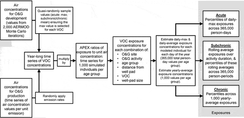
Table 1. Selected non-cancer criteria values (ppb).
Table 2. Overview of the largest acute non-cancer hazard quotients for the highest exposed hypothetical individuals at 500 and 2,000 feet from the well-pad centre.
Figure 5. Distributions of daily-maximum acute non-cancer hazard quotients for benzene (across the hypothetical population) at distances from the centre of the 1-acre well pad during flowback activities. The bottom and top of the boxes are the 25th and 75th percentiles, respectively; the line inside the box represents the median; and the bottom and top whiskers are the minima and maxima. Notes: log10 = logarithm base 10; NFR = Northern Front Range; GC = Garfield County; GC Ridge Top refers to the BarD site; GC Valley refers to the Rifle site.
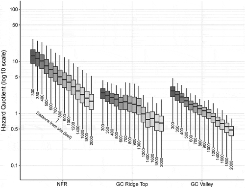
Figure 6. Distributions of subchronic non-cancer hazard indices for the neurotoxicity critical-effect group (across the hypothetical population) at distances from the centre of the 1-acre well pad during fracking activities. The bottom and top of the boxes are the 25th and 75th percentiles, respectively; the line inside the box represents the median; and the bottom and top whiskers are the minima and maxima. Notes: log10 = logarithm base 10; NFR = Northern Front Range; GC = Garfield County; GC Ridge Top refers to the BarD site; GC Valley refers to the Rifle site.
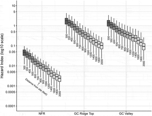
Figure 7. Distributions of chronic non-cancer hazard indices for the hematological critical-effect group (across the hypothetical population) at distances from the centre of the 1-acre well pad during production activities. The bottom and top of the boxes are the 25th and 75th percentiles, respectively; the line inside the box represents the median; and the bottom and top whiskers are the minima and maxima. Notes: log10 = logarithm base 10; NFR = Northern Front Range; GC = Garfield County; GC ridge top refers to the BarD site; GC Valley refers to the Rifle site.
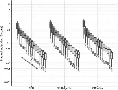
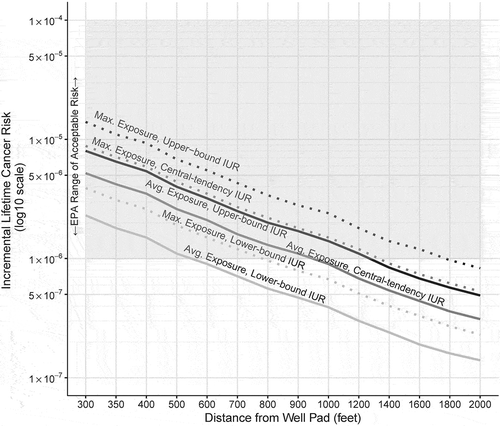
Figure 8. Incremental lifetime cancer risks from benzene exposure for average- and maximum-exposed hypothetical individuals at distances from the centre of the well pad during all activities in sequence at the Garfield County ridge-top site (1-acre development pad, 1-acre production pad). X-axis is not to scale. Grey box indicates the U.S. Environmental Protection Agency’s range of acceptable cancer risk. Notes: Avg. = average; max. = maximum; IUR = inhalation unit risk.