Figures & data
Figure 1. A–C, map of Faro Lake in North–East Sicily at different magnifications (arrows); D, sampling sites in 2013 as tentative replicas of the 1957–63 sampling plan (black dots). Sampling sites: 3 and 7 along the rocky coast near the entrance of the Margi Canal joining the Lake to the Ganzirri Lake; 8 at the entrance of the Eastern canal joining the Lake to the Messina Strait‐Ionian Sea; 9 at the entrance of the Northern canal joining the Lake to the Tyrrhenian Sea. Additional stations scattered in shallow water (0.1–3 m) of the Lake are indicated by 1, 2, 4, 5, 6, and 10. Isobathic spacing = 3 m.
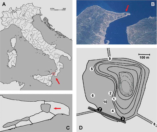
Table I. List of Porifera species (in alphabetical order) recorded in the Faro Lake over 50 years. Alien species and Mediterranean endemics are indicated by A and by asterisks (*), respectively.
Figure 2. Faro Lake. Sampling sites in the original illustration of 1957–63 (modified from Labate and Arena Citation1964). The 10 species evidenced by symbols are here interpreted as the most abundant/conspicuous in comparison with the lists reported in –. The indication of 19 spp. is not reported or better explained in the original paper. We report these historical data as indications without any concrete abundance validity. Isobathic spacing = 3 m.
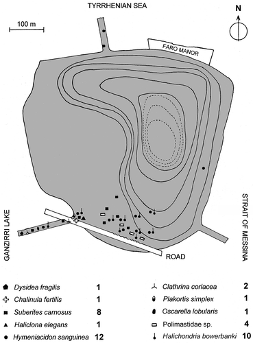
Table II. Geographic range of the species of Porifera recorded in the Faro Lake during the last 50 years.
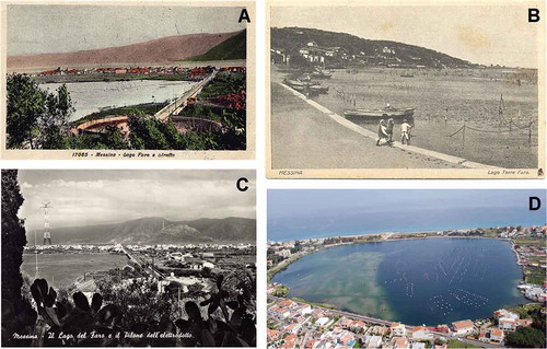
Figure 3. Faro Lake landscape through time. A, view from West to East, with the Calabria coast in the background (ca. 1900); B, ground view from the Southern road, with the Western coast in the background (ca. 1850); C, the same view of A after 50 years (ca. 1950); D, aerial view (northwards) of the Faro Lake (present day). The long term shellfish farming is evident in all images. Human settlement was not negligible over 150 years. See also Figure 2 for orientation.