Figures & data
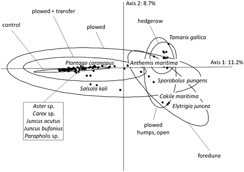
Figure 1. View of the Jaï dunes and of the site to be restored. (A) Side view of the beach and dunes. (B) View from the path looking toward Berre Lagoon.
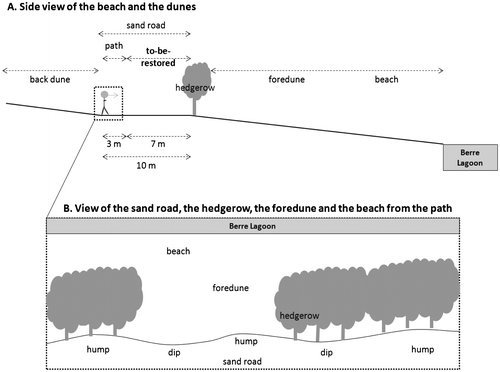
Table 1. List of the sites that were evaluated as candidate reference ecosystems.
Figure 2. Sampling design on the four candidate reference ecosystem sites (see Table ) and on the Jaï site.
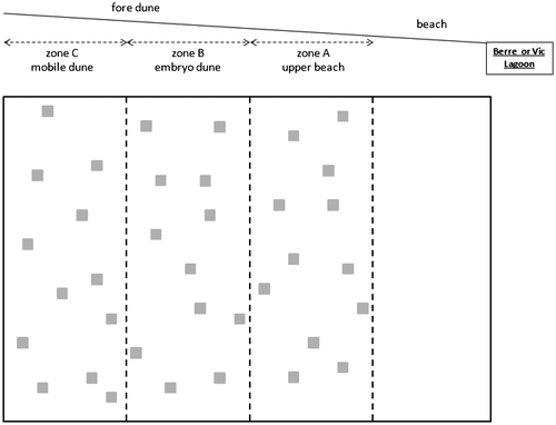
Figure 3. Aerial view of the Jaï site: the 1000-m long sand road was divided into 20 restoration sections of approximately 50-m average length where restoration treatments were applied (see Table
Table 2. Restoration treatments applied to the sand road.
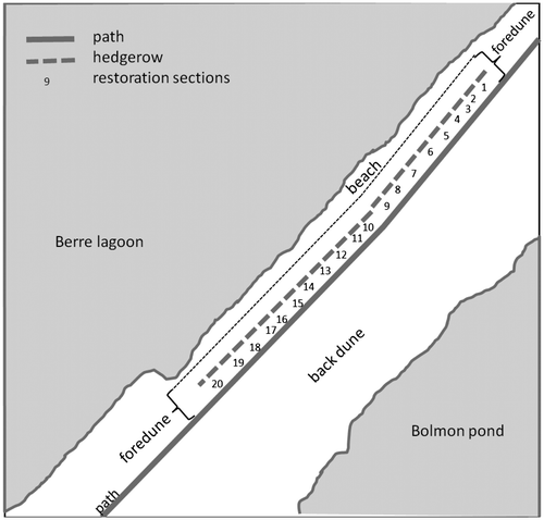
Table 2. Restoration treatments applied to the sand road.
Figure 4. Correspondence analysis performed on species per cent cover for the five sites [the four (see Table ) candidate reference ecosystems + the Jaï site] on the three zones (A, B and C; Figure ) (175 quadrats × 44 species). Only the most correlated species are shown. Samples are grouped according to site (name of the lagoon on which the site is found – Vic or Berre, name of the site). Zones are indicated only for the two sites on the Vic Lagoon (Airolles and Aresquiers) because zones overlapped on the other sites.
![Figure 4. Correspondence analysis performed on species per cent cover for the five sites [the four (see Table 1) candidate reference ecosystems + the Jaï site] on the three zones (A, B and C; Figure 2) (175 quadrats × 44 species). Only the most correlated species are shown. Samples are grouped according to site (name of the lagoon on which the site is found – Vic or Berre, name of the site). Zones are indicated only for the two sites on the Vic Lagoon (Airolles and Aresquiers) because zones overlapped on the other sites.](/cms/asset/2b736d0d-b687-436d-a949-58d0d7c9010d/tabg_a_919875_f0004_b.gif)
Figure 5. Mean number of species and of seeds in the seed bank on the Jaï site on the foredune, on the hedgerow and on the sand road: depth between 0 and 5 cm, light grey bars; between 5 and 15 cm, dark grey bars; deeper than 15 cm, black bars. Kruskal–Wallis test for species richness: χ² = 47.7, p < 0.001; Kruskal–Wallis test for seed density: χ² = 47.7, p < 0.001; the boldface letters indicate significant differences between areas, results of the Mann–Whitney post-hoc tests with Bonferroni p-adjustment.
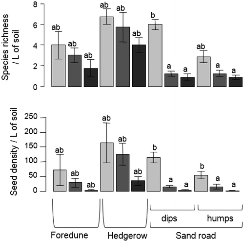
Figure 6. Correspondence analysis performed on species per cent cover for restoration-treated areas (see Table , sand road humps and dips, either adjacent to unbroken hedgerow or to hedgerow gaps) (136 quadrats × 39 species). Only the most correlated species are shown. Samples are grouped according to restoration treatment.