
Figures & data

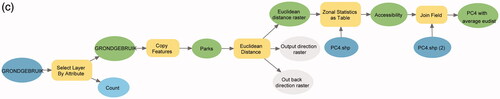
Figure 4. Annotating GIS operations with concepts. (a) Annotate Euclidean distance operation with input object and output field. (b) Annotate Zonal statistic operation with input object, field, and output content amount.
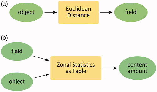
Figure 5. Mapping question components to input and output of GIS operations.
Figure 6. An abstract workflow formed by concepts.
Figure 7. A DAG of concept transformations in . Each vertex represents a concept of the data, and each directed edge refers to an abstract GIS operation (concrete tools can be found in ). Concept transformation models abstract information transformations in questions and GIS workflows, and thus are different from GIS workflows.
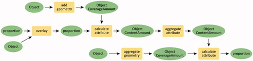
Table 1. Mapping abstract GIS operations in Figure 7 to GIS tools.
Figure 8. Methodology of developing a grammar for interpreting geo-analytical questions as concept transformations.
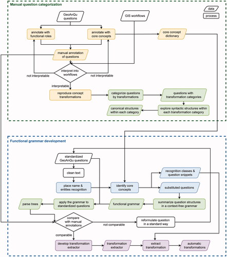
Figure 9. Named entity recognition in a geo-analytical question. The place name is captured by the Elmo-based NER model from AllenNLP. Entities, such as time, quantity, and date are recognized by the SpaCy Python package. Concepts, such as object, network are recognized by a pre-defined concept dictionary.
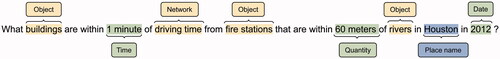
Table 2. Recognition results of the question ‘What buildings are within 1 minute of driving time from fire stations that are within 60 meters of rivers in Houston in 2010?’.
Figure 10. The parse tree of the question ‘What buildings are within 1 minute of driving time from fire stations that are within 60 meters of rivers in Houston in 2010?’.
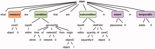
Table 3. Extraction results of the question ‘What buildings are within 1 minute of driving time from fire stations that are within 60 meters of rivers in Houston in 2010?’.
Table 4. Question categories in GeoAnQu with concept transformation models.
Figure 11. ER diagram of the functional roles, representing the constrained relationship among functional roles. For example, each measure can be constrained by ‘zero, one, or many’ measureConditions, while each measureCondition can constrain ‘only one’ measure.
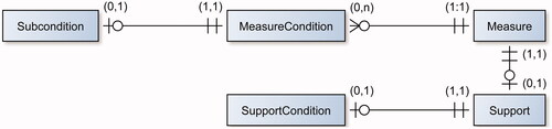
Figure 12. Transformations of the question ‘What buildings are within 1 minute of driving time from fire stations that are within 60 meters of rivers in Houston in 2010?’.
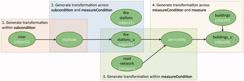
Figure 13. Frequency of questions for concept transformation models in GeoAnQu. Models are named according to output concepts in the leftmost column. The numbers (e.g. Network1, Network2) refer to different input concepts for a given output.
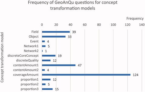
Table 5. Recall, precision and f1 score for 134 test geo-analytical questions.
Table 6. The number of correctly and falsely interpreted test questions with error sources.
Data and codes availability statement
The data and codes that support this study are available in ‘figshare.com’ with DOI https://doi.org/10.6084/m9.figshare.17009003.v7.