

ABSTRACT
This study employs an ideal free distribution (IFD) model to conduct a fine-grained analysis of environmental factors affecting the pre-Columbian colonisation sequence and settlement patterning in the southern Lesser Antilles of the Eastern Caribbean. We compiled a database of all known archaeological site locations and associated chronological data from St. Vincent, the Grenadines, and Grenada, and vetted this dataset for accuracy. We then performed multivariate statistical analysis of the vetted site data and 24 environmental variables hypothesised to influence settlement habitat quality, including soil attributes, proximity to freshwater/stream beds, structure and sizes of marine environments, and net primary productivity (NPP) layers. Iterative testing and refinement of the model allowed for the creation of a predictive map of pre-Columbian archaeological sites over time. Results indicate proximity to freshwater wetlands, NPP, and reef size were important variables influencing habitat choice. Additionally, latitude (distance from the equator) was also a significant variable, indicating support for a proposed colonisation of the southern Lesser Antilles that began in the northern Caribbean, rather than the south. Lastly, we provide a site inventory and map of predicted site locations that can aid in the management of threatened archaeological resources within the study region.
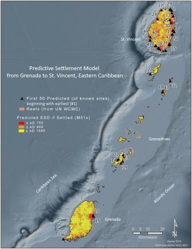
GRAPHICAL ABSTRACT
Acknowledgements
Many thanks to the guest editors, Elic Weitzel and Brian Codding, for arranging this special issue and inviting us to participate in the original SAA session. The authors also thank Ms. Dornet Hull of the St. Vincent Physical Planning Unit, Messrs. Michael Mason and Kenton Fletcher of the Grenada MOA GIS Office, and Mr. Michael Jessamy, Heritage Officer in Grenada’s Ministry of Tourism. We also thank two anonymous reviewers for comments on an earlier draft of this paper.
Disclosure Statement
No potential conflict of interest was reported by the authors.
Notes
1 Sometime in the early 16th century, the Spanish named Grenada after the recently conquered Andalusian city of ‘Granada’, and the Grenadines ‘Los Granadillos’ (little Granadas). These islands remained a political unit through French and British rule. In 1783 (inspired by the temporary French re-capture of Grenada in 1779), the British decided to annex most of the Grenadines to St. Vincent’s oversight (from Bequia to Union) (Martin Citation2013, 305). After independence in 1969, the country included them in its official name, St. Vincent and the Grenadines (SVG). However, for the purposes of this paper, we mostly treat the Grenadines and St. Vincent as separate entities.
2 It is worth noting that the logic of the IFD suggests the most suitable areas should be settled first and remain occupied until a change in suitability occurs, but permanent occupation is not a requirement — only that the same area continues to be occupied whenever the population returns, and/or that sites are not abandoned once their suitability matches the next ranked habitat (partly due to settlement costs and Allee effects). It remains debatable whether pre-Columbian settlements were permanently settled or periodically abandoned. While some archaeological sites contain deep and broad midden deposits suggestive of permanent settlement (e.g., Pearls and Sauteurs Bay in Grenada, or Sabazan and Grand Bay in Carriacou), others indicate more short-lived occupations (especially during the Troumassan period). Nonetheless, the IFD requires only some level of territorial affiliation that would deter new settlers from occupying someone else's village. The spacing of sites (declining over time) implies different individuals inhabited contemporaneous settlements. Given the size of the areas in our analysis (see the Supplemental Material for comparison between the buffers used and observed site clusters), there is also ample accommodation for occasional abandonment, reconstruction, and even settlement drift.
3 As is made clear in the Discussion, however, no proxy could duplicate the value of the soils data itself.
4 These targets were: Saladoid (AD 500 ± 250), Troumassan (AD 825 ± 75), and Suazan (1075 ± 200). Assigned ceramic phases were informed by radiocarbon dates, where available.
5 Specifically, the island outlines were converted to a raster with a 300 m cell-size; then the raster-to-point tool was used to place a point at the center of each cell. Note that computing power is the limiting factor for grid size — a 300 m grid created 8,792 points and took only a few minutes to compute the measurements (this was also the size used in the 2018 model); a 100 m cell size, on the other hand, would have created 79,055 points and required ∼60 h to process.
6 Randomized M51x: p = 0.490; adjusted R2 = 0.006; F-test = 0.941 (F-critical = 2.1).
7 Indeed, a Troumassan-period site, Mitchell, is <500 m away from Richmond (not unlike Grand Marquis or Beausejour). Bright (Citation2011, Apx I:25) mentions a local collection with both sites mixed together, supposedly exhibiting Saladoid through Suazan ceramics.
8 M51x overall: p = 0.007, adj. R2 = 0.262 (multiple R2 = 0.383), 146.9 on 41 DF, F-test = 3.176 (F-critical = 2.2).
Additional information
Notes on contributors
Jonathan A. Hanna
Jonathan A. Hanna is an Instructor in Anthropology at the Pennsylvania State University. His research interests include environmental anthropology, geoarchaeology, and human behavioural ecology in the Eastern Caribbean.
Christina M. Giovas
Christina M. Giovas is an Assistant Professor of Archaeology at Simon Fraser University. Her research focuses on prehistoric fisheries, animal translocations, and the human paleoecology of island and coastal settings, particularly the Caribbean and Oceania. She is Associate Editor for the Journal of Island and Coastal Archaeology and serves on the Board of the International Association for Caribbean Archaeology.