Figures & data
Figure 1. Map of the Caribbean. Insert: location of the island of Martinique in the Lesser Antillean island arc divided into the Leeward and Windward Islands (Figure copyright NEXUS1492).
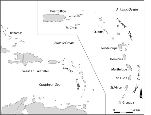
Figure 2. Topographic map of Anse Trabaud, with insert map of Martinique showing the locations of the site areas (Figure by Menno Hoogland).
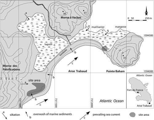
Figure 3. (a) Overview of the seaward shore of the current lagoon with – from left to right – muddy, organic lagoon sediment; loamy sediment resulting from mixing of marine sand and loam; marine sand from tombolo; (b) archaeological material eroding from the beach barrier at the lagoon side of Pointe Baham; (c) excavation of deeply buried archaeological deposits in the lagoon in Unit 17 (2015); and (d) pottery sherds and Aliger gigas shells on the bottom of the lagoon (Photos by Menno Hoogland).
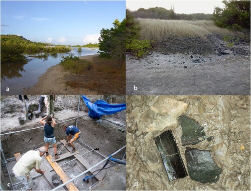
Figure 4. Paleogeomorphology of the site area. (a) Digital elevation model (DEM) constructed from elevation measurements obtained from the locations of excavation units using a Differential Global Positioning System (DGPS); (b) isopach map indicating the measured thickness of surficial loam deposits; and c. cross-section diagram showing the site’s stratigraphy along transect A (Figure by Julijan Vermeer).
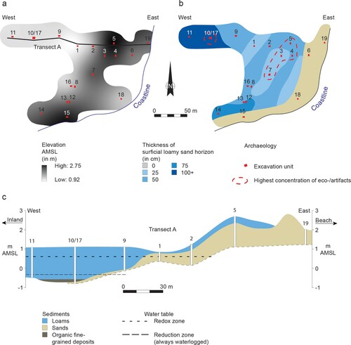
Figure 5. (a) Reconstruction of geomorphology of the site area showing the succession of beach ridges and the ancient extension of the lagoon; and (b) profile A-B showing the buried ancient lagoon and the infill of the depression enclosed by the eastern slope of Morne des Pétrification and a relict beach ridge (Figure by Menno Hoogland).
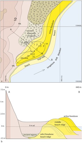
Figure 6. (a) Photograph and (b) schematic representation of stratigraphic sequence of the profile of unit 10 with channel shaped feature and lagoonal sediments; and (c). distribution of archaeological materials by weight. (Figure by Julijan Vermeer).
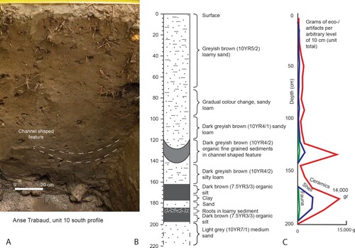
Figure 7. Multi-sample probability plot of the calibrated radiocarbon ages (1 σ = black, 2 σ = white) of Anse Trabaud.
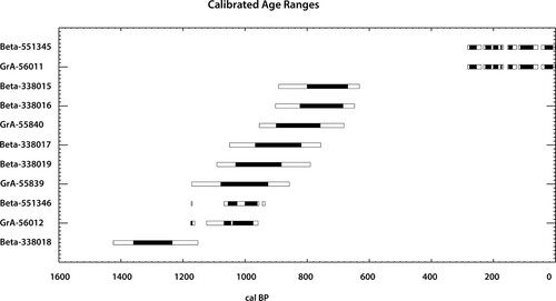
Table 1. Radiocarbon dates of Anse Trabaud and site-specific information (see for location). Radiocarbon ages were calibrated with CALIB 8.1.0 to obtain calibrated years BP (cal BP) (Stuiver, Reimer, and Reimer Citation2021). For the calibration of shell samples (Aliger gigas and Cittarium pica) a ΔR of – 158 ± 12 years (DiNapoli et al. Citation2021) has been applied. Calibration data sets are marine20 (Heaton et al. Citation2020) for shell samples and IntCal20 (Reimer et al. Citation2020) for plant remains. Beta = Beta Analytic, Miami, USA and GrA = Center for Isotope Research, University of Groningen, The Netherlands.
Figure 8. Troumassoid and Suazoid material culture. (a–c) Lithic flakes of red and yellow jasper; (d) flake of chalcedony; (e) coral tools (Porites porites); (f) axe blade made from St. Martin greenstone; (g) shell adze (Aliger gigas); (h) blackened pottery sherds from mangrove sediment; (i) Calivigny painted pottery vessel; and (j) Suazoid tri-legged cooking vessel (Sala et al. Citation2014; Photos and figure by Menno Hoogland).
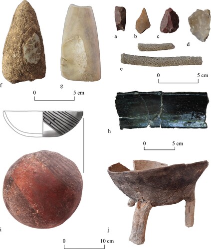
Table 2. Invertebrate remains identified, Anse Trabaud, Martinique.
Table 3. Invertebrate remains identified from unit 10/17 > 160 cm, Anse Trabaud, Martinique.
Table 4. Recovered ancient starch grains (identified taxa) by studied artefacts, and notes on other registered microscopic remains (foraminifera, diatoms, phytoliths), Anse Trabaud, Martinique.
Figure 9. Ancient starch grains recovered in Troumassoid tools. (a) Zea mays ATR-10, cooking pot; (b) Maranta sp. (ATR-16, cooking pot); (c) Manihot esculenta (ATR-15, cooking pot); (d) Capsicum sp. (ATR-15, cooking pot); (e) Xanthosoma cf. sagittifolium (ATR-10, cooking pot); (f) cluster of Zea mays (ATR-01, clay griddle); (g) cf. Phaseolus sp. (ATR-07, cooking pot); and (h) unidentified, twisted starch due to partially dry heat (ATR-11, serving bowl) (Photos by Jaime Pagán-Jiménez).
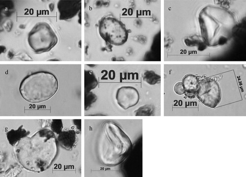
Figure 10. Benthic foraminifera, diatoms and phytoliths from the deeply buried deposits in the mangrove forest. (a,b) benthic foraminifera (ATR-01, clay griddle); (c,d) diatoms (ATR-16 [cooking pot] and ATR −26 [coral tool], respectively); (e,f) Arecaceae phytoliths, globular echinates (ATR-01 [clay griddle] and ATR-28 [stone tool], respectively); and g. grass buliform phytolith (ATR-26, coral tool) (Photos by Jaime Pagán Jiménez).
![Figure 10. Benthic foraminifera, diatoms and phytoliths from the deeply buried deposits in the mangrove forest. (a,b) benthic foraminifera (ATR-01, clay griddle); (c,d) diatoms (ATR-16 [cooking pot] and ATR −26 [coral tool], respectively); (e,f) Arecaceae phytoliths, globular echinates (ATR-01 [clay griddle] and ATR-28 [stone tool], respectively); and g. grass buliform phytolith (ATR-26, coral tool) (Photos by Jaime Pagán Jiménez).](/cms/asset/8b9599bc-42a5-49fd-88eb-121a0226a5fe/yenv_a_1921676_f0010_ob.jpg)
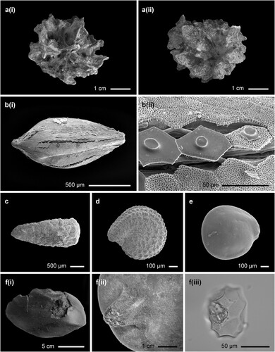
Figure 11. Plant remains from unit 10/17 at Anse Trabaud: a. (i) and a. (ii) – a decayed Hippomane macinella fruit; b. (i) a Cyperaceae seed and b. (ii) the epidermal cells close-up; c. a seed of Eclipta prostrata, d. – a seed of Portulaca oleracea, e. – a Chenopodiaceae seed, f. (i) the fruit that may belong to the Cucurbitaceae family the Squash family, f.(ii) – the stalk of the fruit (Photos by Michael Field), and f. (iii) – a phytolith extracted from the fruit (Photos by Jaime Pagán-Jiménez).