Figures & data
Figure 1. The distribution of Early and Middle Anglo-Saxon settlements and deserted Domesday vills in East Suffolk and their close spatial relationship with parish boundaries. It is proposed that this relationship the result of territorial division after settlement change. © Crown copyright and database rights 2023 Ordnance Survey (100025252). Drawn by author.
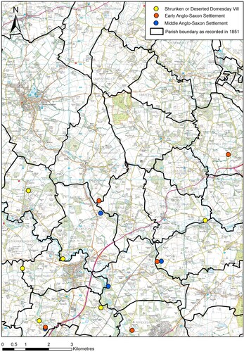
Figure 2. A case study of Marlesford and Parham in East Suffolk. An abandoned Early Saxon settlement lies near the boundary between the two parishes, approximately equidistant between the later occupation sites surrounding the parish churches. It is suggested that the Early Saxon settlement once had its own territory. When the settlement was abandoned, the territory of the failed site was equitably redistributed between nearby successful settlement sites to evenly share the burden of taxation with which it was associated (after Cox Citation2023). © Crown copyright and database rights 2023 Ordnance Survey (100025252). Drawn by author.
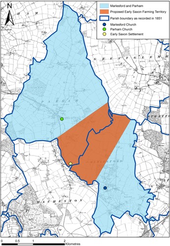
Figure 3. The hundredal pattern of Suffolk. © Crown copyright and database rights 2023 Ordnance Survey (100025252). Drawn by author using hundred boundary data from S. Brookes, Atlas of Early Medieval England, 2020. https://doi.org/10.5284/1058999.
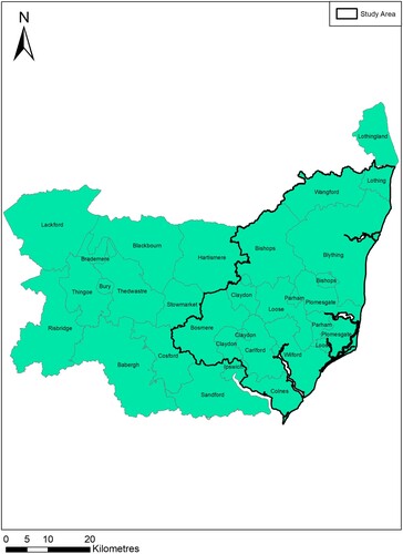
Figure 4. The distribution of Early Saxon settlements in the study area and their varying relationship with hundred boundaries. Left: Early Saxon settlements; Right: Middle Saxon. © Crown copyright and database rights 2023 Ordnance Survey (100025252). Drawn by author using hundred boundary data from S. Brookes, Atlas of Early Medieval England, 2020. https://doi.org/10.5284/1058999.
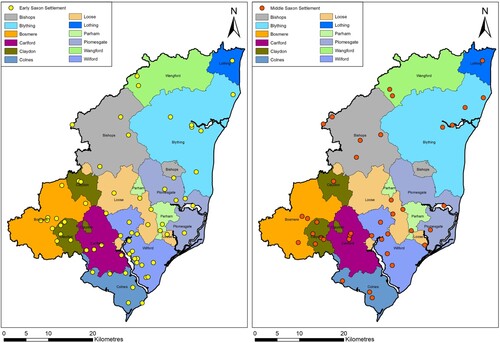
Figure 5. The distribution of Early and Middle Saxon settlements in the area surrounding Blything Hundred. It is clear that the boundary of the hundred was devoid of occupation. Drawn by author using hundred boundary data from S. Brookes, Atlas of Early Medieval England, 2020. https://doi.org/10.5284/1058999.
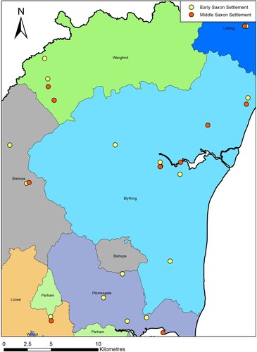
Figure 6. The hundredal pattern of East Suffolk and its relationship with topography. Few hundred boundaries do not extend into the fertile landscapes surrounding river valleys that were desirable for early settlement. © Crown copyright and database rights 2023 Ordnance Survey (100025252). Drawn by author using hundred boundary data from S. Brookes, Atlas of Early Medieval England, 2020. https://doi.org/10.5284/1058999.
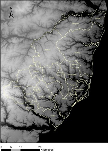
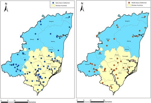
Figure 7. The distribution of settlements and their relationship with the boundary of the Wicklaw hundreds (a territorial unit comprising the hundreds of Carlford, Colneis, Loose, Plomesgate, Wilford and the half-hundred of Parham). Left, Early Saxon settlements, Right Middle Saxon. © Crown copyright and database rights 2023 Ordnance Survey (100025252). Drawn by author using hundred boundary data from S. Brookes, Atlas of Early Medieval England, 2020. https://doi.org/10.5284/1058999.