3,607
Views
63
CrossRef citations to date
0
Altmetric
Original Articles

After the Ice: Holocene Geomorphic Activity in the Scottish Highlands

Pages 8-52 | Published online: 12 Sep 2008

Figures & data

Figure 1 The Scottish Highlands, showing locations mentioned in the text

Figure 1 The Scottish Highlands, showing locations mentioned in the text

Figure 2 Simplified terrestrial paraglacial sediment cascade. Most primary sediment stores have experienced a transition from net accumulation to net erosion during the Holocene. Source: Adapted from Ballantyne (Citation2002a) with permission from Elsevier
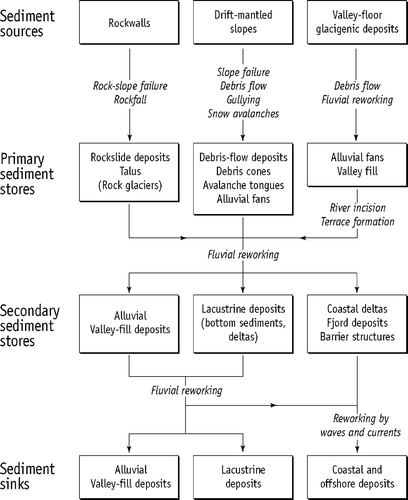
Figure 2 Simplified terrestrial paraglacial sediment cascade. Most primary sediment stores have experienced a transition from net accumulation to net erosion during the Holocene. Source: Adapted from Ballantyne (Citation2002a) with permission from Elsevier

Figure 3 Exhaustion model of paraglacial sediment release, in which rate of sediment release (λ) is related to the proportion of ‘available’ sediment remaining in the sediment source. In this example λ = 0.0005 yr−1 (i.e. 0.05% of remaining ‘available’ sediment is removed each year)
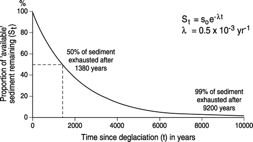
Figure 3 Exhaustion model of paraglacial sediment release, in which rate of sediment release (λ) is related to the proportion of ‘available’ sediment remaining in the sediment source. In this example λ = 0.0005 yr−1 (i.e. 0.05% of remaining ‘available’ sediment is removed each year)

Figure 4 Change in volume of stored sediment as a fraction of the volume of ‘available’ sediment in a paraglacial sediment source plotted against time elapsed since deglaciation for λ = 1.0 kyr−1 (0.001 yr−1) and a range of values of κ (see text). For κ > 0, storage inevitably reaches a peak then declines. The maximum volume of sediment held in storage and the timing of maximum storage depend on the relative values of λ and κ. Source: Adapted from Ballantyne (Citation2003a)
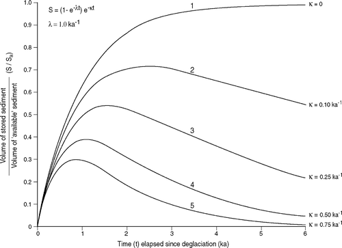
Figure 4 Change in volume of stored sediment as a fraction of the volume of ‘available’ sediment in a paraglacial sediment source plotted against time elapsed since deglaciation for λ = 1.0 kyr−1 (0.001 yr−1) and a range of values of κ (see text). For κ > 0, storage inevitably reaches a peak then declines. The maximum volume of sediment held in storage and the timing of maximum storage depend on the relative values of λ and κ. Source: Adapted from Ballantyne (Citation2003a)

Figure 5 Classification of large rock-slope failures in the Scottish Highlands. All categories depicted represent idealized end members of a continuum of failure types. Source: Adapted from Jarman (Citation2006), with permission from Elsevier
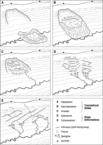
Figure 5 Classification of large rock-slope failures in the Scottish Highlands. All categories depicted represent idealized end members of a continuum of failure types. Source: Adapted from Jarman (Citation2006), with permission from Elsevier

Figure 6 Arrested translational rockslide in Glen Roy (Lochaber). The slide has disrupted and over-run shorelines formed at the margins of a lake that was dammed by glacier ice during the Loch Lomond Stade
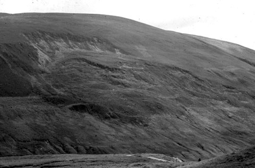
Figure 6 Arrested translational rockslide in Glen Roy (Lochaber). The slide has disrupted and over-run shorelines formed at the margins of a lake that was dammed by glacier ice during the Loch Lomond Stade

Figure 7 The Beinn Alligin rock avalanche, Torridon. Roughly nine million tonnes of rock failed along a 42° failure plane bounded by converging fault scarps and travelled 1.25 km down the floor of a corrie. Cosmogenic isotope dating of runout boulders places the date of failure at 4.0 ± 0.3 kyr, approximately 7500 years after deglaciation
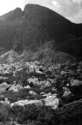
Figure 7 The Beinn Alligin rock avalanche, Torridon. Roughly nine million tonnes of rock failed along a 42° failure plane bounded by converging fault scarps and travelled 1.25 km down the floor of a corrie. Cosmogenic isotope dating of runout boulders places the date of failure at 4.0 ± 0.3 kyr, approximately 7500 years after deglaciation

Figure 8 The Coire Gabhail rock avalanche, Glen Coe. Failure of rhyolitic lavas about 1800 years ago resulted in the formation of a huge talus cone
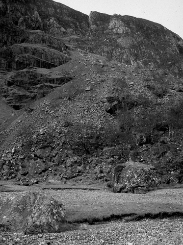
Figure 8 The Coire Gabhail rock avalanche, Glen Coe. Failure of rhyolitic lavas about 1800 years ago resulted in the formation of a huge talus cone

Figure 9 The Carn Ban rock-slope failure near Spittal of Glenshee. Initial sliding failure along bedding planes generated two massive debris flow lobes on either side of a bedrock protrusion
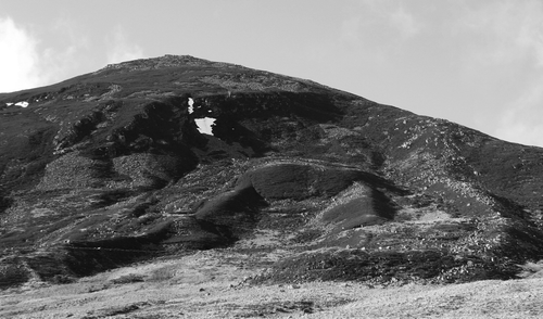
Figure 9 The Carn Ban rock-slope failure near Spittal of Glenshee. Initial sliding failure along bedding planes generated two massive debris flow lobes on either side of a bedrock protrusion

Figure 10 The Trotternish escarpment, northern Skye. The area of landslide east of the scarp (shaded) is the largest area of landslide terrain in Britain, but only the inner zone of angular landslide blocks represents failure since deglaciation, which in this area occurred about 17 000 years ago. Cosmogenic isotope dating of landslide pinnacles indicates that The Storr landslide occurred about 6500 years ago
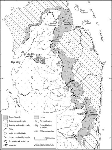
Figure 10 The Trotternish escarpment, northern Skye. The area of landslide east of the scarp (shaded) is the largest area of landslide terrain in Britain, but only the inner zone of angular landslide blocks represents failure since deglaciation, which in this area occurred about 17 000 years ago. Cosmogenic isotope dating of landslide pinnacles indicates that The Storr landslide occurred about 6500 years ago

Figure 11 The Beinn Fhada slope deformation in Kintail, which covers an area of about 3 km2 and supports slope bulges and antiscarps up to 800 m long and 10 m high. Source: Photograph by D. Jarman
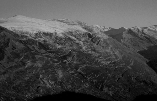
Figure 11 The Beinn Fhada slope deformation in Kintail, which covers an area of about 3 km2 and supports slope bulges and antiscarps up to 800 m long and 10 m high. Source: Photograph by D. Jarman

Figure 12 Distribution of rock-slope failures exceeding 0.25 km2 in area on the Scottish mainland, showing the clustering of large RSFs in some areas such as Kintail, Lochaber and Arrochar. Source: Adapted from Jarman (Citation2006), with permission from Elsevier
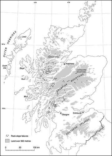
Figure 12 Distribution of rock-slope failures exceeding 0.25 km2 in area on the Scottish mainland, showing the clustering of large RSFs in some areas such as Kintail, Lochaber and Arrochar. Source: Adapted from Jarman (Citation2006), with permission from Elsevier

Figure 13 Relict talus accumulations at the foot of the Trotternish escarpment, northern Skye. Radiocarbon dating of buried soils exposed in gullies incised into the talus has allowed reconstruction of the history of talus accumulation and reworking by debris flows at this site. Most talus accumulation occurred in the Lateglacial and early Holocene
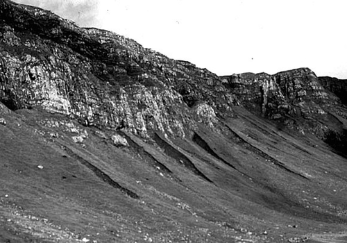
Figure 13 Relict talus accumulations at the foot of the Trotternish escarpment, northern Skye. Radiocarbon dating of buried soils exposed in gullies incised into the talus has allowed reconstruction of the history of talus accumulation and reworking by debris flows at this site. Most talus accumulation occurred in the Lateglacial and early Holocene

Figure 14 A hillslope debris flow in the Lairig Ghru, Cairngorm Mountains, photographed soon after a heavy rainstorm in 1978 released 71 debris flows into the valley
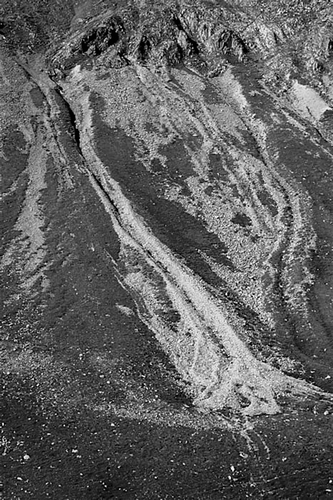
Figure 14 A hillslope debris flow in the Lairig Ghru, Cairngorm Mountains, photographed soon after a heavy rainstorm in 1978 released 71 debris flows into the valley

Figure 15 Debris flows and debris cones on the flanks of glacial troughs: Gleann Einich, Cairngorms (left) and Glen Docherty near Kinlochewe (right). Source: Adapted from a map in Curry (Citation1999a) and reproduced with the author's permission
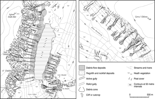
Figure 15 Debris flows and debris cones on the flanks of glacial troughs: Gleann Einich, Cairngorms (left) and Glen Docherty near Kinlochewe (right). Source: Adapted from a map in Curry (Citation1999a) and reproduced with the author's permission

Figure 16 Section cut in debris-flow deposits, Trotternish, northern Skye. The dark bands are buried organic soils, and the intervening and overlying beds are debris-flow deposits that buried the soils. Radiocarbon dating of the top and base of individual soil horizons allows the timing of debris flows to be reconstructed
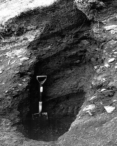
Figure 16 Section cut in debris-flow deposits, Trotternish, northern Skye. The dark bands are buried organic soils, and the intervening and overlying beds are debris-flow deposits that buried the soils. Radiocarbon dating of the top and base of individual soil horizons allows the timing of debris flows to be reconstructed

Figure 17 Calibrated radiocarbon ages relating to debris-flow units overlying or underlying buried soils or peat layers at nine sites, showing possible periods of enhanced activity. The horizontal bars encompass the 95% confidence limits for each calibrated age
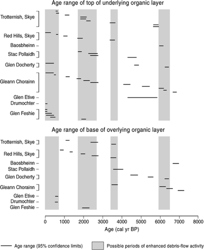
Figure 17 Calibrated radiocarbon ages relating to debris-flow units overlying or underlying buried soils or peat layers at nine sites, showing possible periods of enhanced activity. The horizontal bars encompass the 95% confidence limits for each calibrated age

Figure 18 Recent debris flows in the Lairig Ghru, Cairngorm Mountains, mapped from aerial photographs taken in 1961 and 1980 and showing extensive burial of an earlier (1956) generation of debris flow deposits by later (1978) flows. Source: Adapted from Luckman (Citation1992)
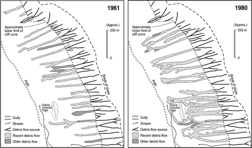
Figure 18 Recent debris flows in the Lairig Ghru, Cairngorm Mountains, mapped from aerial photographs taken in 1961 and 1980 and showing extensive burial of an earlier (1956) generation of debris flow deposits by later (1978) flows. Source: Adapted from Luckman (Citation1992)

Figure 19 Avalanche boulder tongues crossing the highest part of the Lairig Ghru and ascending a short distance up the opposite slope
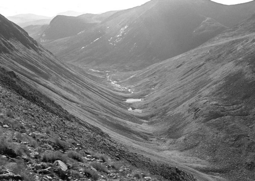
Figure 19 Avalanche boulder tongues crossing the highest part of the Lairig Ghru and ascending a short distance up the opposite slope

Figure 20 Relict Holocene alluvial fan in Glen Elchaig, Kintail. The parent stream has incised the upper fan, and most of the fan is now vegetation-covered and inactive
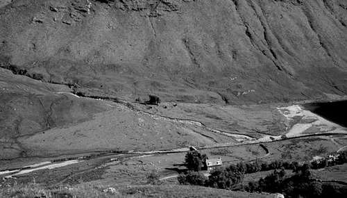
Figure 20 Relict Holocene alluvial fan in Glen Elchaig, Kintail. The parent stream has incised the upper fan, and most of the fan is now vegetation-covered and inactive

Figure 21 The River Cononish, Strath Fillan, a wandering gravel-bed river typical of many in the Highlands, with a meandering planform exhibiting localised braiding
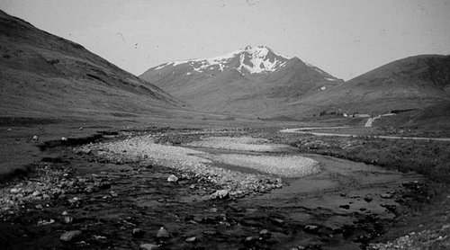
Figure 21 The River Cononish, Strath Fillan, a wandering gravel-bed river typical of many in the Highlands, with a meandering planform exhibiting localised braiding

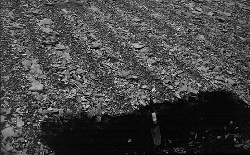
Figure 22 Section through the Main Holocene Terrace of the River Findhorn in upper Strathdearn. The spade is resting on the edge of the active river channel. The stratigraphy of the terrace at this site comprises 1.1 m of coarse bar deposits overlain by 0.3 m of sandy overbank deposits and 0.9 m of late Holocene peat. The terrace implies that the Holocene floodplain at this site was once 1.4 m higher than now, and has subsequently been incised by the river
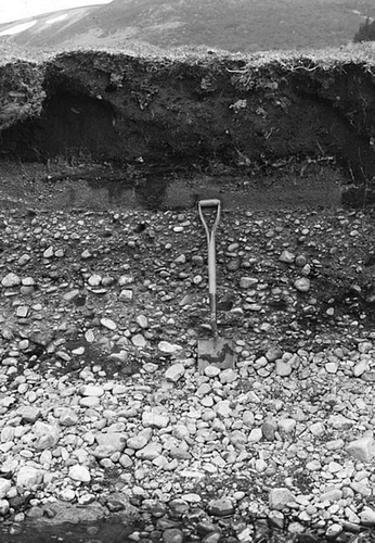
Figure 22 Section through the Main Holocene Terrace of the River Findhorn in upper Strathdearn. The spade is resting on the edge of the active river channel. The stratigraphy of the terrace at this site comprises 1.1 m of coarse bar deposits overlain by 0.3 m of sandy overbank deposits and 0.9 m of late Holocene peat. The terrace implies that the Holocene floodplain at this site was once 1.4 m higher than now, and has subsequently been incised by the river

Figure 23 The Edendon alluvial fan in the central Grampians. The front of the fan has been exposed through lateral migration of the trunk stream, revealing three buried peat horizons. The lowest peat marks the top of the Main Holocene Terrace. Radiocarbon dating of the buried peats has shown that the entire fan was deposited during just three flood events between 2.3 kyr and 0.8 kyr
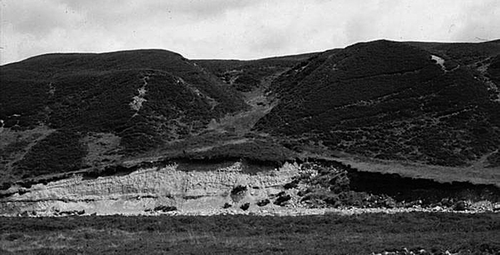
Figure 23 The Edendon alluvial fan in the central Grampians. The front of the fan has been exposed through lateral migration of the trunk stream, revealing three buried peat horizons. The lowest peat marks the top of the Main Holocene Terrace. Radiocarbon dating of the buried peats has shown that the entire fan was deposited during just three flood events between 2.3 kyr and 0.8 kyr

Figure 24 Coastal dunes at Luskentyre on the west coast of Harris, Outer Hebrides. At this site, removal of protective vegetation cover has resulted in renewed wind erosion of previously-stable dunes. Source: Reproduced with permission from Crawford (Citation2008)
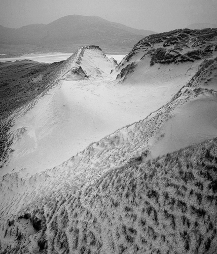
Figure 24 Coastal dunes at Luskentyre on the west coast of Harris, Outer Hebrides. At this site, removal of protective vegetation cover has resulted in renewed wind erosion of previously-stable dunes. Source: Reproduced with permission from Crawford (Citation2008)

Figure 25 Wind-abraded boulders (ventifacts) of Torridon Sandstone on the beach at Opinan, Wester Ross. Source: Photograph by Dr Peter Wilson
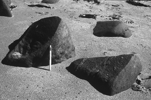
Figure 25 Wind-abraded boulders (ventifacts) of Torridon Sandstone on the beach at Opinan, Wester Ross. Source: Photograph by Dr Peter Wilson

Figure 26 Deflation surface at 800 m on the northern plateau of An Teallach, Wester Ross, showing the lag deposit of fine gravel amidst larger boulders. The light-coloured boulders are Cambrian quartzite erratics
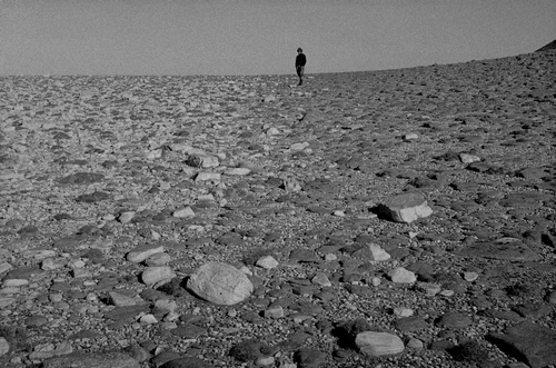
Figure 26 Deflation surface at 800 m on the northern plateau of An Teallach, Wester Ross, showing the lag deposit of fine gravel amidst larger boulders. The light-coloured boulders are Cambrian quartzite erratics

Figure 27 Eroded vegetation-covered sand sheets at the margin of the northern plateau of An Teallach, Wester Ross. The sand at the plateau margin reaches depths of up to 4 m
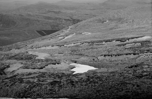
Figure 27 Eroded vegetation-covered sand sheets at the margin of the northern plateau of An Teallach, Wester Ross. The sand at the plateau margin reaches depths of up to 4 m

Figure 28 Rounding of bedrock by prolonged granular disaggregation (microgelifraction) at 960 m on An Teallach, Wester Ross. The foreground outcrop is of Torridon Sandstone; that in the background is of coarse-grained Cambrian Quartzite
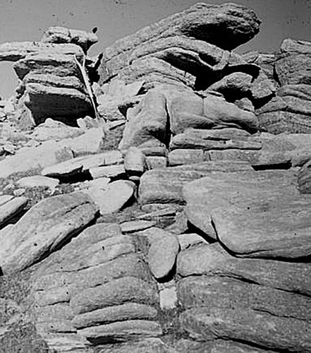
Figure 28 Rounding of bedrock by prolonged granular disaggregation (microgelifraction) at 960 m on An Teallach, Wester Ross. The foreground outcrop is of Torridon Sandstone; that in the background is of coarse-grained Cambrian Quartzite

Figure 29 Active sorted stripes on basalt, Trotternish escarpment, northern Skye

Figure 29 Active sorted stripes on basalt, Trotternish escarpment, northern Skye

Figure 30 Active solifluction sheets in the North-West Highlands. The steep fronts (risers) are characteristic of present activity
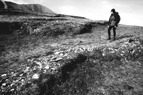
Figure 30 Active solifluction sheets in the North-West Highlands. The steep fronts (risers) are characteristic of present activity

Figure 31 Ploughing boulders on the Fannich Mountains, NW Scotland. These boulders have advanced downslope faster than the surrounding soil, leaving a furrow upslope
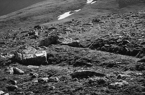
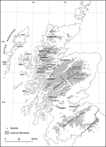
Figure 31 Ploughing boulders on the Fannich Mountains, NW Scotland. These boulders have advanced downslope faster than the surrounding soil, leaving a furrow upslope
Reprints and Corporate Permissions

Please note: Selecting permissions does not provide access to the full text of the article, please see our help page How do I view content?

To request a reprint or corporate permissions for this article, please click on the relevant link below:

Academic Permissions

Please note: Selecting permissions does not provide access to the full text of the article, please see our help page How do I view content?

Obtain permissions instantly via Rightslink by clicking on the button below:

If you are unable to obtain permissions via Rightslink, please complete and submit this Permissions form. For more information, please visit our Permissions help page.