
Figures & data
Figure 1. The hydrographic Great Basin. (A) Great Basin perimeter and subwatershed boundaries with six subregions (bold lines) used to assess extant American pika sites (black dots). More than one observation record is included in most dots at this scale. (B) Mountain ranges mentioned in the text where extant pika sites occur (not all ranges are shown). Codes for mountain ranges: Northwest subregion: GL, Glass Mountains; HM, Hart Mountains; HC, Hayes Canyon Range; HR, High Rock; MU, Madeline Uplands; MM, Mosquito Mountains; PP, Painted Point Range; SP, Sheldon Plateau; SM, Steens Mountains; WM, Warner Mountains. Southwest subregion: BM, Bodie Mountains; CR, Carson Range; GM, Glass Mountains; IC, Inyo Craters; MC, Mono Craters; NR, New Range; PN, Pine Nut Mountains; SN, Sierra Nevada; SW, Sweetwater Mountains; WA, Wassuk Mountains; WH, White Mountains; ZM, Zunnamed Mountains. North Central subregion: EH, East Humboldt Range; RM, Ruby Mountains. South Central subregion: DR, Desatoya Range; MR, Monitor Range; SM, Shoshone Mountains; TR, Toiyabe Range; TQ, Toquima Range. Northeast subregion: BR, Bear River Mountains; UM, Uinta Mountains; WR, Wasatch Range. Southeast subregion: FL, Fish Lake Plateau; MP, Markagunt Plateau; SP, Sevier Plateau; TM, Tushar Mountains; WP, Wasatch Plateau
Table 1. Distribution of American pika sites in the hydrographic Great Basin
Table 2. Mountain ranges within Great Basin subregions that contain extant pika sites
Table 3. Percent occurrence of slope aspects of pika sites by subregion
Table 4. Correlations among climate variables and vectors (CV 1–3) from discriminant analyses. Correlations overall (across subregions) and for individual subregions (among ranges within subregions), with percent of total variation explained by the canonical vectors and overall canonical correlations. CV3 values are not shown for the SC and SE subregions because their contributions were minor
Figure 2. Discriminant analysis of American pika locations in the hydrographic Great Basin. Dots are PRISM tiles containing pika sites; overlapping sites are contained in many of the single dots. Extant sites are shown by subregion and in color: Northeast = green; Southeast = pink; North Central = blue; South Central = brown; Northwest = red; Southwest = purple. Larger ellipsoids indicate 50 percent concentration of the subregional points; smaller (inner) ellipsoids indicate 95 percent confidence intervals of the subregional means. Extirpated sites are shown as crosses; old sites are shown as black dots. For extirpated sites, all those that lie within the area of ellipsoids derive from that subregion; for sites that lie outside the ellipsoid, the color of the crosses indicates the subregion to which they belong
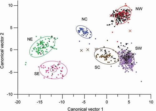
Table 5. Summary of subregional mean climatic data from PRISM climate model (1981–2010 normals, Daly, Neilson, and Phillips Citation1994). For overall means and range of values, boldface is annual, light shading is summer, and dark shading is winter
Figure 3. Scatter plots showing range of mean climate values for extant (grey dots), extirpated (black crosses), and old (black dots) Great Basin sites, as represented by PRISM tiles that include the sites. (A) Annual precipitation versus summer precipitation. (B) Summer minimum temperature versus summer maximum temperature. (C) Winter minimum temperature versus winter maximum temperature
Table 6. Correlations of elevation with climate variables in Great Basin subregions. Climate values derive from the PRISM climate model (1981–2010 normals; Daly, Neilson, and Phillips Citation1994)
Figure 4. Discriminant analysis of extant American pika locations by mountain ranges within six subregions of the hydrographic Great Basin. Dots are pika sites as represented by PRISM tiles; many tiles overlap. Larger ellipsoids indicate 50 percent concentration of the points; smaller (inner) ellipsoids indicate 95 percent confidence intervals of the means; plus symbols indicate the center of concentrations
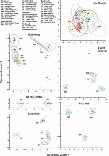
Table 7. Mountain ranges within Great Basin subregions that contain extirpated pika sites
Table 8. Mountain ranges within Great Basin subregions that contain old pika sites
Table 9. Great Basin mountain ranges where evidence for pika presence has not been detected during twentieth- and twenty-first-century surveys. High point elevations from D.A. Charlet (unpublished, Atlas of Nevada Mountains)