
Figures & data
Figure 1. Map of the hydrographic Great Basin study region, United States, showing mountain ranges containing rock glaciers, ranges with persistent ice fields (marked with *), and eight subregions used in analysis. Mountain ranges are defined in . Subregions: SN = Sierra Nevada (not enclosed by polygon); SW = southwest; NW = northwest; SC-W = south-central west; SC-E = south-central east; NC = north central; NE = northeast; SE = southeast.
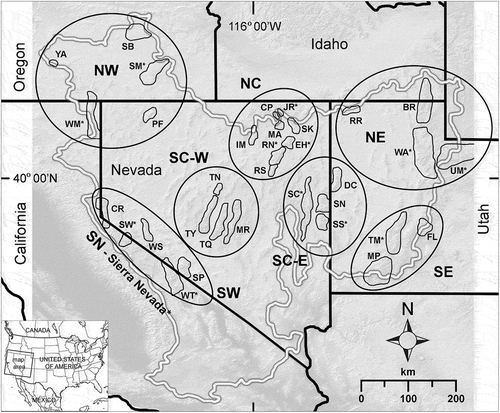
Figure 2. Examples of rock-glacier morphology types mapped in the Great Basin. (a) Cirque rock glacier (RGC); (b) crest-headwall rock glacier (TALC); (c) valley wall rock glacier (TALV; protalus rampart).
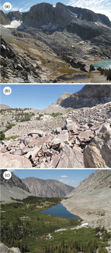
Figure 3. Examples of condition types estimated for features mapped in the Great Basin. (a) Active (A1), Mt. Gibbs, Sierra Nevada, California; (b) active front (A1), Mammoth Crest, Sierra Nevada, California; (c) likely active (A2), Moores Canyon, Toquima Range, Nevada; (d) relict (R), Cougar Peak, Jarbidge Range, Nevada.
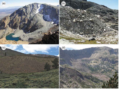
Table 1. Geographic attributes for rock glaciers of the Great Basin. Intact rock glaciers include condition classes A1 and A2; relict rock glaciers are class R.
Table 2. Geographic attributes for persistent ice fields of the Great Basin.
Figure 4. Discriminant analysis of subregions in the hydrographic Great Basin ( for subregion names) and twenty-five PRISM climate variables ( for variables). Dots are PRISM climate tiles containing rock-glacier sites; overlapping sites are contained in many of the single dots: NE = purple; SE = green; SC-E = brown; SC-W = gold; NC = light green; NW = blue; SW = pink; SN = yellow-green. Larger ellipsoids indicate 50 percent concentration of the points; smaller (inner) ellipsoids indicate 95 percent confidence intervals of the class means. The mean misclassification rate was 1.4 percent.
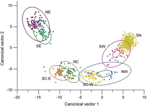
Figure 5. Discriminant analysis of rock-glacier condition classes in the hydrographic Great Basin and twenty-five PRISM climate variables (see Table 3). Dots are PRISM climate tiles containing rock-glacier sites; overlapping sites are contained in many of the single dots. Class A1 (active) = brown; class A2 (inactive) = purple; class R (relict) = green. Larger ellipsoids indicate 50 percent concentration of the points; smaller (inner) ellipsoids indicate 95 percent confidence intervals of the class means. The mean misclassification rate was 39 percent.
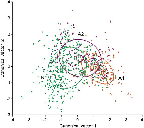
Table 3. Summary of mean climatic data by subregions, rock-glacier condition class, and overall for the Great Basin (GB). Data extracted from PRISM climate model (1981–2010 normals, Daly, Neilson, and Phillips Citation1994). Subregions: NC = north-central; NE = northeast; NW = northwest; SC-E = south-central east; SC-W = west-central west; SE = southeast; SN = Sierra Nevada; SW = southwest. Classes: A1 = active; A2 = inactive; R = relict.
Table 4. Water volume estimated for rock glaciers and persistent ice fields of the Great Basin. For rock glaciers, volume was calculated only for features assessed as intact (condition classes A1 or A2). Blank cells indicate mountain ranges without active rock glaciers or without ice fields.