Figures & data
Figure 1. Plan view of the study area and study site. (a) Overview map of the European Alps with the small rectangle indicating the location of the study area. (b) Section of the topographic map covering the study area (large rectangular frame) within which the transect along the measuring plots (squares)—that is, the study site—is delineated by the two dashed lines. The flags pointing to the squares indicate elevation, slope aspect (north or south), land cover (open field or forest). Note the separate plots for field and forest at 1,058 m a.s.l. on the S slope, because the measurements in the field and forest were not adjacent here. The coordinates of the grid lines in map (b) are given in the Swiss coordinate system (normal font) and the World Geodetic System (WGS84; italics). Source of background maps: (a) Google Maps (© Google, Citationn.d.) and (b) Swiss Federal Office of Topography (© swisstopo, Citation2018). Fi = open field; Fo = forest
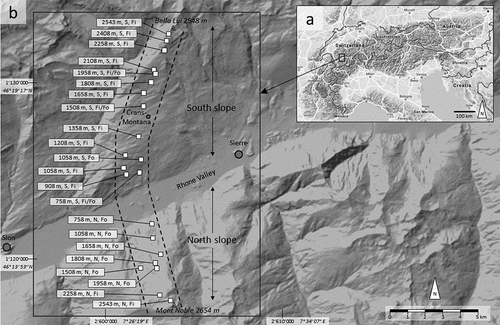
Figure 2. Elevational cross-profile through the Rhone valley near Sierre () along the measurement transect. South slope = southern exposed (S) slope; North slope = northern exposed (N) slope
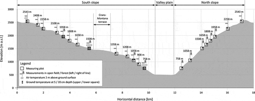
Table 1. Thermal air and ground parameters analyzed in this study
Figure 3. Typical subdaily air and ground temperature courses in summer at the lowermost and uppermost ends of the elevational transect on the S slope in the field. Note that the measurement resolution was 2 hours. Dates (d/m/y)
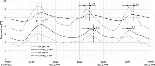
Figure 4. Air and ground temperature courses on the basis of daily mean values and snow cover period at the lowermost and uppermost ends of the elevational transect on the S slope in the field. Dates (d/m/y)
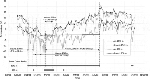
Figure 5. Periods of snow cover for the measuring plots along the elevational gradient. In order to distinguish the bars of different aspects and land covers at the same elevation those for “north, field,” “north, forest,” and “south, forest” are displayed slightly shifted vertically and those for “south, field” are displayed at the real elevation. Braces indicate bars at the same elevation. Dates (d/m/y)
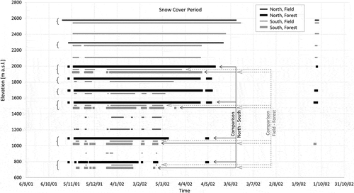
Figure 6. Diagrams for regressions of air and ground thermal parameters on elevation. All data refer to the S slope and the open field. Winter refers to data from December to February; summer refers to data from June to August. Note that if regressions are based on interpolated data or if an exponential regression line was fitted to the data, no coefficient of determination, R2, could be calculated. Gray shading for data points and regression lines for significance levels: black for p ≤ .05, dark gray for .05 < p ≤ .1, light gray for p > .1, where the smallest p value of the coefficients in the regression equation is decisive. Data containing interpolated points and their regression lines are drawn in light gray
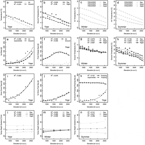
Figure 7. Diagrams for regressions of air and ground thermal parameters on elevation with respect to slope aspect. Air data refer to the open field and ground data to forest and 5 cm depth below surface. Gray shading for data points and regression lines for significance levels regarding the difference between north and south: black for p ≤ .05, dark gray for .05 < p ≤ .1, light gray for p > .1, where the smallest p value of the regression coefficients is decisive
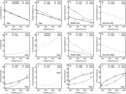
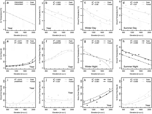
Figure 8. Diagrams for regressions of air and ground thermal parameters on elevation with respect to the land cover. All data refer to the S slope and ground data refer to 5 cm depth. Gray shading for data points and regression lines for significance levels regarding the difference between field and forest: black for p ≤ .05, dark gray for .05 < p ≤ .1, light gray for p > .1, where the smallest p value of the regression coefficients is decisive. Filled large circles in (a), (i), (j), and (l) indicate that data points for field and forest are superimposed