Figures & data
Table 1. Number of plots, fire scars sampled, and the years each plot burned at our two study regions on the Seward Peninsula, Alaska
Figure 1. Map of study sites on the Seward Peninsula, Alaska. Plots and fire scars are shown at (A) the end of the Kougarok road (Seward Peninsula West) and (B) Buckland River (Seward Peninsula East). The Minguk River fire scar (2010s), which burned in 2016 (Seward Peninsula West), is shown on the map, though sites were visited prior to this fire.
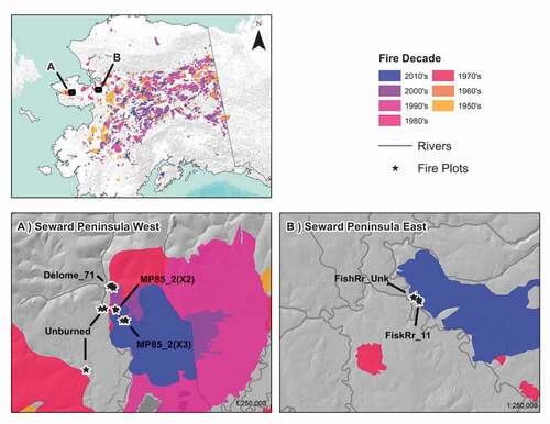
Figure 2. NMDS ordination of all sites. Three axes captured approximately 86 percent of the variance in species composition across all plots. Ordinations were correlated with environmental and vegetation characteristics and grouped by vegetation class. Strong Kendall correlations (r2 > 0.25) with the ordination axes are indicated by biplot vectors where plots are grouped by vegetation class showing (a) Axis 1 vs. Axis 2 and (b) Axis 2 vs. Axis 3.
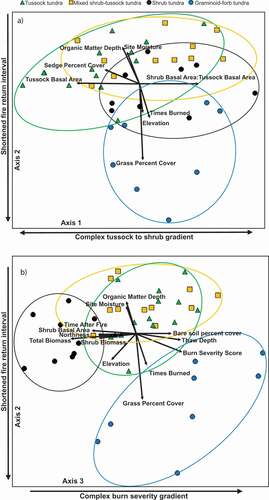
Figure 3. Mean absolute cover of plant functional type, with plots grouped by time after fire, burn severity, and times burned classes.
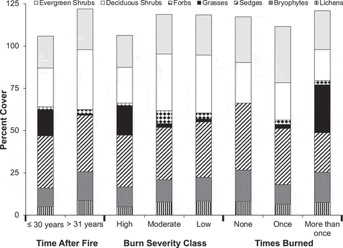
Figure 4. The response of belowground ecosystem characteristics to increased fire effects. Fire effect is a composite variable based on time after fire, number of times burned, and burn severity. Solid lines indicate significant relationships (p < .05), and dashed lines indicate marginally significant relationships (0.1 > p > .05). (c), (d), (f) represent profile-weighted pools. Surf = surficial (upper 5 cm of soil).
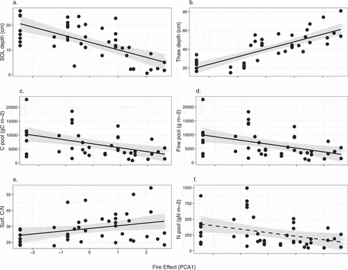
Figure 5. Response of aboveground vegetation characteristics to increased fire effects. Fire effect is a composite variable based on time after fire, burn severity, and times burned. Solid lines indicate significant relationships (p < .05).
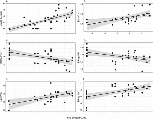
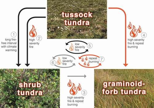
Figure 6. Post-fire successional trajectories in Alaska arctic tundra. Arrows 1–4 depict trajectories among vegetation types and arrows 5–7 depict fire regimes that maintain existing vegetation. Colors represent observed (black), hypothesized (gray), and novel (orange) pathways. The trajectories among vegetation types include (1) tussock tundra to shrub tundra with a long fire-free interval and climate warming through a shift in dominance of existing shrubs and subsequent shading, accumulation of deciduous leaf litter, and loss of the understory (Epstein et al. Citation2004); (2) tussock tundra to shrub tundra after high-severity fire through combustion of vegetation and soil organic layers, thereby exposing mineral soil and facilitating shrub recruitment (e.g., Landhausser and Wein Citation1993; Racine et al. Citation2004; Jones et al. Citation2013); and (3), (4) tussock tundra (this study) and shrub tundra to a novel graminoid–forb tundra after high severity fire and repeat burning. (5), (6) Fire regimes that maintain existing vegetation include low-severity fire maintains tussock tundra (e.g., Bret-Harte et al. Citation2013; this study) and shrub tundra and their vegetation and ecosystem properties (7) and a short fire return interval (this study) maintains graminoid–forb tundra with its distinct vegetation and ecosystem properties.