
Figures & data
Figure 1. Map of the central Sierra Nevada, California, with location of the Kavanaugh Plateau and patterned-ground study site east of the range crest in Mono County.
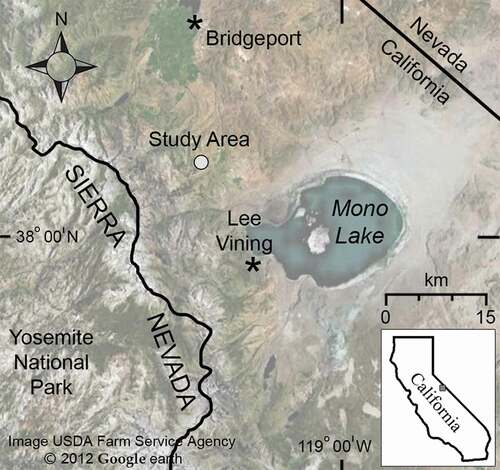
Figure 2. Overview of Kavanaugh Plateau and Dunderberg Peak. The patterned-ground study site (polygon) lies on the shallow slope in the middle of Kavanaugh Plateau and is surrounded by regions of higher relief. (a) View north toward Kavanaugh Ridge (3,389 m). (b) View south–southwest to Dunderberg Peak (3,772 m). Taluses on adjacent slopes that were monitored for pika activity are noted with asterisks.
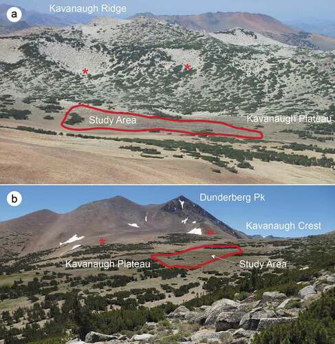
Figure 3. Overview of Kavanaugh Plateau patterned-ground study area. Ribbon forest, snowbed slope with snowdrift, soil circles, and rock wells are visible in this westward view.
Figure 4. Zones delineated for physical and ecological measurements, Kavanaugh Plateau. Ribbon forest, snowbed slope, forefield meadow, terrace rampart, and patterned-ground zones are indicated.
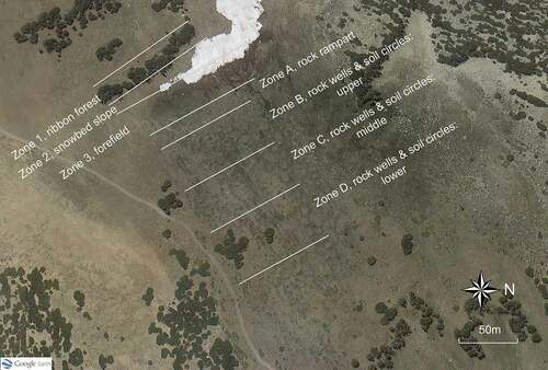
Figure 5. Features of the patterned-ground ecosystem within the Kavanaugh Plateau study area. (a) Edge of ribbon forest and snowbed slope. (b) Forefield meadow. (c) Rock terrace rampart. (d) Patterned ground with soil circles and rock wells. All views are southward.
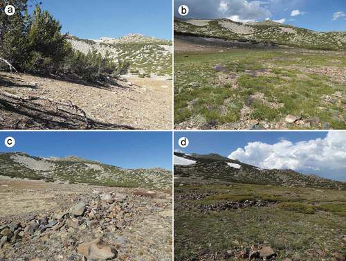
Figure 6. Rock well springs in the patterned ground zones. Following spring snowmelt from most slopes of the Kavanaugh Plateau except the snowbed, multiple springs across the patterned-ground zones emerge from rock wells and flow a short distance onto soil circles below them. (a) View westward to the ribbon forest and snowpack remaining on the snowbed slope (14 July 2017). (b) View eastward of a spring in the lower portion of the patterned-ground zones showing the water flow onto downslope soil circle (3 July 2019).
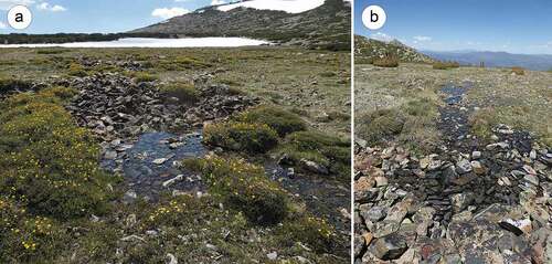
Figure 7. Types of patterned ground in study area. (a) Unsorted circles in the upper portion of the study area. Rock wells are mostly discontinuous and do not always surround soil circles. View westward to the rock rampart, snowbed slope, and ribbon forest. (b) Sorted circles in the lower portion of the study area. Rock domains border the soils circles and are mostly continuous with other rock domains across the slope. View northward.
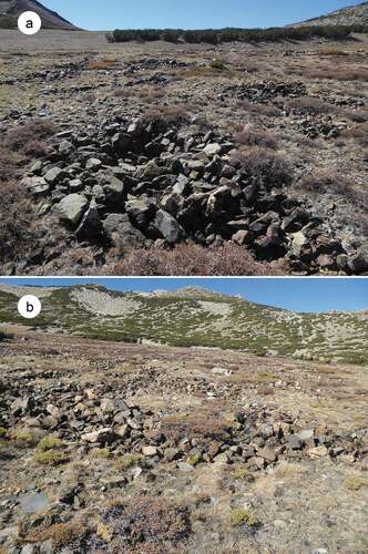
Figure 8. Temperatures from four positions in the Kavanaugh Plateau study site. (a) Air temperature recorded at 2.5 m in the ribbon forest. (b) Forefield meadow (buried). (c) Soil circle (buried). (d) Rock well springhead.
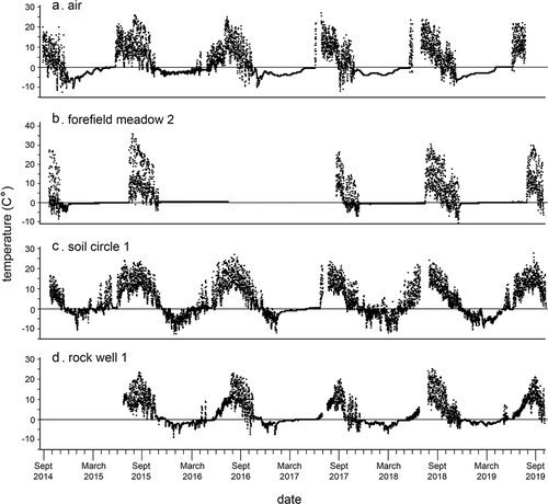
Figure 9. Temperatures from one Kavanaugh Plateau haypile site, September 2014 to September 2019. Missing data are either failures of datalogger or gaps in exchange of units. (a) Haypile surface. (b) Haypile matrix.
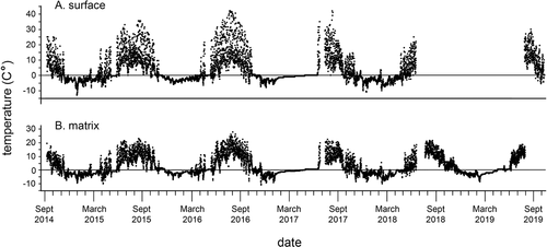
Figure 10. Fresh haypiles in rocky borders of sorted and unsorted circles, 21 September 2014. (a) Haypile in upper unsorted circle (Zone B). (b) Haypile in lower sorted circle (Zone D).
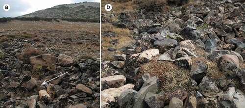
Figure 11. Location of fifty-three haypiles, including old and fresh, on the patterned-ground ecosystem. Cumulative across seven years of observations.
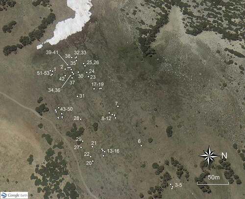
Figure 12. Number of haypiles observed on the patterned-ground zones from 2014 to 2020, freshness of vegetation in the haypiles, and relative size of fresh haypiles. Ranks: 0, old haypile; 0.5, one-year-old haypile; 1–5, fresh (green) haypiles by relative size, from 1 (smallest) to 5 (largest).
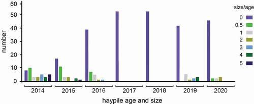
Figure 13. Cross-section views of the Kavanaugh Plateau showing stratification of substrates. A solid granitic formation dips under the unconsolidated metamorphic substrate of the patterned-ground slope in the central portion of the plateau. (a) Photo taken from a promontory on the edge of Kavanaugh Crest looking back (southeast) toward the plateau. (b) Google Earth image showing the shallow central slope with the substrate stratification (in circle; view northeast). The snowbed with snowdrift still present is in the middle of the slope and the patterned-ground ecosystem lies beyond (east) it at arrow. Google Earth image, 11 August 2017.
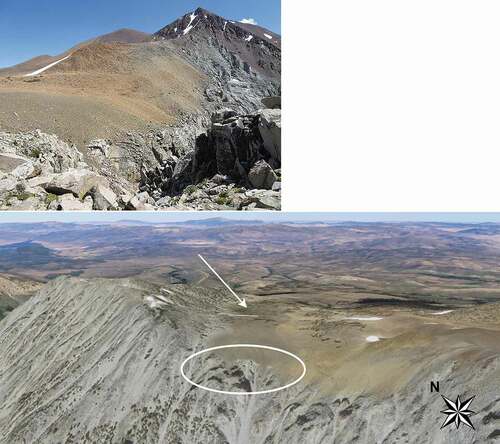
Table 1. Physical measurements
Table 2. Significance values for select statistical tests of differences between class means of physical features in the study area. See for location of zones
Table 3. Temperatures at six features of the Kavanaugh Plateau study area, 2014–2019. Mean annual daily temperatures and seasonal daily temperatures, with standard deviations, minima, and maxima
Table 4. Annual and seasonal air temperatures (2.0 m in ribbon forest) for 2015–2018. Data for 2014 and 2019 are incomplete due to duration of study
Table 5. Seasonal dates of (A) onset of snow cover in autumn/winter and spring/summer melt date of snow from soils of the slope above the ribbon forest, forefield meadow below the ribbon forest, and soil circles. Forefield meadow: west transect, 1–3; center, 4–5; east, 6–9. (B) onset and dessication of waterflow in rock wells and rocky matrices below pika haypiles
Table 6. Freezing days and freeze–thaw events. Number of days when temperatures were <0°C and number of freeze–thaw days at four positions of the Kavanaugh Plateau study area
Table 7. Ribbon forest tree ages, diameters, density, basal area, and tree cover, Kavanaugh Plateau study area. Odd numbered plots were on the west side of the ribbon (windward); even numbered plots were on the east side
Table 8. Plant cover, species list and functional traits at Kavanaugh Plateau patterned-ground ecosystem ecosystem and on adjacent pika habitat
Table 9. Pika haypiles at the Kavanaugh Plateau patterned ground ecosystem, 2014–2020. Haypile numbers correspond to locations in