Figures & data
Figure 1. (a) Map of the central Rocky Mountains showing the location of our study area in west-central Colorado; inset map of North America. (b) Location of the Ziegler Reservoir fossil site just west of the town of Snowmass Village, Colorado, on the divide between Snowmass Creek Valley to the west and the Brush Creek drainage to the east. The extent of the Snowmass Creek Valley glacier during Bull Lake (MIS 6) is shown in gray (after Bryant Citation1979). Colored polygons represent areas where glacial deposits were sampled to test for provenance; Snowmass Creek Valley (blue), Roaring Fork Valley (light brown), and the Roaring Fork–Carbondale area (green). Locations of loess deposits on Mt. Sopris (Birkeland Citation1973) and the Aspen Highlands Ski property (McCalpin and Irvine Citation1995) are also shown.
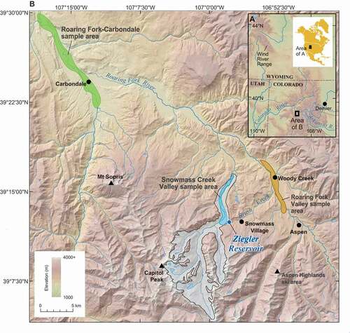
Figure 2. Oxygen isotope ratios (δ18O) of marine foraminifera over the past 200 ka (Imbrie et al. Citation1993). Age constraints for MIS 1 to 6 are based on Lisiecki and Raymo (Citation2005), with the cold stages highlighted in blue and the cooler substages of MIS 5 highlighted in light blue. The North American continental glacial episodes and Rocky Mountain glacial stages are shown below the MIS stage numbers in their approximate temporal positions (Pierce Citation2003). Finally, the age span of the Ziegler Reservoir sediments is depicted by the bracket.
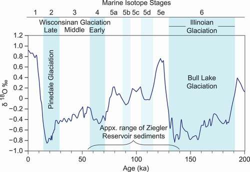
Figure 3. View of the Ziegler Reservoir fossil site looking to the southwest. Note the fortuitous location of the site where the Bull Lake glacier overtopped a ridge but did not descend down Brush Creek drainage to the east. Also note the mass wasting event on the Bull Lake (MIS 6) lateral moraine on the right side of the image. The location of Capitol Peak is shown in for spatial reference. Image generated using Google Earth.
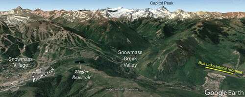
Figure 4. Generalized cross section of the Ziegler Reservoir sedimentary sequence at the end of MIS 4 (after Pigati et al. Citation2014). The Bull Lake moraine is shown with several postdepositional debris flows, or slumps, emanating into the center of the basin where they interfinger with fine-grained basin sediments. The box shows the approximate location of the composite stratigraphy included in .
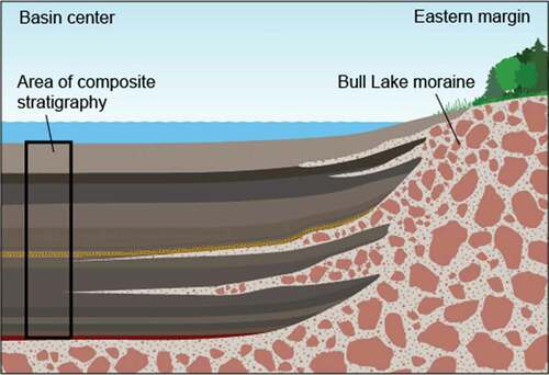
Figure 5. Composite stratigraphy, chronology, SAR, and particle size data for the fine-grained sediments of the Ziegler Reservoir fossil site. Ages for the sediments are based on the age -depth model of Mahan et al. (Citation2014). MIS are based on ages from Lisiecki and Raymo (Citation2005) and are also positioned according to the age -depth model of Mahan et al. (Citation2014). Cold MIS stages are shown in blue and the cool substages of MIS 5 are in light blue. Detailed unit descriptions can be found in Pigati et al. (Citation2014).
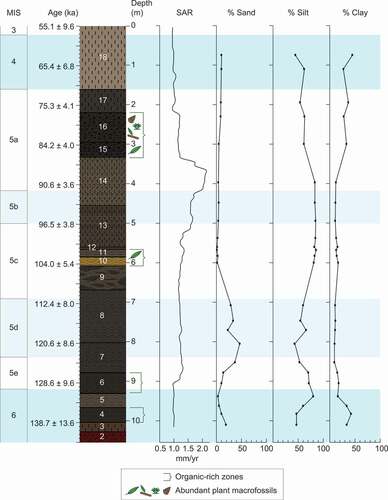
Figure 6. Ternary diagram of particle size distributions for the Ziegler Reservoir sediments, loess deposits at Mt. Sopris (Birkeland Citation1973) and the Aspen Highlands ski area (McCalpin and Irvine Citation1995), loess standards from the Quaternary Materials Laboratory of the University of Iowa, and modern dust.
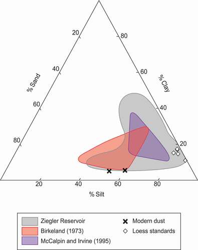
Figure 7. (a) Mineralogy (excluding quartz) of silt from the Ziegler Reservoir sediments (n = 30) compared to silt mineralogy from the three potential provenance areas (Snowmass Creek Valley, n = 11; Roaring Fork Valley, n = 13; and the Roaring Fork–Carbondale area, n = 13), silt from the moraine surrounding the basin, and modern dust. (b) Clay mineralogy for the Ziegler Reservoir (n = 23) sediments compared to the potential provenance areas (Snowmass Creek Valley, n = 3; Roaring Fork Valley, n = 3; and the Roaring Fork–Carbondale area, n = 4) and the impounding moraine (n = 2). The dust trap samples were not large enough for clay mineral analysis. (c), (d) Ratios of select elemental concentrations from the silt fraction of the Ziegler Reservoir sediments (n = 30), provenance areas (Snowmass Creek Valley, n = 9; Roaring Fork Valley, n = 14; and the Roaring Fork–Carbondale area, n = 13), the impounding moraine (n = 2), and modern dust (n = 1).
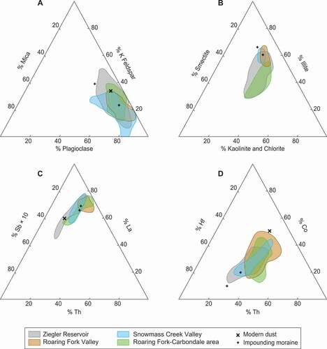
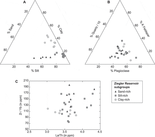
Figure 8. Results of (a) particle size analysis, (b) mineralogical determinations, and (c) select trace elements for subgroups of the Ziegler Reservoir sediments. The subgroups were based on the dominant grain size of the units from which the samples were taken and include sand-rich, silt-rich, and clay-rich sediments. Mineralogical and elemental data are based on results from the silt-sized particles from each subgroup. The lack of differentiation between these groups suggests that the source areas likely did not change between late MIS 6 and early MIS 3.