Figures & data
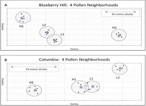
FIGURE 1 Physical map of Blueberry Hill (top) and Columbia (bottom), showing the locations of the eight pollen neighborhoods and the precise locations of the five clones comprising each neighborhood and the central focal recipients. Neighborhood areas, as measured by the area internal to a linear perimeter connecting the five donors, ranged from 30.2–110.7 m2 with a mean area of 69.7 m2. Scale insets are also shown. The designations H1, H2, L1, and L2 indicate relative natural yield potential under open pollination conditions (fruit set)—H for high, L for low. Blueberry Hill and Columbia are approximately 12.5 km apart (color figure available online).