Figures & data
Figure 1. The study area extends along the coasts of the Coorong, Fleurieu Peninsula and Kangaroo Island (South Australia). Smaller map shows the location of the study area within the Asia-Pacific region.
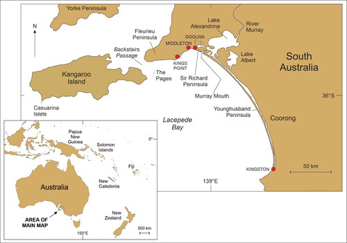
Table 1. Synonyms and name variants for key people and places in the Ngurunderi narrative.
Figure 2. Islands off the southeast Fleurieu Peninsula.
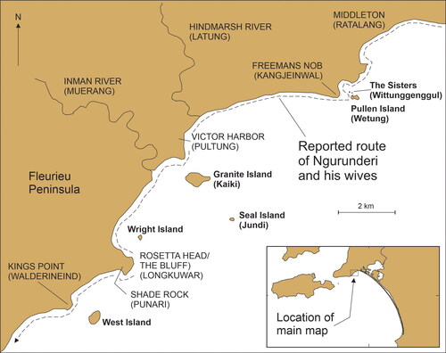
Figure 3. Photos of islands off the southeast coast of Fleurieu Peninsula (A–E) and one (F) showing the coastal route taken by Ngurunderi and his wives from Rosetta Head to Newland Head (all photos by Patrick Nunn).
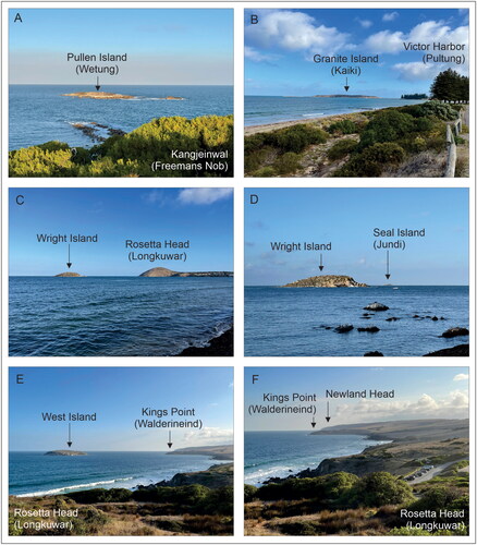
Figure 4. Geography of the western Fleurieu Peninsula, Backstairs Passage and the Pages.
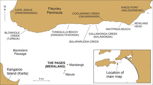
Figure 5. Islands off Cape du Couedic, Kangaroo Island.
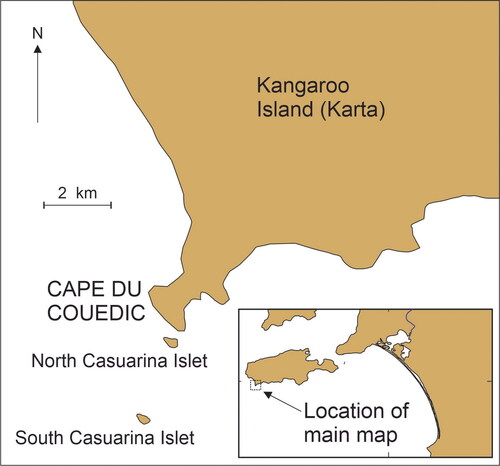
Figure 6. Sea-level changes around the coast of Australia within the past 13,000 years (after Lewis et al. Citation2013; Nunn and Reid Citation2016); the blue/shaded envelope represents the uncertainty of sea levels at particular points in time. Red/shaded boxes show the sea levels (as in ) at which each of the eight island-formation stories and that referring to the crossing of Backstairs Passage would most recently have been true. Ages in are calculated graphically from this figure.
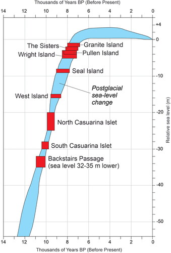
Table 2. Nearshore islands referenced as having been created/visited by Ngurunderi with details of minimum depths that allow calculation of minimum ages for islandization (from ).
Figure 7. Current bathymetry of Backstairs Passage showing its geography today and when sea level was 10, 20 and 30 m lower. Based on published depth soundings (from Australian Hydrographic Service chart AUS126 [2010]), a land bridge across Backstairs Passage would have existed when the sea level was 32–35 m lower, estimated to have been at least 10,100–11,000 years ago (see and ). A likely crossing route is shown as a dashed line and suggests that the detail in most versions of the Ngurunderi narrative stating that this route began at Blowhole Creek (Tjirbuk) is correct.
![Figure 7. Current bathymetry of Backstairs Passage showing its geography today and when sea level was 10, 20 and 30 m lower. Based on published depth soundings (from Australian Hydrographic Service chart AUS126 [2010]), a land bridge across Backstairs Passage would have existed when the sea level was 32–35 m lower, estimated to have been at least 10,100–11,000 years ago (see Figure 6 and Table 2). A likely crossing route is shown as a dashed line and suggests that the detail in most versions of the Ngurunderi narrative stating that this route began at Blowhole Creek (Tjirbuk) is correct.](/cms/asset/b61b94df-4fb8-41d8-9893-c1057ada7977/uica_a_2337096_f0007_c.jpg)
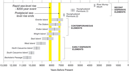
Figure 8. Dated elements of the Ngurunderi narrative arranged in descending-age order. Three groups of elements may be significant in understanding the evolution of the Ngurunderi narrative. The middle group (contemporaneous elements) may have been associated with rapid sea-level rise during the 8200-year event and the later group (recent disparate elements) with the end of postglacial sea-level rise.