Figures & data
Figure 1. Layout and monitoring network ‘Tuindorp’ catchment.
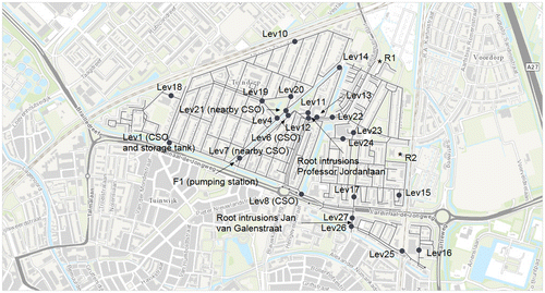
Table 1. Main characteristics ‘Tuindorp’ catchment.
Figure 2. Storm events and works ‘Tuindorp’ sewer system for 1 October 2008–6 October 2015.
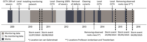
Figure 3. Calibration process (after Hemker, Citation1996).
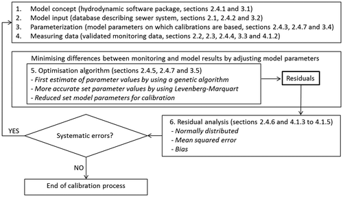
Figure 4. Rainfall runoff model (Stichting RIONED, Citation1999).
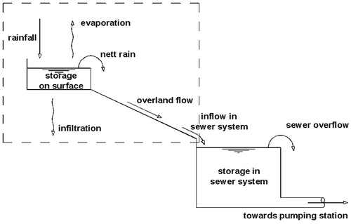
Figure 5. Outgoing discharge ‘Tuindorp’ pumping station based on flow and water level measurements at the pumping station for June 2014–May 2015.
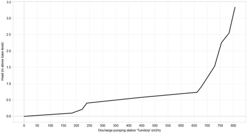
Figure 6. Observed storm events for model calibration (11/07/2010, 26/08/2010, 05/05/2015 and 04/09/2015) and obtaining the reduced parameter set (24/09/2014).
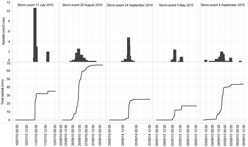
Table 2. Parameter set for calibration of the hydrodynamic model.
Figure 7. Local hydrological circumstances on roofs affecting total amount of runoff water (vegetation and storage).
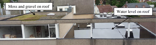
Figure 8. Average daily dry weather flow on the ‘Tuindorp’ catchment.
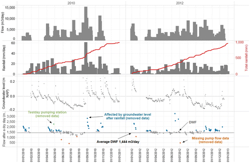
Figure 9. Daily pattern dry weather flow on the ‘Tuindorp’ catchment for 2010 and 2012.
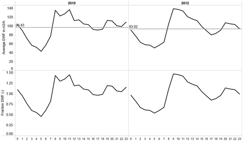
Figure 10. Correlation matrix full parameter set storm event 24/09/2014.
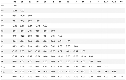
Figure 11. Correlation matrix reduced parameter set storm event 24/09/2014.
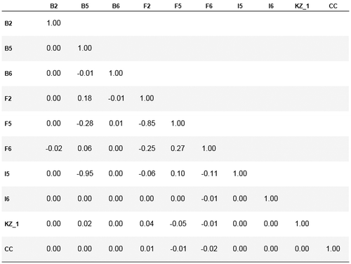
Figure 12. Measured and calibrated water levels Lev7 storm event 04/09/2015.
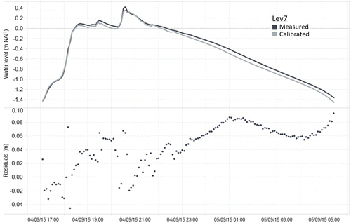
Figure 13. Measured and calibrated water levels Lev10 storm event 04/09/2015.
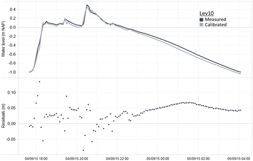
Figure 14. Measured and calibrated water levels Lev19 storm event 04/09/2015.
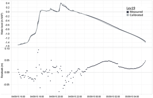
Figure 15. Normal probability plots of residuals after calibration of the clean system (storm events 05/05/2015 and 04/09/2015) and the system including defects (storm events 11/07/2010 and 26/08/2010).
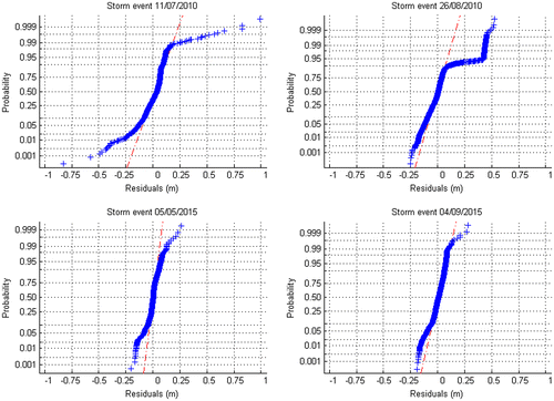
Figure 16. Bias and MSE for location Lev19 during storm event 04/09/2015.
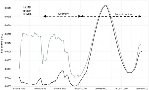
Table 3. Correlation between measured water levels up and downstream the observed root intrusion at Professor Jordanlaan and Jan van Galenstraat for storm event 11/07/2010.
Table 4. Correlation between residuals after calibration up and downstream observed root intrusion at Jan van Galenstraat for storm event 11/07/2010.
Table 5. Correlation between residuals after calibration up and downstream observed root intrusion at Jan van Galenstraat for storm event 26/08/2010.
Table 6. Correlation between residuals after calibration up and downstream observed root intrusion at Professor Jordanlaan for storm event 11/07/2010.
Table 7. Correlation between residuals after calibration up and downstream observed root intrusion at Professor Jordanlaan for storm event 26/08/2010.
Figure 17. Mean value of residuals per event after calibration of the clean system (events 05/05/2015 and 04/09/2015) and the system including in-sewer defects (events 11/07/2010 and 26/08/2010).
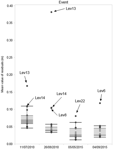
Figure 18. Mean value of residuals per sensor after calibration of the clean system (events 05/05/2015 and 04/09/2015) and the system including in-sewer defects (events 11/07/2010 and 26/08/2010).
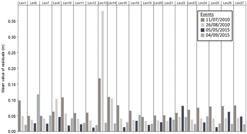
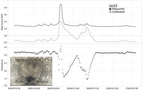
Figure 19. Measured and modelled (calibrated) water levels upstream (Lev13) root intrusion at Professor Jordanlaan for event 26/08/2010. NAP is reference level.