Figures & data
Fig. 1. Weighting functions for the nine infrared channels 7–16. The 43 WRF–ARW model levels from surface to 50 hPa are shown in grey horizontal lines and the layer thicknesses are shown by black dashed curve.
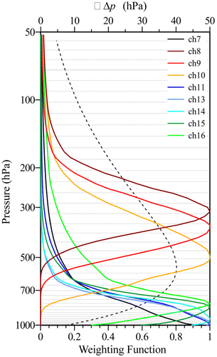
Fig. 2. The observations of 12-h accumulative rainfall amounts over land (shaded) ending at and the 500 hPa geopotential height from NCEP FNL at (a) 0000, (b) 1200 and (c) 2400 UTC 3 July 2016 (contour interval: 10 m). The dashed rectangle shows the validation area.
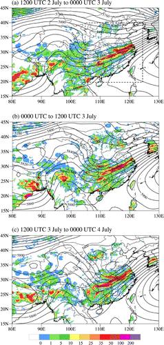
Fig. 3. (a) Spatial distribution of brightness temperature observations of AHI channel 16 at 0000 UTC 1 July 2016 within the model domain. (b) Schematic illustration of the data assimilation cycling from 0000 UTC 1 July to 0000 UTC 2 July 2017 and the forecast experiments initialized at 0000 UTC 2 July 2017.
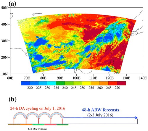
Fig. 4. (a) Clouds detected by the 11 infrared only cloud mask algorithm which is implemented for AHI data assimilation and (b) cloud mask (blue) obtained by CLAVR-x at 2300 UTC 1 July 2016.
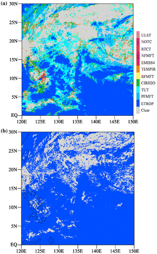
Fig. 5. (a) Mean and (b) standard deviation of the differences between AHI observations and model simulations before (red bars) and after (blue bars) data assimilation in the AHIA experiment. All data assimilated during the one-day cycling period (black circles) are included.
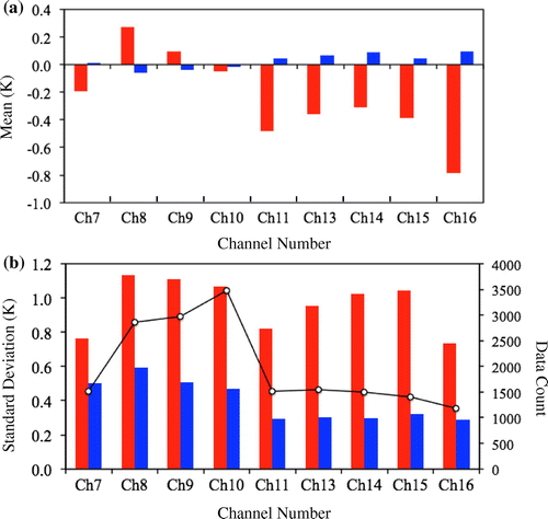
Fig. 6. Spatial distribution of (a, b) O–B and (c, f) O–A of channel 9 (left panels) and channel 10 (right panels) from (c, d) AHIA and (e, f) AHIG experiments at 0000 UTC 1 July 2016, which is the beginning time of the AHIA data assimilation cycling. Black dots represent data rejected by QC.
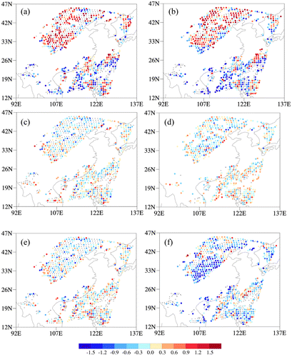
Fig. 7. (a, b) Spatial distributions of the analysis of water vapor mixing ratio (black contour), the analysis of wind (vector), and the analysis increments (colour shading) of water vapor mixing ratio (contour interval: 1.0 g kg−1) at σ = 0.743 (~750 hPa) at 0000 UTC 1 July 2016 (i.e. the beginning of the one day DA cycle) from (a) CTRL and (b) AHIA experiments. (c) Cross sections of the water vapor analysis differences between the AHIA and CTRL experiments (colour shading) and the AHIA analysis increments (curve, contour interval: 0.4 g kg−1) along the 115E longitude at 0000 UTC 1 July 2016. (d) Same as (c) except for AHIG.
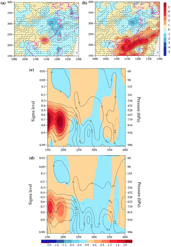
Fig. 8. Same as Fig. 7 except for the atmospheric temperature. The contour interval is 1 K for (a, b) and 0.1 °C for (c, d).
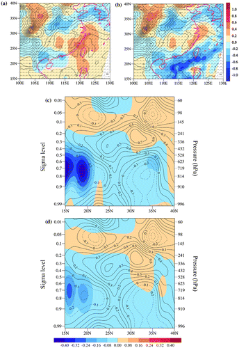
Fig. 9. Forecasts of water vapor mixing ratio at σ = 0.743 (~750 hPa) from the AHIA (left panels) and AHIG (right panels) experiments (contour interval: 1 g kg−1), as well as the forecast differences between the AHIA and CTRL experiments (colour shading, left panels) and the forecast differences between the AHIG and CTRL experiments (colour shading, right panels) from 0000 UTC 2 July to 0000 UTC 2 July 2016 at 12-h interval.
Fig. 10. Vertical and latitudinal cross sections along the 115E longitude for the analysis of water vapor mixing ratio of the AHIA experiment (contour interval: 1 g kg−1) and the forecast differences of water vapor mixing ratio between the AHIA and CONV experiments (AHIA-CTRL, shaded) at (a) 0000 UTC, (b) 1200 UTC and 1800 UTC 2 July 2016. The 3-h accumulative rainfall observations (purple curve) ending at (a) 0000 UTC, (b) 1200 UTC and (c) 1800UTC 2 July 2016 are indicated by the y-axis on the right by a logarithmic scale.
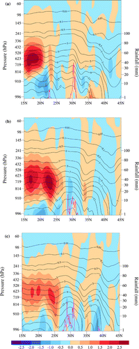
Fig. 11. The 12-h accumulative rainfall amounts over land (colour shading) from the AHIA (left panels) and AHIG (right panels) experiments from 1200 UTC 2 July to 0000 UTC 3 July (top panels), 0000 UTC 3 July to 1200 UTC 3 July (middle panels), and 1200 UTC 3 July to 0000 UTC 4 July (bottom panels) 2016, as well as the geopotential height (black curve) at 500 hPa at the ending time of each of the three 12-h intervals.
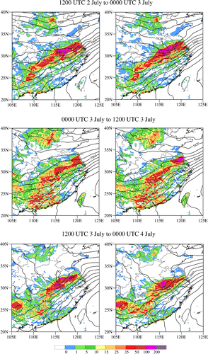
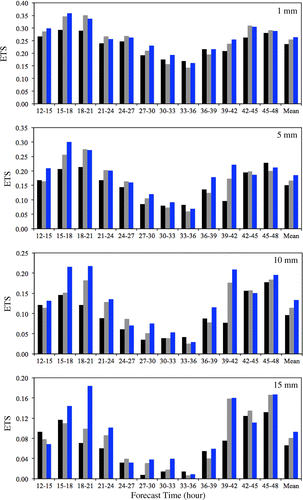
Fig. 12. Equitable threat scores (ETS) for the 3-h accumulative rainfall amounts over land at the thresholds of 1, 5, 10 and 15 mm during the 12–48 h forecasts, which are initialized at 0000 UTC 2 July 2016, from the CONV (black bars), AHIG (grey bars) and AHIA (blue bars) experiments from 1200 UTC 2 July to 0000 UTC 4 July 2016.