Figures & data
Table 1. Gradient check.
Figure 1. Computational domain overlay with topography height. Verification only computed in the red gridded region.
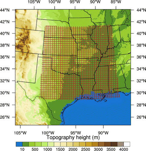
Figure 2. Horizontal length scales for the 45 leading modes of the vertical EOF decomposition of the background error covariances for U, V, temperature (T) and relative humidity (RH). (WRF horizontal grid spacing: 4 km)
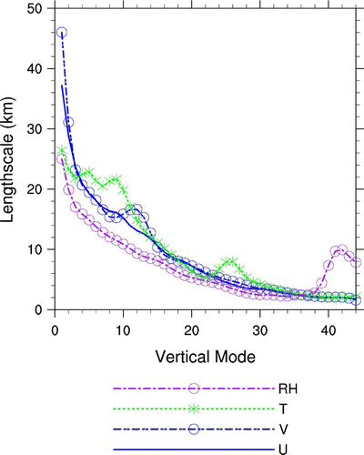
Figure 3. Geopotential height (blue solid contours every 20 gpm), temperature (shaded contours), relative humidity (red line, greater than 60% is shown in 500 hPa, and greater than 80% is shown in 850 hPa) and wind (in knots) at 0000 UTC 9 June 2010 at (a) 500 hPa and (b) 850 hPa. Non-colour areas indicate the 850 hPa surface was underground.
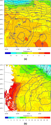
Figure 4. NCEP Stage-IV 6-h accumulated precipitation (mm) valid at 0600 UTC 9 June 2010. The maximum rainfall is over 200 mm in Kansas. The original precipitation accumulations are available on a 4-km resolution polar stereographic grid and it has been regridded to lambert conformal grid.
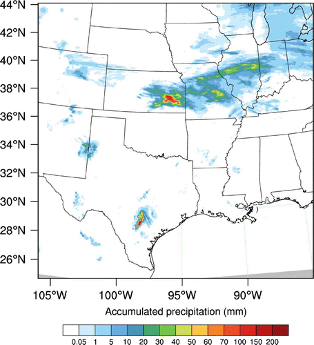
Figure 5. 1-h accumulated precipitation from WRF non-linear model valid at 0100 UTC 9 June 2010. Two black marks denote precipitation location for single observation tests. Location_1 (37.95N, 95.13
W) is for experiment SOBS1 and SOBS2. Location_2 (38.5
N, 95.13
W) is for experiment SOBS3. Model precipitation at location_1 and location_2 is about 56 mm and 3.18 mm, respectively.
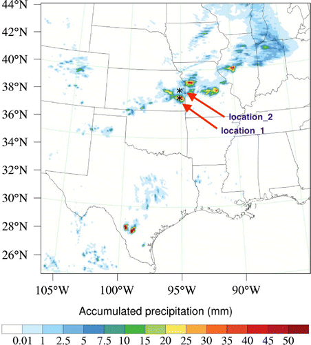
Figure 6. Analysis increments in the east–west vertical cross section at observation location (37.95N, 95.13
W) for the experiment SOBS1: (a) temperature and (b) moisture. The maximum and minimum of the variables are shown in the figure. The red circle represents observation location for single observation tests.
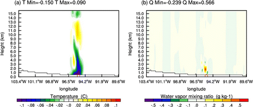
Figure 7. Analysis increment in the horizontal cross section for the experiment SOBS1, (a) around 850 hPa and (b) around 300 hPa. The red circle represents observation location for single observation tests.
Figure 8. Same as Fig. , but for the experiment SOBS2.
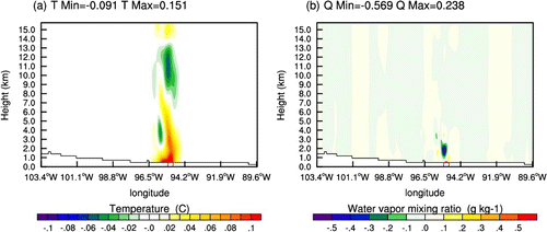
Figure 9. Same as Fig. , but for the experiment SOBS2.
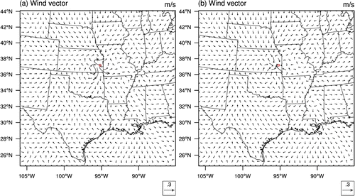
Figure 10. Same as Fig. , but for the experiment SOBS3, which observation location is at 38.5N, 95.13
W.
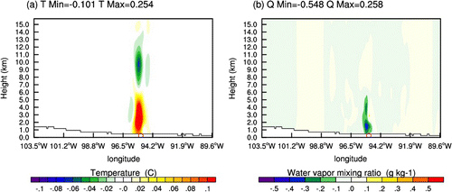
Figure 11. Same as Fig. , but for the experiment SOBS3, which observation location is at 38.5N, 95.13
W.
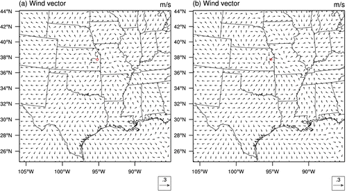
Figure 12. 1-h accumulated precipitation from WRF non-linear model initialized from the first outer loop analysis valid at 0100 UTC 9 June 2010.
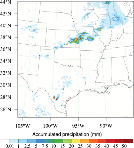
Figure 13. Wind analysis overlay with analysis increment of water vapour mixing ratio from (a) GTS, and (b) GTS+RAIN at 850 hPa at 0000 UTC 9 June.
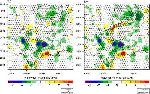
Figure 14. Wind analysis overlay with analysis increment of temperature from (a) GTS and (b) GTS+RAIN at 850 hPa at 0000 UTC 9 June.
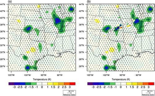
Figure 15. NCEP Stage IV observations and 1–3 hourly accumulated precipitation forecasts from 2 experiments initialized at 0000 UTC 9 June 2010. The top row: Stage IV observation; the second row: GTS; the third row: GTS+RAIN. In the bottom two rows, the locations of observed features are outlined in blue and the features predicted by the GTS and GTS+RAIN are overlaid and colour filled for precipitation greater than 5 mm.
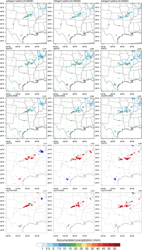
Figure 16. Same as Fig. but for forecasts of 4–6 h hourly accumulated precipitation (mm) initialized at 0000 UTC 9 June 2010.
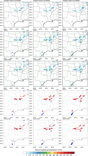
Figure 17. Aggregate FSS of hourly-accumulated precipitation over one-week for GTS and GTS+RAIN using 20 km radius of influence. The vertical bars represent the confidence intervals at the 95% confidence level using bootstrap resampling method with 10,000 resamples. (a) 1 mm threshold, (b) 5 mm threshold and (c) 10 mm threshold.
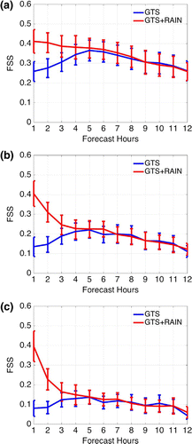
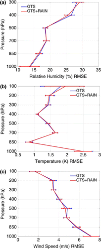
Figure 18. Vertical profiles of the RMSEs aggregated over 1-week results for GTS and GTS+RAIN at 6 h forecast. The horizontal bars represent the confidence intervals at the 95% confidence level using bootstrap resampling method with 10,000 resamples. (a) relative humidity, (b) temperature and (c) wind speed.