
Figures & data
Table 1. EC-Earth simulations 1–17 and their abbreviations are presented together with information about atmosphere–ocean interaction, physical parameteriztion and horizontal and vertical atmospheric resolution. Horizontal resolution is given as triangular spectral horizontal truncation and grid spacing at the equator. Coupled simulations were used as three members for CMv2-l, two members for CMv3-l and five for CMv3-m. Note that the number of vertical layers differ with 62 levels for EC-Earth v2 and 91 for EC-Earth v3 simulations, apart from CMv3-l with 62 levels.
Figure 1. Seasonal mean blocking frequency [] of the three reanalyses ERA-I (solid black), ERA-20C (dashed red) and JRA-55 (dot-dashed blue) as a function of longitude. The bootstrapped 95% confidence interval frequency range of ERA-I blocking (black dotted area) indicates typical inter-annual variability. Thinner dashed lines show blocking frequency from ERA-20C calculated for 26-season periods 1900–1926, 1925–1951 and 1952–1978.
![Figure 1. Seasonal mean blocking frequency [] of the three reanalyses ERA-I (solid black), ERA-20C (dashed red) and JRA-55 (dot-dashed blue) as a function of longitude. The bootstrapped 95% confidence interval frequency range of ERA-I blocking (black dotted area) indicates typical inter-annual variability. Thinner dashed lines show blocking frequency from ERA-20C calculated for 26-season periods 1900–1926, 1925–1951 and 1952–1978.](/cms/asset/e42ea41c-3496-4b60-825a-ff3f108167e9/zela_a_1406252_f0001_oc.gif)
Figure 2. Daily central blocking latitude [N] as function of longitude and month of year over the area of interest for reanalyses ERA-I (a) and ERA-20C (d). EC-Earth simulations as difference to ERA-I (model minus ERA-I in [
lat], b-m and colourbar below b). Contours are spaced in steps of
lat, full red lines represent positive/northward and dashed blue negative/southward differences. CM maps are based on single members and representative for all realizations. March 1st is marked with a dashed horizontal line.
![Figure 2. Daily central blocking latitude [N] as function of longitude and month of year over the area of interest for reanalyses ERA-I (a) and ERA-20C (d). EC-Earth simulations as difference to ERA-I (model minus ERA-I in [ lat], b-m and colourbar below b). Contours are spaced in steps of lat, full red lines represent positive/northward and dashed blue negative/southward differences. CM maps are based on single members and representative for all realizations. March 1st is marked with a dashed horizontal line.](/cms/asset/facfbe44-e1b1-44c0-8269-43250ab5915f/zela_a_1406252_f0002_oc.gif)
Figure 3. Taylor diagrams showing properties of the seasonal-mean climatological blocking frequency between W and
E. The standard deviation from simulations is normalized by the standard deviation of the seasonal mean anomalies from ERA-I (radial distances to the origin, blue-dashed isolines). The diagram also shows the correlation coefficient between the climatological blocking distribution of each individual data-set (reanalysis or model simulation) and ERA-I (the angle from the abscissa as indicated on the outermost circle, black-dashed isolines). The radial distance between ERA-I at (1,1) and the respective data-set is the RMS error (light grey isolines). Diagrams for winter (a) and spring (b) contain data of reanalyses (black), EC-Earth v2 (red) and v3 (blue: CMv3-m and AMv3, yellow: CMv3-l) as summarized in Table . Description of atmosphere-only simulations is given in panel b. AM colours correspond to the CM labels: red (blue) shows AMv2 (AMv3) results.
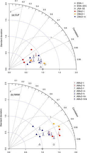
Figure 4. ERA-I blocking frequency [] and differences [percentage points] of AM and CM simulations to ERA-Interim (EC-Earth minus ERA-I) for winter (full lines) and spring (dashed). Statistically significant differences of models relative to ERA-I based on a moving block bootstrap are coloured green and blue for winter and spring, respectively.
![Figure 4. ERA-I blocking frequency [] and differences [percentage points] of AM and CM simulations to ERA-Interim (EC-Earth minus ERA-I) for winter (full lines) and spring (dashed). Statistically significant differences of models relative to ERA-I based on a moving block bootstrap are coloured green and blue for winter and spring, respectively.](/cms/asset/f2d8982e-019e-4157-93f1-ea11dacdfe90/zela_a_1406252_f0004_oc.gif)
Figure 5. Differences (row-column, [percentage points]) between AM simulations based on different physical parameterization (EC-Earth v2/v3) and resolution (l/h). The line is coloured where the difference between two model setups is statistically significant. Green (blue)-coloured regions indicate that the row (column) model is closer to ERA-I. The respective models are marked in the same colour.
![Figure 5. Differences (row-column, [percentage points]) between AM simulations based on different physical parameterization (EC-Earth v2/v3) and resolution (l/h). The line is coloured where the difference between two model setups is statistically significant. Green (blue)-coloured regions indicate that the row (column) model is closer to ERA-I. The respective models are marked in the same colour.](/cms/asset/c708546b-e799-4bf1-a9c7-0b32a0d07055/zela_a_1406252_f0005_oc.gif)
Figure 6. As Fig. but for CM simulations. The thick-dashed black line indicates bootstrapped frequency and statistical analysis combining all CM members of same setup into one timeseries. Colouring indicates statistical significance as for individual members.
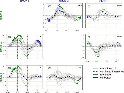
Figure 7. Mean state of geopotential height [m] at 500 hPa in ERA-I (a) and as difference of EC-Earth to ERA-I (EC-Earth minus ERA-I in [m], b-i and colourbar below b) are shown in coloured contour fields. CM simulations are included with one representative member. All results for winter.
![Figure 7. Mean state of geopotential height [m] at 500 hPa in ERA-I (a) and as difference of EC-Earth to ERA-I (EC-Earth minus ERA-I in [m], b-i and colourbar below b) are shown in coloured contour fields. CM simulations are included with one representative member. All results for winter.](/cms/asset/fcccfd23-b613-4555-a5ec-9de4994bba01/zela_a_1406252_f0007_oc.gif)
Figure 8. As Fig. but for spring.
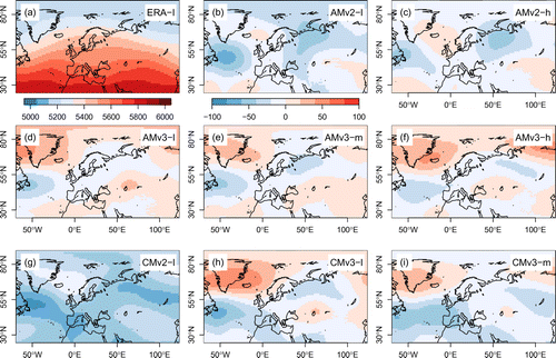
Figure 9. Composites of geopotential height [m] winter blocking signature for (a) ERA-I and (b–i) absolute value differences of EC-Earth to ERA-I (EC-Earth minus ERA-I, colourbar below panel b) in coloured contour fields. Only statistically significant values from a bootstrap with 1000 resamples are shown. Contour lines show the blocking signature in geopotential height of ERA-I in steps of 50 m from 75 m with bold lines representing positive values and dashed lines depicting negative anomalies. CM simulations are included with one representative member.
![Figure 9. Composites of geopotential height [m] winter blocking signature for (a) ERA-I and (b–i) absolute value differences of EC-Earth to ERA-I (EC-Earth minus ERA-I, colourbar below panel b) in coloured contour fields. Only statistically significant values from a bootstrap with 1000 resamples are shown. Contour lines show the blocking signature in geopotential height of ERA-I in steps of 50 m from 75 m with bold lines representing positive values and dashed lines depicting negative anomalies. CM simulations are included with one representative member.](/cms/asset/476d8162-7424-4180-a73a-398fd6800019/zela_a_1406252_f0009_oc.gif)