Figures & data
Fig. 1. The shipping route of the VOS ships in South-East Asia: southbound route (Japan to Indonesia; green); northbound Asia and Borneo routes (Indonesia–Japan; orange and red). The area surrounded by the dashed square around Peninsula Malaysia was divided into two regions for the analysis, as shown in the inset (Malay area, blue; Malacca and Singapore area, magenta).
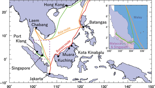
Fig. 2. CO distribution around Malay Peninsula observed by the two VOS ships during the period from mid-June to mid-August 2013. The CO distribution is shown separately for each voyage (TF1, M/V Trans Future 1; FW, M/V Fujitrans World), and the dry mole fractions of CO are plotted along the shipping route. The CO enhancement episodes are numbered individually, and CO data during the episodes are represented by black-rimmed dots, with the episode duration presented below the episode number.
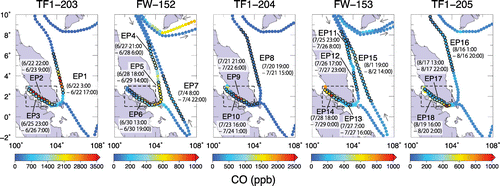
Fig. 3. Temporal variation of the 1-h-mean CO dry mole fractions (upper panels) along with the monthly CO anomaly for June, July and August from 2008 to 2013 (lower panels) observed in the Malay area and the Malacca and Singapore area. The coloured dashed lines in the lower panels represent linear interpolations to account for missing data.

Fig. 4. Distribution of monthly fire radiative power (FRP) intensity with a spatial resolution of 0.25° × 0.25° over Sumatra from May to September 2013. The area over Sumatra surrounded by the dashed square line indicates the study area used for detailed analysis in this study.
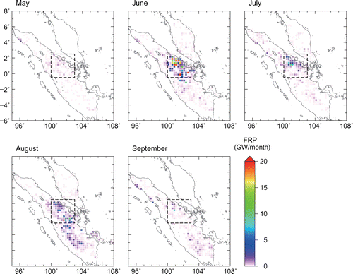
Fig. 5. Time series for the daily FRP value for Sumatra (black line) and the study area (red line) in June, July and August 2013. The vertical dashed lines indicate CO peak times for each CO enhancement episode (shown in Figure 2), using the following colour codes: blue for the Trans Future 1, green for the Fujitrans World. The colour codes for the episode numbers indicate the estimated transport time for the air masses from the study area to the VOS ship (cyan, up to 1 day; magenta, 2 days; orange, 4 days) based on the backward trajectory analysis; black codes indicate no air mass history that pass directly over the study area. Note that the daily FRP values were derived from discrete MODIS FRP observation.
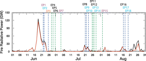
Fig. 6. Monthly column data for the distribution of CO from AIRS data for South-East Asia in June, July and August 2013.
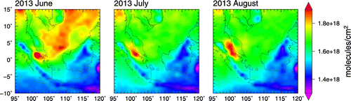
Fig. 7. Daily CO column distribution from the AIRS data for South-East Asia from 17 to 22 June 2013. The ship’s route and daily positions are indicated by dashed lines and thick black lines, respectively.
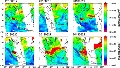
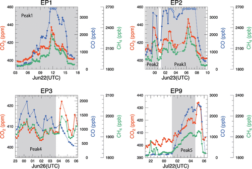
Fig. 8. Temporal variations of the 10-min mean CO2, CO and CH4 during the four selected CO enhancement episodes (EP1, EP2, EP3 and EP9). The variations of these gases during the shaded periods were associated with peatland fire emission from the study area, which was identified based on the CO2-normarized enhancement ratio for CO.