Figures & data
Figure 1. (a, b) Observed and (c, d) simulated radar composite reflectivity (shaded; units: dBZ). The times for (a) and (c) are 1902 and 1900 UTC 18 August 2010, respectively. The times for (b) and (d) are 0102 and 0100 UTC 19 August 2010, respectively. Distributions of 6-h accumulated precipitation (shaded; units: mm) in the (28–33°N, 100–106°E) region of the 3-km resolution domain: (e) 1800 UTC 18 August to 0000 UTC 19 August 2010; (f) 0000 to 0600 UTC 19 August 2010. The red ‘ + ’ represents Chengdu radar station. Black contours represent the distance from Chengdu radar station.
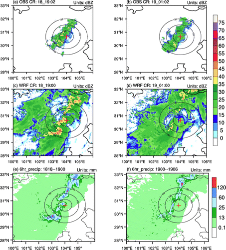
Table 1. Grid number and mean six-hourly accumulated precipitation (P6) of each precipitation bin in the (28–33°N, 100–106°E) region of the 3-km resolution domain.
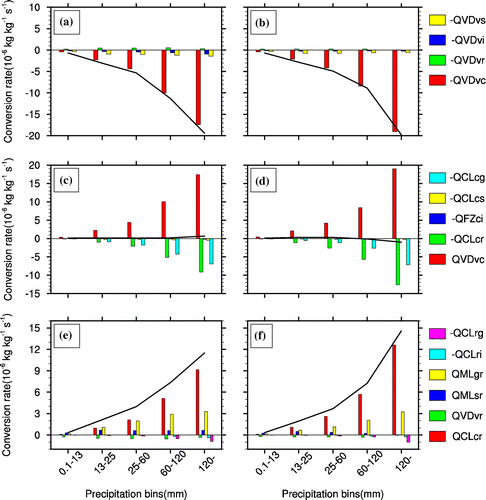
Figure 2. (a, b) Variations of water species’ mixing ratios, (c, d) number concentrations, and (e, f) mean-mass diameters with increasing precipitation intensity during 1800 UTC 18 August to 0000 UTC 19 August 2010 (left column) and 0000 to 0600 UTC 19 August 2010 (right column). Their units are shown in the figures. In (a) and (b), blue curves represent water vapor mixing ratios, red curves represent liquid hydrometeor mixing ratios, and black curves represent solid hydrometeor mixing ratios.
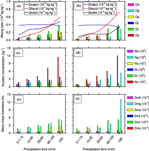
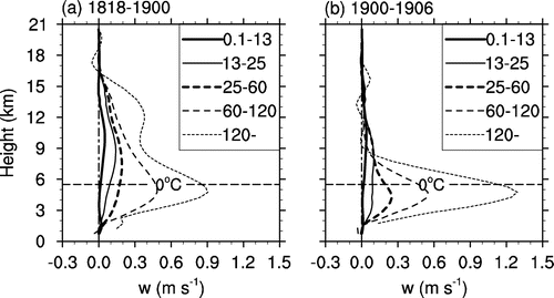
Figure 3. Vertical velocity profiles in various precipitation bins (units: m s−1). The horizontal dashed lines represent averaged zero-layer height of all precipitation grids: (a) 1800 UTC 18 August to 0000 UTC 19 August 2010; (b) 0000 UTC to 0600 UTC 19 August 2010.