

ABSTRACT
We present a new approach for accessing and visualizing point-based data in CAD applications. Instead of developing a traditional database around spatial data structures, our approach augments a data indexing engine to enable quick access to data. The primary advantage of an indexing engine is flexibility. The approach enables both range queries for accessing data spatially and resolution queries to access data at appropriate spatial resolutions. Our approach is robust to very large datasets, naturally supporting remote visualization and near-real-time input data streams. We demonstrate our approach on 2 large datasets, one 45M points, the other 53M points.
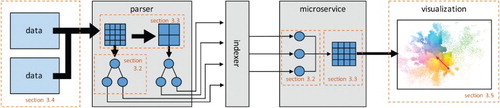
GRAPHICAL ABSTRACT
Acknowledgements
This work was supported by NSF DIBBs [ACI-1443046]. All opinions, findings, conclusions and recommendations expressed in this paper are those of the authors and do not necessarily reflect the National Science Foundation or the University of South Florida.
ORCID
Paul Rosen http://orcid.org/0000-0002-0873-9518
Les A. Piegl http://orcid.org/0000-0003-0629-8496