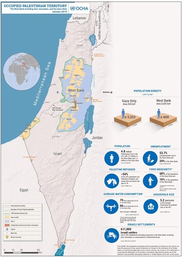
Figures & data
Figure 1. Map of the Occupied Palestinian Territory. Source: United Nations Office for the Coordination of Humanitarian Affairs – Occupied Palestinian Territory. The original figure, which includes additional text boxes, is available at https://www.ochaopt.org/content/west-bank-including-east-jerusalem-and-gaza-strip-january-2019
![Figure 1. Map of the Occupied Palestinian Territory. Source: United Nations Office for the Coordination of Humanitarian Affairs – Occupied Palestinian Territory. The original figure, which includes additional text boxes, is available at https://www.ochaopt.org/content/west-bank-including-east-jerusalem-and-gaza-strip-january-2019](/cms/asset/e303c46d-b955-4e89-82dd-335d0a1c3e3a/rgph_a_2171087_f0001_oc.jpg)