Figures & data
Figure 1. (a) Physiographic and geological setting of the North Garganic Adriatic sector (from CitationRidente & Trincardi, 2002). (b) Panorama of the islands from San Domino, from SW towards NE.
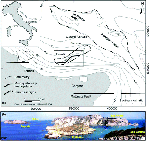
Figure 2. Bathymetry and orography of the Tremiti Islands and surrounding inner continental shelf.
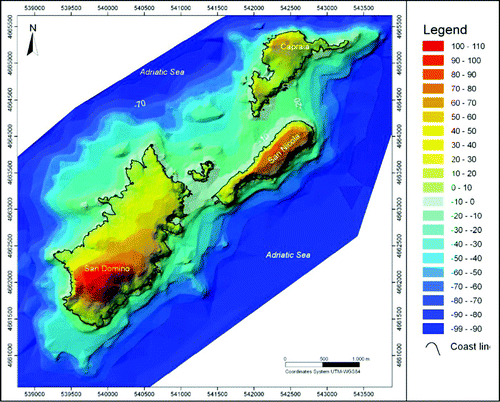
Figure 3. Methods for the creation of the Geomorphological map of the Tremiti Islands overlying: bathymetry (1:15,000) and orography (1:5,000) analysis (A), for the processing of the DTM of the archipelago (B), side scan sonar acquisition (C), geomorphological and Quaternary continental deposits surveys on both the islands and the inner continental shelf around them (D), for the creation of geomorphological map and schemes presented in this work (E).
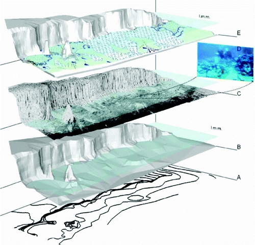
Figure 4. Quaternary continental deposits of the islands (the abbreviations refer to the morpho-lithostratigraphic scheme included in the map) (CitationMiccadei et al., 2011a). (a) San Domino, Cala degli Inglesi (Br – Breccia, paleosols, conglomerates and red loess unit and Cr – Calcretes unit), stratified breccia, formed of decimetric and centimetric clasts, in lightly cemented red-brown sandy matrix, lying on an erosion surface, within pre-existent depressed morphologies on Cenozoic carbonate bedrock. In the higher part calcrete outcrops are about 0.7–0.8 m thick; (b) San Domino, Cala delle Roselle (Br – Breccia, paleosols, conglomerates and red loess unit and Cr – Calcretes unit), stratified breccia with sub-angular centimetric clasts, laying on carbonate bedrock; (c) Capraia, Cala dei Turchi (Br – Breccia, paleosols, conglomerates and red loess unit and Cr – Calcretes unit), paleosols and calcretes outcrop, in contact with carbonate bedrock; (d) San Nicola (Br - Breccia, paleosols, conglomerates and red loess unit), outcrop of breccia, paleosols and conglomerates, stratified in about 0.25 m thick layers; in the lower left a close up of the deposits is included; (e) Cretaccio (CR – Calcretes unit), calcrete in angular discordance on carbonate bedrock, age is 121 ±21 kyr (U/Th dating; CitationMiccadei et al., 2011a); (f) San Domino, Cala delle Roselle (As – Aeolian sand unit), yellow aeolian sand, outcropping within a karst depression (an example of the fossiliferous content is shown in the picture, given by continental gastropods).
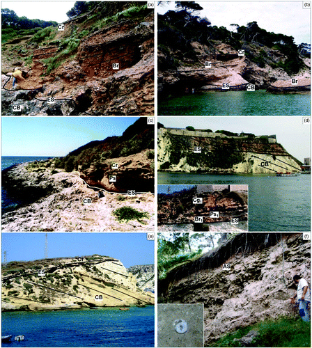
Figure 5. Main tectonic elements (CitationMiccadei et al., 2011a). (a) San Domino, I Pagliai, intensely tectonized area, characterized by NW-SE-oriented fault surfaces and cataclastic rocks; (b) Capraia, NW-SE-oriented faults; (c) Cretaccio, NE-SW-oriented faults, characterized by cataclastic rocks; (d) San Domino, Poggio Romito, visible E-W fault plane on carbonate bedrock (CB); (e) San Domino, Cala Tramontana, sigmoid structure indicating right strike-slip kinematic (plan view); (f) San Nicola, tectonic contact between Miocene limestone and marl, in the southeast sector of San Nicola.
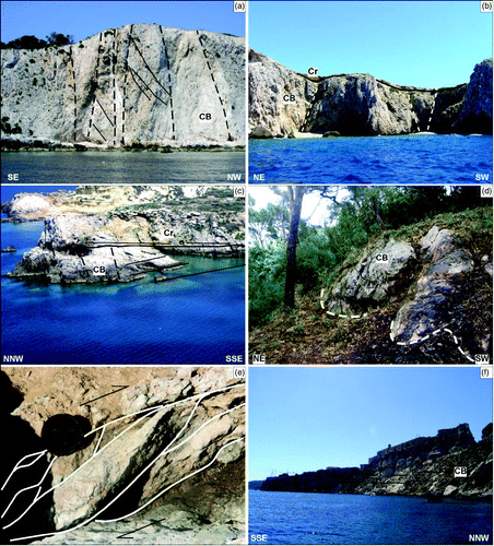
Figure 6. Submerged landforms surveyed by scuba-dive observations on the inner continental shelf (numbers indicate depth) (CitationMiccadei et al., 2011b); (a) Capraia island, incisions and erosional features, between sea-level and about 20 m b.s.l.; (b) San Domino island, detritic fan with centimetric and decimetric calcareous elements, sub-rounded, fossilized by algal fouling. Fan apex is located at about 8 m b.s.l.; the toe lies on the flat marine erosion surface at 20 m b.s.l.; (c) San Domino island, cave at sea-level extending down to 8 m b.s.l. (d) San Domino island, submerged cave at 10 m b.s.l.; (e) Capraia island, flat surface developed between 20 and 25 m b.s.l.; (f) Capraia island, inner margin of flat marine erosion surface observed by bathymetric analysis, at about 20 m b.s.l.; (g) Capraia island, shore platform at 8 m b.s.l.; (h) Metric sub-rounded coastal rockpools, at 8 m b.s.l.
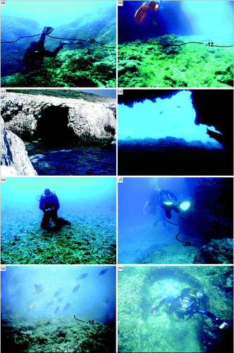
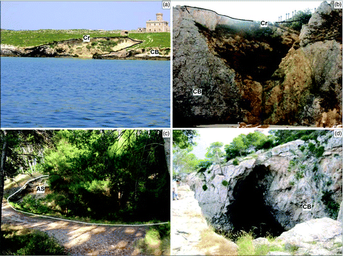
Figure 7. Geomorphological features on the islands (the abbreviations refer to the Morpho-lithostratigraphic scheme included in the map) (CitationMiccadei et al., 2011). (a) Capraia, partially submerged karst pothole, along the southern coast of the island; (b) San Domino, karst pothole in the north-east sector of the island, with calcretes on top; dashed line indicates a tectonic discontinuity, characterized by NW–SE fault planes and cataclastic rocks (; (c) San Domino, pothole at Cala delle Roselle, partially filled by aeolian sands (AS); (d) San Domino, karst cave at sea-level.