Figures & data
Table 1. Data derived from the landslide database, including dominant movement type and morphometric parameters of the 83 largest landslides. The identification numbers correspond to those labelled in the map. Landslide volume was calculated using an estimated average thickness on the basis of the type and geomorphic characteristics of the landslides, as well as the position of the basal sliding surface identified in some movements by means of geotechnical investigations. Total values refer to the 83 largest landslides included in the data-base.
Figure 1. (A) Landslide n. 31. Slate flows partially mantled by andesite boulders derived from the upper free-face scarp and subsequently transported downslope by the displacement of the underlying slates. Arrow points to an infilled lacustrine basin generated when the landslides blocked the Gállego River. (B) Dissected lacustrine terraces upstream of landslides 21 and 67.
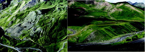
Figure 2. Deep-seated earthflows developed in Devonian slates. (A) Landslide n. 1 in the Lanuza Reservoir. The complex landslide is a slate flow that grades into a translational movement in the upper part. The fresh secondary failure at the flank of the landslide (shear zone) causes repeated damage on the A-136 road. (B) Earthflow n. 27 in the Culivillas Creek, largely reshaped due to the construction of ski tracks.
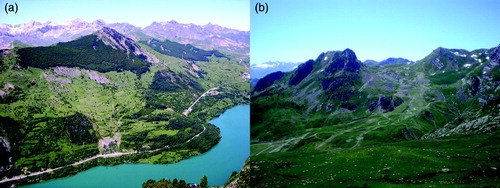
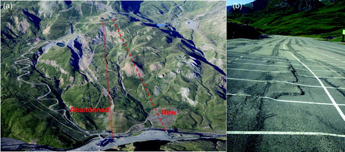
Figure 3. (A) Oblique aerial view of the active landslide n. 21. Red lines indicate the traces of the abandoned and new ski lifts. (B) Deformed pavement in a parking lot whose construction involved excavation at the toe of landslides n. 49 and n. 50.