Figures & data
Figure 1. Structural sketch map (A) of the northwestern Italy (modified from Bigi, Cosentino, Parotto, Sartori, & Scandone, Citation1983; Codegone et al., Citation2012; Mosca et al., Citation2010). (B) Location of .
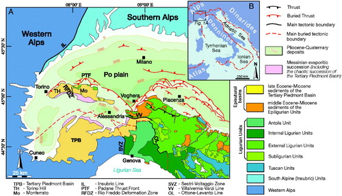
Figure 2. Stratigraphic columns of the External Ligurian Units, Epiligurian Units and Tertiary Piedmont Basin succession in Western Monferrato and Northern Apennines. Modified after Marroni et al. (Citation2010) and Codegone et al. (Citation2012).
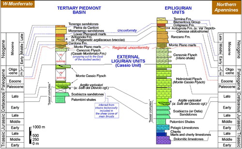
Figure 3. (A) Highly disrupted block-in-matrix fabric of the Argille varicolori characterized by intense fragmentation of the originally coherent succession (NE of Moglietto); (B) Polished hand sample of the matrix of the Argille varicolori of showing a layer-parallel extensional fabric characterized by pinch-and-swell structures and boudinage of the shaly layers; (C) Detail of the ‘Salti del Diavolo’ conglomerates (SE of Novarese); (D) Alternating calcareous turbidite and gray marl and clay of the Monte Cassio Flysch (NNE of Torrione); (E) Calcareous marl alternating with (F) light brown-yellowish hybrid turbiditic calcarenite of the Monte Cassio Flysch (NE of Moglietto).
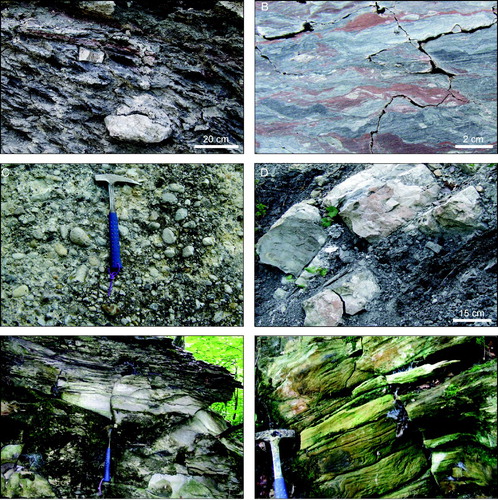
Figure 4. (A) Typical aspect of the gray calcareous hemipelagic Monte Piano marls (South of C. Valentino); (B) Alternating coarse-grained yellowish sandstone and burrowed gray-greenish mudstone of the Cardona Formation (ENE of C. Micheli); (C) Alternating yellowish sandstone and silty marl of the Antognola Formation (West of Piazzo); (D) Alternating brown-reddish silicified marl and silty marl of the Lower Pteropodi marls (West of Valletta); (E) Highly disordered block-in-matrix fabric of the Polygenetic argillaceous breccias showing differently shaped blocks of limestone, sandstone, marl and siltstone that float with random distribution in a brecciated shaly matrix (NW of Gerbole). (F) Polished surface of a hand sample of the Polygenetic argillaceous breccias showing the isotropic texture of the matrix (about 1 km to the NE of Moglietto).
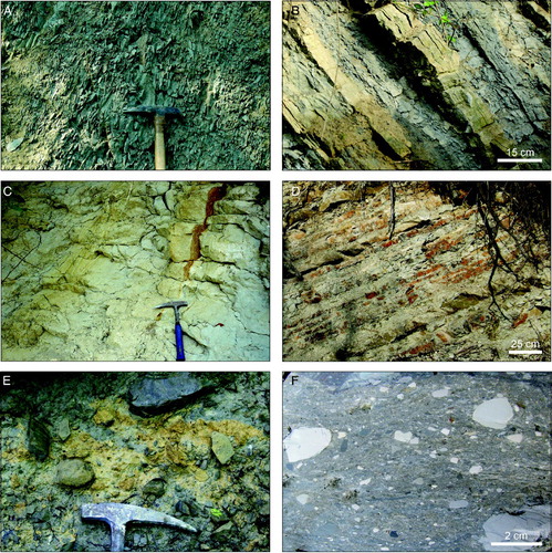
Figure 5. (A) Alternating yellowish microconglomerate and gray marl of the Moransengo sandsones (SE of C. Micela); (B) Whitish calcareous marls of the Pietra da Cantoni (South of Scalaro); (C) Light gray to whitish hybrid arenite and sandstone of the Tonengo sandstones (East of Pareglio).
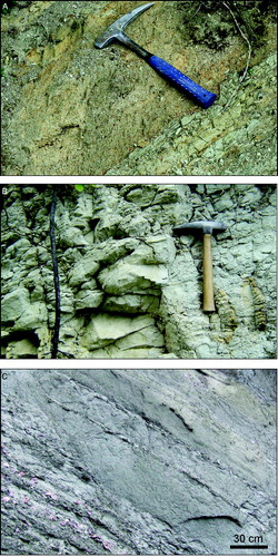
Figure 6. (A) Polished hand sample of Argille varicolori showing asymmetric boudinage related to extensional shearing and in situ disruption of alternating layers of sandstone (white) and shale (red and gray) (East of Gerbole). White lines indicate R-shears; (B) Polished surface of a hand sample showing R-shears (see dashed lines) transecting the varicolored shaly layers of the Argille varicolori (North of Piazzo); (C) Decimeters wide, intralayered flattened fold in the Argille varicolori (ENE of Gerbole); (D) Mesoscale left-lateral transtensive fault showing a ‘tulip type’ flower structure in the Monte Piano marls (South of Piazzo); (E) Plan view of a mesoscale left-lateral transtensive fault in the Monte Piano marls (South of Piazzo). The photograph on the left is schematically redrawn on the right of the figure. Mesoscale data of the fault are also shown in the structural diagram (Schmidt net, lower hemisphere); (F) ‘Structurally ordered’ block-in-matrix fabric within the Argille varicolori tectonic mélange close to the main thrust (SW of la Pietra). The fabric is related to NE-verging reverse shear (red lines) and it is characterized by elongated extra-formational blocks embedded in a matrix pervasively affected by scaly fabric and S-C features; (G) Polished surface of a hand sample of the Argille varicolori tectonic mélange showing the reverse shear surfaces and related R-shear, and a pervasive scaly fabric (about 1 km to the NE of Moglietto).
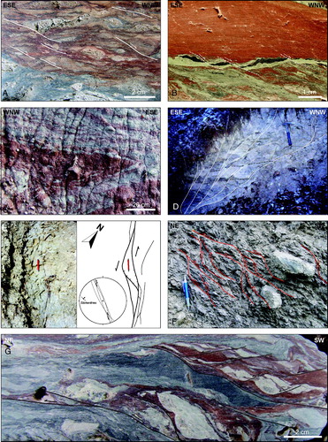
Figure 7. Mesoscale data (Schmidt net, lower hemisphere) of the extensional scaly fabric (A) and fold axes (B) of the Argille varicolori broken formation, and the scaly fabric (C) of the Argille varicolori tectonic mélange.
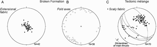
Figure 8. Simplified geological-structural map of the investigated area showing the crosscutting relationships between different faulting stages (indicated with different colors) and stratigraphic unconformities (see text for a complete explanation). These relationships allow us to define four tectonic stages as summarized in the time column in the right part of the figure.
