Figures & data
Figure 1. Plate reconstruction for the western Mediterranean area, after CitationStampfli et al. (1998), CitationStampfli, Borel, Cavazza, Mosar, & Ziegler (2001), from CitationCarmignani, Conti, Cornamusini, and Meccheri (2004) modified. Slightly different plate reconstruction is proposed also by CitationHandy, Schmid, Bousquet, Kissling, and Bernoulli (2010) and CitationTurco, Macchiavelli, Mazzoli, Schettino, and Pierantoni (2012). A-A′ in (a) is the trace of reconstruction in .
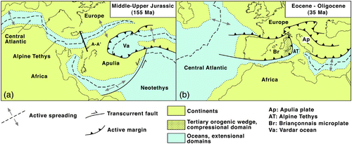
Figure 2. Main geodynamic events in the Northern Apennines; after Carmignani et al. (Citation2001), modified.
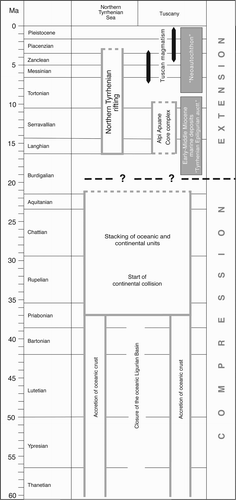
Figure 3. Palinspastic reconstruction of the western continental margin of Apulia, Tethys ocean and adjoining European margin during the late Jurassic (after CitationBernoulli, 2001; CitationHoogerdujin Strating, 1990; CitationMarroni, Molli, Montanini, & Tribuzio, 1998; CitationPeybernès, Durand-Delga, & Cugny, 2001; CitationRossi, Cocherie, Lahondère, & Fanning, 2002, modified). SW and NE are referred to present day coordinates; this reconstruction is approximately indicated as A-A′ section in a.
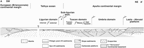
Figure 4. Schematic cross section of the Northern Apennines in the Aquitanian time.
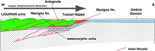
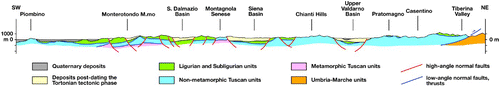
Figure 5. Geological cross section across Tuscany. See trace location in the Tectonic Map at the bottom of the Geological Map (see Main Map).