Figures & data
Figure 1. Location of the Tatra Mountains on a map of Quaternary glaciation limits in Central Europe. The LGM ice limit and mountain glaciers are indicated by a darker blue area. The most extensive ice limit during the Quaternary is indicated by a lighter blue area. Ice limits based on Ehlers, Gibbard, and Hughes (Citation2011, supplementary digital data, modified in the Western Carpathians); base topography – ETOPO (2009, http://www.ngdc.noaa.gov); sea surface lowered to −120 m.
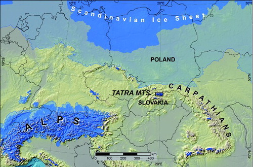
Figure 2. Schematic geological map and geographic subdivision of the Tatra Mountains. Dashed-dotted line indicates national border; dashed lines mark geographic boundaries dividing the Tatra Mountains into three geographic regions; glacial lakes are depicted in blue.
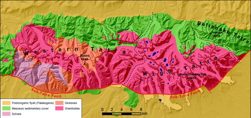
Figure 3. Spatial extent of previous geological and geomorphological maps, which contain information on glacial landforms and deposits, and the extent of remote sensing data utilized in this study: IKONOS (2004) – Ikonos satellite multispectral image taken in August of 2004, 1 m resolution (source: Tatra National Park, Poland); LiDAR (2013) – 1 m resolution DEM from laser scanning (source: CODGIK, Poland); Geological Map 10 k – Geological Map of the Polish Tatra Mountains at a scale of 1:10 000, 14 sheets (1958–1978), S. Sokołowski & K. Guzik (Eds), Wydawnictwa Geologiczne, Warszawa.
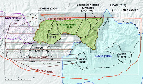
Figure 4. A. Relief characteristics of LGM and most extensive (pre-LGM) glacial deposits using an example from the mouth of Białka Valley. The Rusinowa Polana meadow is a classical site of the most extensive till cover in the Tatras; I-III – moraines related to the LGM. B. The difference in relief roughness between pre-LGM and LGM till cover enhanced by the topographic position index (Jenness, Citation2006) derived from LiDAR DEM; blue areas stand above and red below a mean elevation calculated in 25 m radius.
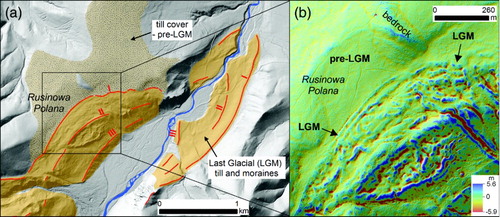
Figure 5. Studená Valley morainic amphitheater. A. Schematic map by Lukniš (Citation1968 – a part of the map, which supplements a detailed geomorphological map at a scale of 1:50 000). The map shows complex chronology of repeated glacial advances during the last glaciation (Würm) stadial oscillations: A (Rakytovec), B (Stosy), C (Tatranská Lomnica), D (Veza); penultimate glaciation Rs (Riss); and oldest glaciation Mn (Mindel). B. Perspective view of the Studená Valley morainic amphitheater with highlighted geometry of the latero-frontal dump moraine complex formed by a debris-covered glacier (Google Earth ®, vertical scale two times exaggerated; image: Digital Globe): 1 – latero-frontal dump moraines, 2 – secondary morainic lobes, 3 – hummocky moraine, 4 – abandoned outwash channels on moraine slope.
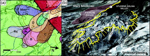
Figure 6. Geomorphological evidence of glaciation found on the northern face of Mount Giewont; an example of glaciation evidence not previously reported in geomorphological and paleoglaciological maps: A. Slope map (derived from LiDAR DEM) showing flat-floored valley-heads and semicircular oversteepened backwalls engraved on the foot of structural rock wall of Mount Giewont; moraine crests are depicted as red dashed lines; B. Cross section profile (a-b) of the right terminal moraine in the Mała Dolinka valley. The location of cross-section a-b is shown in the panel (a); C. Crest line (white dashed line) and distal slope of the right lateral moraine of the Mała Dolinka glacier; D. Sub-angular to sub-rounded allochtonous limestone boulders on the surface of moraine relics (fresh excavation)
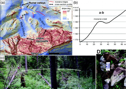
Figure 7. Ice-marginal landforms on the southern slope of the High Tatra Mountains: A. typical high moraine ramps in Velická and Slavkovská Valley; B. Relict rock glaciers associated with LGM moraines: a – steep frontal slope of the relict rock glacier lobe associated with the left lateral moraine of the Batižovská Valley glacier; b – relict rock glacier tongue (c.f. Lukniš, Citation1973) associated with the latero-frontal moraine at the outlet of the Grerlachovský kotol cirque (c). This moraine belongs to the LGM moraine system and the top (left) reaches the extraordinarily high elevation of 2120 m in entire Tatra Mountains.
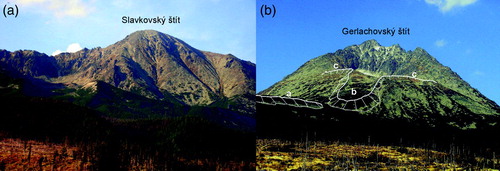
Figure 8. Trimlines and cirque backwall morphology as an ice-elevation record in the upper parts of glaciated valleys: A. Slope map (derived from LiDAR DEM) of a part of Roztoka Valley and hanging tributary cirque (Buczynowa Valley). The map shows a typical trimline in a glacial trough, which is discernible as a steeper (several tens of meters high) rock wall (trimline zone) standing between a gentler sloping rock bench below and rugged terrain above (profile a-b). The trimline gradually transits into the oversteepened lower part of the cirque backwall (profile c-d) in the Buczynowa Valley cirque. In this study, the maximum vertical extent of LGM glaciers is assumed to be found at the upper edge of trimline zones in troughs and the upper edge of backwall oversteepings in cirques, as shown in profiles a-b and c-d; B. Cirque backwall engraved in gentler sloping terrain. Note blockfield on slope above the cirque edge (Kobyla Valley cirque, which is the right-hand tributary of Koprova Valley, located south of Gładki Wierch Mountain). This type of cirque is typical of the Western Tatras; C. Oversteepened lower part of cirque backwall typical of High Tatras – example of Batižovská Valley cirque. Note rugged rocky terrain above the oversteepened rock wall. Arrows in photographs B and C indicate the maximum vertical position of glacial influence on terrain.
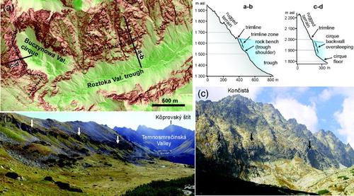
Figure 9. Periglacial blockfields: A. Granite blockfield on the southern slope of Kriváň Mountain (High Tatras), which developed through in situ weathering (autochthonous blockfied, Ballantyne, Citation2010); B. Granite blockfield on the slope of Jarząbczy Wierch Mountain (Western Tatras), partially mobilized (blockstreams, solifluction lobes; allochthonous blockfield).