Figures & data
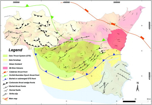
Figure 1. Geological-structural map of Sicily (modified after CitationBigi et al., 1992; CitationCatalano, 2013; CitationCatalano, Agate et al., 2013; CitationCatalano, Valenti et al., 2013; CitationValenti, 2011 and from geological maps compiled in the frame of the Vigor project (CitationVIGOR website, 2013)). The inset A) shows the schematic structural map of the central Mediterranean (modified after CitationCatalano, Agate et al., 2000; CitationCatalano, Valenti et al., 2013; Ionian detailed data from CitationValenti, 2010; see also the inset in the Main Map. The inset B) illustrates the main tectonic elements characterizing the collisional complex of Sicily: (1) the undeformed Pelagian-Iblean foreland, (2) the present-day foredeep; (3) the orogenic wedge: the Calabrian-Peloritani units(3a), the main FTB (3b-c) southwards buried by the Gela Thrust System (3d) in its turn partially covered by the Gela foredeep. BUPP: boundary of the Undeformed Pelagian Platform (after CitationCatalano, Valenti et al., 2013).
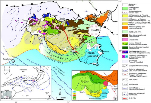
Figure 2. Stratigraphy and original facies domains of the Mesozoic-Cenozoic rock bodies deposited prior to the onset of Miocene deformation. Miocene-Pleistocene deformed foreland and wedge top basin deposits, progressively involved in the deformation, follow upwards. The main tectono-stratigraphic events in Sicily as well as in the central Mediterranean, providing an overview of the many supra-regional episodes that affected the tectonic evolution of Sicily are reported (modified after CitationCatalano, 2013, inspired to CitationCatalano & D'Argenio, 1982).
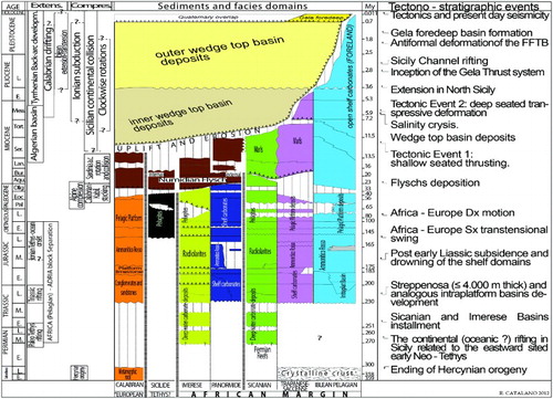
Figure 3. Geological cross-section resulting from the interpretation of the seismic stack section of the SI.RI.PRO. crustal profile and its south-eastern commercial multichannel seismic extension (after CitationCatalano, Valenti et al., 2013). (A) Location map of the SI.RI.PRO crustal profile. The interpreted top of the carbonate regional geothermal reservoir is reported as a dotted yellow line.
Figure 4. Exposed mesozoic carbonates constituting the regional geothermal reservoir, (a) Sparagio Mt., (b), Montagna Grande, (c) and (d) Sclafani Bagni, (e) Balatelle Quarry. The location of the photographs is also given.
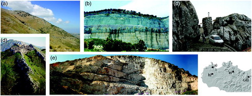
Figure 5. Central and Western Sicily. Areas in which the top of the geothermal reservoir matches with the topography, the thermal springs are also sited. In eastern Sicily the reservoir is mostly buried.
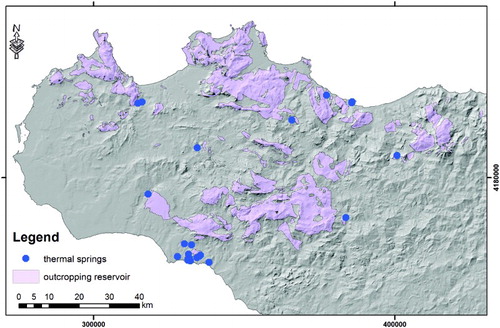
Figure 6. Sicily base map showing the location of wells and the traces of geological cross sections and seismic profiles utilized for the reconstruction of the top of the geothermal reservoir surface.
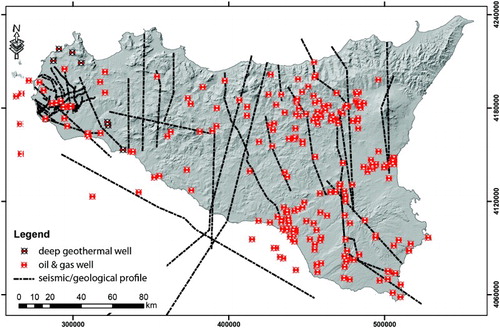
Figure 7. Exemplificative view of the integration between different data (borehole stratigraphy, seismic profiles, and geological cross sections) during the 3D modeling, the purple surface represents the top reservoir surface during a step of the modeling approach.
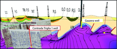
Figure 8. Sketch illustrating the overly of the main regional structures on the map of the reservoir top (based on CitationBigi et al., 1992; CitationCatalano, 2013; CitationCatalano, Agate et al., 2013; CitationCatalano, Valenti et al., 2013).