Figures & data
Figure 1. Location of the Hérens valley. The corners and white dots indicate the location of the photos; the numbers refer to the figure numbers. © [Swisstopo]. Reproduced with the permission of swisstopo (BA13064).
![Figure 1. Location of the Hérens valley. The corners and white dots indicate the location of the photos; the numbers refer to the figure numbers. © [Swisstopo]. Reproduced with the permission of swisstopo (BA13064).](/cms/asset/079400e9-1afd-4bb8-8a59-1569614fdc63/tjom_a_999135_f0001_b.gif)
Figure 2. Geological sketch of the Hérens valley.
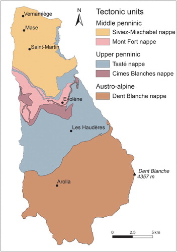
Figure 3. (a) Typical landscape at the north-east of St-Martin, with relict rock glaciers at the foot of quartzitic talus slopes. Processes are generally low or no longer active. (b) The smooth slopes dominating Evolène, made with calcschists of the Tsaté nappe.
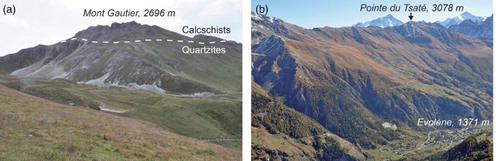
Figure 4. The large rock faces dominating the glacial and periglacial landscapes in the Dent Blanche nappe sector (the southern part of the Hérens valley). (a) Grand Cornier and Dent Blanche, with the Bricola and Dent Blanche glaciers (Ferpècle catchment). (b) Pigne d'Arolla and Tsijiore Nouve glacier, above Arolla. (c) The Tsarmine sector, with its debris-covered glacier and the large associated Holocene moraine deposits and the active Tsarmine rock glacier (Arolla catchment). (d) The debris-covered La Tsa glacier and its thick Holocene moraine deposits (east of Arolla).
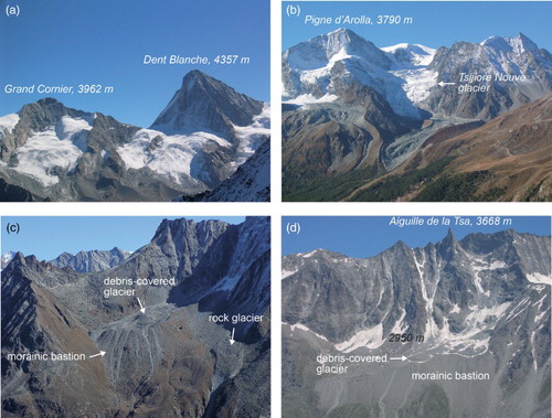
Figure 5. (a) Mont Miné glacier and glacier forefield (Ferpècle valley; photo 2004). The arrow indicates the location of the Nye channels depicted in (b).
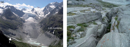
Figure 6. (a) Euseigne Pyramids and (b) La Luette morainic complex.
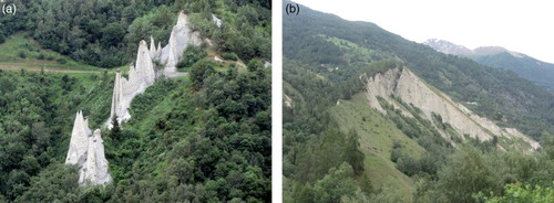
Figure 7. Left lateral moraines of the Tsijiore Nouve glacier. (a) Lateglacial (Egesen stadial) and LIA moraines. (b) Solifluction on the LIA moraine.
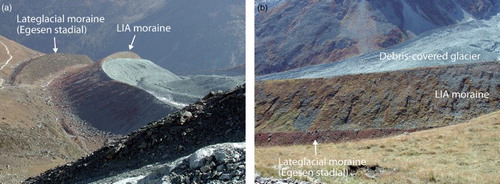
Figure 8. Dislocated DSGSDs on the right side of the Arolla catchment. The arrows show the upper limit of the landslides. On (a) the fresh scarps indicate the high activity of the landslide, amplified by the lateral erosion by debris flows.
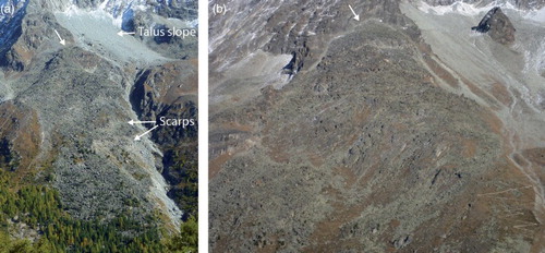
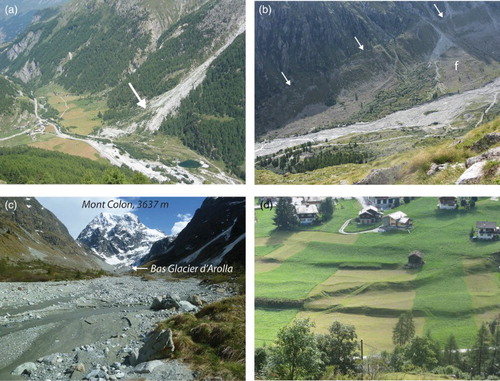
Figure 9. Gravitational and periglacial landforms in the Hérens valley. (a) Talus slopes and rock glaciers in the Fontanesses catchment (Arolla). a, active rock glacier, i, inactive rock glaciers, r, relict rock glaciers. (b) The large A-Vieille relict rock glacier, made of calcschists of the Sasseneire. (c) La Roussette active rock glacier (east of Arolla). (d) The large inactive rock glacier of Liapey d'Enfer.
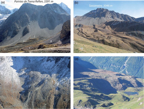
Figure 10. Fluvial landforms in the Hérens valley. (a) The torrential fan at Satarma (Arolla catchment). (b) The braided course of the Borgne d'Arolla River, in the proglacial margin of the Bas Glacier d'Arolla. The arrows show the LIA right lateral moraine. f, torrential fan. (c) Closer view of the Borgne d'Arolla River. (d) Alluvial terraces in Les Haudères.