
Figures & data
Figure 1. Overview map of Ligurian landslides from IFFI Project database (CitationISPRA, 2008). Black bold line indicates the Ligurian catchment of the Upper Scrivia valley.
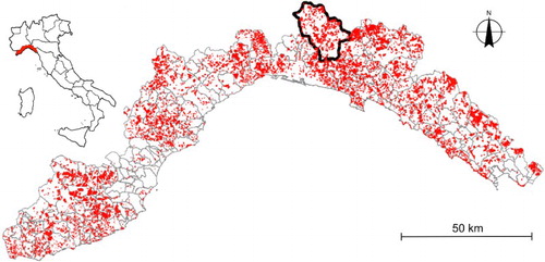
Figure 2. Ligurian catchment of the Scrivia Stream (Digital Terrain Model 5 m resolution) and map of slope gradient (right).
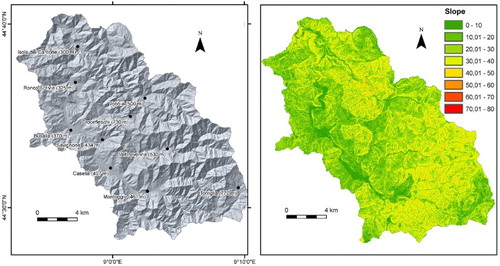
Figure 3. Geological-tectonic sketch map (left). Legend: (1) VU: Voltri Units; (2) SV: Sestri-Voltaggio zone; (3) VPU: Valpolcevera Flysch Units; (4) AUL: Antola unit, marly-limestone flysch; (5) AUS: Antola unit, Montoggio Shales; (6) GU: Gottero unit; (7) OL: Oligo-Miocene formations and (8) Genoa Urban area; black dashed dotted line indicates the geological -section trace and red dashed line indicates the Ligurian catchment of the Upper Scrivia valley. Neotectonic sketch map (right, modified from Fanucci & alii, 1980). Legend: (1) relative uplift; (2) absolute uplift; (3) differential uplift, the arrow show the lowest area; (4) direct fault and (5) tectonic lineation. Green dashed line indicates the Ligurian catchment of the Upper Scrivia valley.
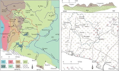
Figure 4. Geo-lithological sketch map of Upper Scrivia valley with semi-quantitative petro-physical parameters. Legend: (1) conglomerates (good quality rock masses); (2) marly limestone (fair quality rock masses); (3) shales, sandy shales and marls (poor quality rock masses); (4) alluvial deposits; (5) large-scale landslide and (6) DSGSD.
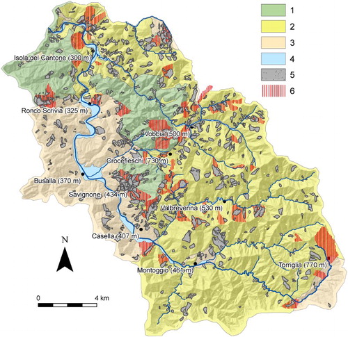
Figure 5. Large-scale landslides types and morphotectonic elements. (a) Costa Clavarezza complex landslide (Vobbia valley) highlighted by snow cover; (b) Trench in a slope near Crocefieschi (Vobbia river valley); (c) Savignone village on landslide deposits downslope of a conglomerate escarpment; (d) counterslope bordering a closed depression with swampy deposits and marsh vegetation close to Mt. Porale; (e) Nenno village complex landslide downslope of scarps in marly limestone and (f) lower part of the Case Tanadorso lateral spread above the contact between clays and conglomerates.
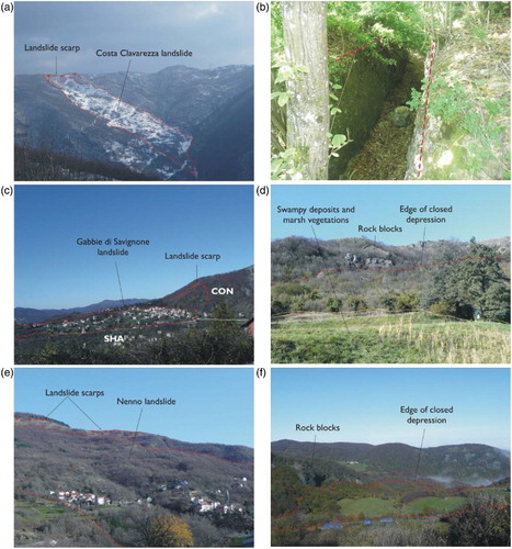
Figure 6. Pictures of six case studies; (a) Gabbie di Savignone: lateral spread phenomena Conglomerate/Shales contact; (b) Prarolo (Isola del Cantone): blind valley on the right along a slope characterized by para-karst forms (sinkholes); the profile simulates a valley trend determined by the core of an anticline where the weak Montoggio Shales outcrop; (c) Cipollina (Ronco Scrivia): wide reverse slope and closed depression at Case Porale with marsh vegetation; (d) Sorrivi: scarp/counterscarp slope around the Conglomerate and marly-limestone contact. The conglomerate block is tilted and the slope below the village is characterized by massive presence of rock blocks; (e) Arezzo di Vobbia: note the low ridge and stepped profile. The village lies on an active landslide and (f) Bric Castellazzo at Montessoro (Isola del Cantone): low ridge simulates a syncline strata bedding. Note the complex landslide scarp.
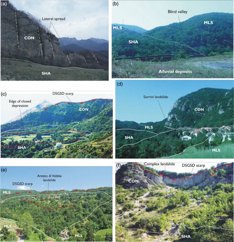
Figure 7. Geomorphological cross-sections of six different case studies (Gabbie di Savignone, Prarolo, Case Tanadorso e Cipollina, Sorrivi e Nenno, Arezzo di Vobbia, Bric Castellazzo e Montessoro) of large-scale landslides and DSGSDs. MLS: marly limestone with shale interlayers, CON: Conglomerate, SHA: mainly shales.
