Figures & data
Figure 1. Study area and its major geomorphological and geological locations. The yellow region delineates the area within which it was possible to map geomorphological features in WDML and the background data are the MODIS MOA (CitationHaran et al., 2005). The inset shows the location of the study area.
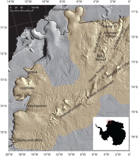
Figure 2. Current knowledge of bed topography in WDML. (a) Survey line locations (yellow) used in BEDMAP2 bed topography (CitationFretwell et al., 2013). Note the relatively sparse data over the Borg Massif, Kirwan Escarpment and Vestraumen; (b) Corresponding BEDMAP2 bed elevation product for WDML. Note that it is difficult to identify small-scale topographic features in the subglacial landscape. Boxes indicate locations of detailed mapping shown in other figures.
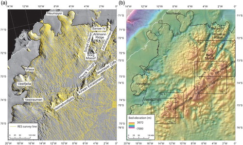
Figure 3. Contextual geological map of the nunatak geology in WDML. The map shows the two distinct provinces (Grunehogna and Maudheim) as well as the location of Jurassic flood basalts, Precambrian basement rock exposures and the sedimentary-volcanic sequences of the Ritscherflya Supergroup. Also shown are the inferred grabens of the Jutulstraumen–Pencksökket triple junction (thick dashed lines). Modified from CitationFerraccioli et al. (2005) using maps by CitationSpaeth and Fielitz (1987).
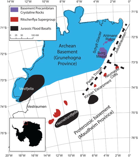
Table 1. Summary of data sources used in geomorphological mapping.
Figure 4. The use of ice surface elevation data for geomorphological mapping. (a) Raster curvature analysis of the RAMP DEMv2 (CitationLiu et al., 2001) at the Heimefrontfjella region; (b) mapped surface geomorphological features and buried glacial breaches. Base data are the RAMP DEMv2.
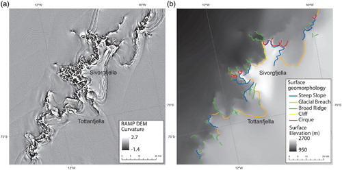
Figure 5. MODIS MOA and its use for mapping subglacial valleys and troughs. (a) Profile Curvature analysis of MODIS MOA data (CitationHaran et al., 2005) around the Jutulstraumen–Penck trough area; (b) Inferred subglacial valleys and troughs.
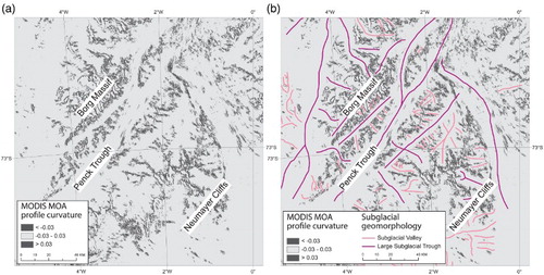
Figure 6. Mapping subglacial valleys around the Kirwan Escarpment. (a) MODIS MOA imagery (CitationHaran et al., 2005) of the eastern Kirwan Escarpment; (b) mapped subglacial valleys by using textural changes on the MODIS MOA data; (c) profile curvature analysis of the same area indicating that features are not always delineated clearly using this method.
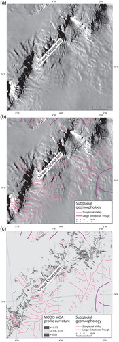
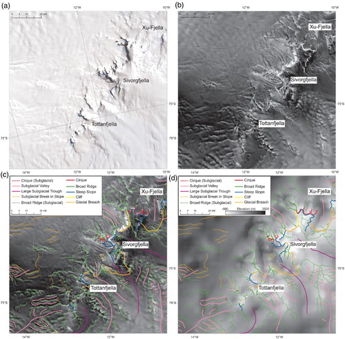
Figure 7. Subglacial mapping of the Heimefrontfjella. (a) LIMA showing uneven linear features extending from the main escarpment; (b) RAMP AMM-1 Image Mosaic of Antarctica version 2 (CitationJezek et al., 2013) which has clearly visible linear features which are interpreted as a network of subglacial ridges; (c) Mapping of these ridges and other geomorphological features; (d) Geomorphological features overlain on BEDMAP2 bed topography to illustrate the fit with known topography and the additional topographic detail provided by the mapping.